Listen live to WTOP for the latest on storm damage and outages.
The D.C. region continues to recover after Saturday’s severe storm ripped through the area, toppling trees, and knocking out power for thousands across the area. Here’s what you need to know.
- Traffic Impact: Part of the George Washington Memorial Parkway reopened Tuesday as crews removed literal tons of trees, branches and other debris from the road.
- Current Outages: As of Tuesday afternoon, the number of customers without power continued to dwindle as power companies work to restore electricity to residences. While most residents of suburban Maryland and Northern Virginia have seen their power restored, there area about 370 residents in Northwest D.C. who remain in the dark.
GW Parkway cleanup
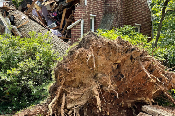
Part of the George Washington Memorial Parkway reopened Tuesday afternoon after being shuttered for nearly two days as crews worked to clear more than 500 tons of trees and other debris.
As of Tuesday afternoon, one lane was open on the northbound parkway between Spout Run Parkway and the Capital Beltway in Virginia after being closed following the storm.
The southbound lanes remain closed as storm debris cleanup continues, so southbound traffic will not be getting by between the Capital Beltway and the Roosevelt Bridge.
Although one lane of the parkway reopened, it was unclear if the second, reversible lane in the long-term work zone would be ready for rush hour traffic Tuesday.
In a news release, Charles Cuvelier, the superintendent of the GW Parkway, said crews on Monday removed between 250 and 325 hazardous trees, filling up 100 dump trucks and 15 chipper trucks of debris. All told, crews cleared more than 500 tons of wood and other debris from the parkway.
On the other side of the Potomac, in Northwest D.C., Canal Road remains blocked between Foxhall Road and Arizona Avenue, as does Arizona Avenue and Loughboro Road, according to Dave Dildine in the WTOP Traffic Center.
The continued closure of Canal Road through the Palisades area of D.C. could further complicate the outbound rush hour between the Key Bridge and Chain Bridge, Dildine said.
You can see a map of other road closures in D.C. on an interactive map released by District officials.
Where outages stand
As of Tuesday afternoon, Pepco said it had restored power for about 99% of customers.
However, about 370 Pepco customers — clustered in the Northwest neighborhoods of Palisades, Foxhall Village and American University Park — remained without power.
Pepco had originally hoped to have power restored for all customers by 3 p.m. Tuesday.
At the height of the outages, Pepco officials said about 70,000 Pepco customers across the region were without power.
D.C. Mayor Muriel Bowser toured some of the hardest-hit areas of Northwest D.C. Monday afternoon along with officials with Pepco.
Forecast
As August begins, Tuesday and Wednesday will have similar weather as there will be sunshine and very low humidity with dew point in the 50s, and warm afternoon highs in the mid-80s. Skies will be clear Tuesday night to see a rare super blue moon shining bright in the sky and a NASA Rocket Launch, according to 7News First Alert meteorologist Brian van de Graaff.
It will be more humid on Thursday with dew points around 70 degrees. There is an isolated chance for a shower or storm on Thursday and Friday.
The first weekend of August will be warm and muggy, van de Graaff said.
- TUESDAY: Mostly sunny, low humidity. Highs in the mid-80s. Winds: North 5-10 mph.
- TUESDAY EVENING: Mainly clear. Lows: 58-65. Winds: Northeast 5 mph
- WEDNESDAY: Partly to mostly sunny. Highs in the mid-80s. Winds: North to Southeast 5-10 mph.
- THURSDAY: Partly to mostly cloudy, breezy with chance of rain and storms. Highs in the mid-80s. Wind: South 10 to 15 mph with gusts of up to 25 mph.
- Listen to WTOP online and on the radio at 103.5 FM or 107.7 FM.
- Current traffic conditions
- Weather forecast
- Closings and Delays
- Sign up for WTOP alerts
Memories of 2012 derecho
The storm was marked by powerful winds, including one monster gust recorded at George Washington University’s Mount Vernon campus in Foxhall Village that notched a whopping 84 mph, according to the National Weather Service.
“We saw some pretty significant damage to a couple of houses and vehicles,” Bowser told reporters. “We were able to talk to some residents who were in their homes during the storm, and were pretty terrified by it.”
She added that “sometimes when we hear numbers, we can’t appreciate it…I don’t really know what it means to be 85 mph. But it takes down some pretty significant trees.”
Christopher Rodriguez, director of the D.C. Homeland Security and Emergency Management Agency, said the storm brought back thoughts of the devastating 2012 derecho.
He said that the “extreme heat” that brought alarmingly high temperatures to the D.C. area last week along with a cold front approaching from the west and the extreme humidity in the air caused a downburst.
“What happens is a lot of wind and a lot of rain hit the ground very fast,” Rodriguez said.
The storms very rapidly sprang up, he said. As of 2 p.m. Saturday, the radar was showing “absolutely no systems in the area,” he said. But shortly after 4 p.m., the winds were howling and dumping buckets of rain.