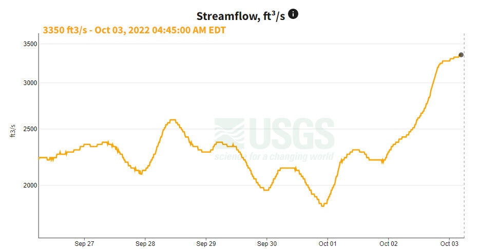
Streamflow of the Potomac River was so low that daily drought monitoring in the D.C.-area’s prime drinking water source was about to begin — and then the remnants of Hurricane Ian arrived.
On Friday, Sept. 30, the flow of the Potomac River dipped below 2,000 cubic feet per second at Point of Rocks, Maryland.
- Listen to WTOP online and on the radio at 103.5 FM or 107.7 FM.
- Current traffic conditions
- Weather forecast
- Closings and Delays
- Sign up for WTOP email alerts
- Get custom alerts with the WTOP app for Apple and Android phones

Dropping below that threshold triggers daily drought monitoring by the Interstate Commission on the Potomac River Basin. The flow is measured by the U.S. Geological Survey stream gage at Point of Rocks.
The gage is near the bridge connecting Maryland’s Frederick County with Loudoun County, Virginia, and is located upstream from the Potomac River intakes for the Washington Aqueduct, WSSC Water and Fairfax Water.
When the daily drought monitoring is in effect, daily email reports are sent to agencies, utilities, and other stakeholders summarizing the Potomac River’s flow, weather and demand conditions.
The monitoring updates are made available each morning on the Cooperative Water Supply Operations data portal.
If drought conditions persisted, the daily data would provide utilities the information to develop plans to coordinate releases from upstream and off-river reservoirs, to ensure there’s enough water to meet expected needs of the region.
However, with rain stretching into a third day, the stream flow at Point of Rocks on Monday morning was nearing 3,500 cubic feet per second, and continuing to rise, averting the threat of drought.


