Key points:
- A Winter Weather Advisory is in effect through 7 a.m. Friday for the D.C. and Baltimore metro areas, parts of central and southern Maryland, and portions of northern Virginia.
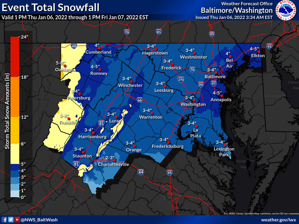
- Totals: Between 2 and 4 inches for most, with up to 6 inches possible in higher elevations.
- The heaviest snow will fall from 10 p.m. Thursday to 2 a.m. Friday.
- Icy road conditions will affect Friday morning commute.
Winter is here in force after an unusually warm start to the season: A second round of snow will complicate travel for a region still dealing with the fallout of Monday’s record-breaker.
While Thursday night’s forecast isn’t as bullish as what the D.C. area experienced earlier this week, it will still prove more than enough to make road conditions hazardous. Between 2 and 4 more inches of snow will blanket most of the region by sunrise Friday, with the heaviest falling between 10 p.m. Thursday and 2 a.m. Friday.
Anyone out during those hours could encounter snowfall rates of around an inch per hour, with visibility reduced to one half-mile or less. Although precipitation will be tapering off by the time most drivers would hit the road Friday morning, frigid temperatures combined with rapid accumulation will make for widespread icing that could take time to treat.
“This will not be as big of a storm as the last one, but it will be enough to cause serious issues with the Friday morning commute,” Storm Team4 meteorologist Chuck Bell said. “Plan for schools to be closed and to work from home, if you can, to avoid being on the roads.”
Several school systems have announced schedule changes for Friday, including Fairfax and Loudoun counties in Virginia. For a full list, visit WTOP’s Closings and Delays page.
- Listen to WTOP online and on the radio at 103.5 FM or 107.7 FM.
- Current traffic conditions
- Weather forecast
- Closings and Delays
- Sign up for WTOP alerts
Rain or a wintry mix will overspread the area from west to east starting around dusk Thursday. Falling temperatures will have the entire WTOP listening area seeing all snow soon after the sun sets, with a steady snowfall expected from around 10 p.m. to 5 a.m. Friday.
“The one thing preventing higher snowfall amounts will be that this is fast-moving,” the National Weather Service said in its Thursday forecast discussion.
Compared to Monday’s storm — which featured a sharp gradient of snow totals — Thursday night’s outlook also calls for a much more uniform winter weather event.
“Most of our viewing area will end up in the 2- to 4-inch range, and the snow will be evenly distributed, unlike the last storm which left an inch to the north and a foot to the south,” Bell said. “The only locations that are likely to get more than 6 inches will be elevations above 1,500 feet.”
Dry and chilly today. A low pressure system will bring accumulating snow to the region tonight. Winter headlines have been issued for the entire region. For more information, please go to https://t.co/FdluCAnbTi pic.twitter.com/WOFQXnaC2Z
— NWS Baltimore-Washington (@NWS_BaltWash) January 6, 2022
Storm Team4 Meteorologist Matt Ritter said the snow from this storm should be drier and fluffier than the previous system, which will make it easier to clean up afterward.
Gov. Ralph Northam declared a state of emergency in advance of Thursday night’s storm, noting that the state’s resources are stretched thin, with thousands still without power from downed branches in northern and central Virginia.
“Having two bouts of snow and icy weather back-to-back makes it more likely communities will need additional help as they continue to recover from the first round of tree-snapping wet snow and ice that we saw Monday,” Northam said. “While we typically have ample resources for snowstorms, these back-to-back events will generate landmark winter weather that requires extra flexibility.”
Virginia Department of Transportation spokeswoman Kelly Hannon said tankers began pretreating Interstate 95 with a salt brine solution on Thursday morning, and said crews will prioritize clearing operations on major highways and primary roads during the height of the storm.
“When snow is actively falling, we make repeated passes to keep roads clear for those who must be out — medical personnel, essential personnel, people who must travel — we recognize that and understand it,” Hannon told WTOP. “When snow begins to fall tonight, people will kind of see us divert from roads we’re still plowing to make those repeat passes on ones that are already clear, like I-95 and U.S. 17.”
Hannon asked drivers to reconsider nonessential travel. If you must be out, significantly reduce your speed to allow for extra following distance. Clear snow off the roof of your vehicle, windshield and mirror before driving.
“We remain in maximum mobilization,” she added. “We are able to pretreat with this event, we are fully prepared with the materials we need … we will be out in force, we will be treating, we will be plowing in repeated passes, we have towing crews that will be there to respond to vehicles that may become disabled.”
Virginia closes some vaccination sites ahead of storm
The Virginia Department of Health is closing five of its Community Vaccination Centers Friday, in preparation for the coming storm. VDH said those with appointments will be notified of the cancellation.
The centers in Charlottesville, Fairfax, Fredericksburg, Prince William and Roanoke will be closed Friday. VDH said they will decide on Friday whether to open the closed sites on Saturday.
Several testing sites in Maryland will have delayed opening times Friday, the Maryland Department of Health said. The following sites will be open noon until 6 p.m.: Annapolis on the corner of Bladen and Calvert streets; Anne Arundel Medical Center; Johns Hopkins Bayview Medical Center; UM Upper Chesapeake Health; City of Praise Family Ministries; and UM Laurel Alternate Care Site Testing Site.
Due to the anticipated winter storm, the Maryland Department of Health (MDH) announced today that MDH testing and vaccination sites will delay their opening times tomorrow, Friday, Jan. 7.
Mass transit and traffic:
Metrobus: Some routes may not operate or experience longer wait times than usual due to a driver shortage. A moderate snow service plan begins Friday, in which service on some routes is suspended and detours will be in effect on certain routes to avoid areas prone to hazardous conditions, such as hilly terrain and narrow streets. Approximately 119 out of 183 routes will operate, Metro said.
Fairfax Connector: Operating regular schedule, but passengers should check for potential detours and allow for extra time.
Virginia Railway Express: Trains running on an S schedule.
RideOn: Operating as normal, but expect some weather-related delays and detours.
VanGo: Service suspended on the Berry Road, La Plata, Pinefield and Indian Head routes due to driver shortages.
Loudoun Bus: All bus services are operating on a normal schedule.
PRTC OmniRide: No Express or Access service due to limited operator availability. Local and Metro Express routes are operating according to published schedules, but there will be no off-route trips.
Power outages:
Earlier Thursday, Dominion Energy reported more than 13,000 homes and businesses were still without power in Stafford County and an additional 4,000 in King George County. Rappahannock Electric Cooperative reported over 41,000 of its customers are still waiting for power to be restored.
In Maryland, nearly 2,000 SMECO customers in Prince George’s, Calvert, Charles and St. Mary’s counties are in the dark.
Dominion Energy’s Peggy Fox told WTOP that there were about 400,000 outages earlier in the week and crews have restored power to more than 80% of its customers.
“We have 4,800 crews and support staff plus 900 mutual aid workers, who have been here now in Virginia since yesterday helping us get these poles back up, lines back up and power restored,” Fox said.
However, Fox said, there will be a few places, such as areas in Charlottesville, Spotsylvania and Fredericksburg, that are hard to reach and may take more time to restore power. With focus slightly shifting to the upcoming storm, customers should prepare for possible outages Thursday night into Friday morning.
“The branches have already been weighed down by this wet heavy snow,” Fox said. “More snow on top of it could bring more outages so just as we’re preparing, we’re asking customers to prepare as well, charging their devices and making sure that if they need someplace to go that they make arrangements of where they might be able to stay briefly.”
Forecast:
Thursday night: Mix of rain and wet snow arriving after 8 p.m. Changing to all snow around midnight. Snow may be heavy at times but will be ending before the morning rush. Total accumulation potential for the entire area 2 to 4 inches. Lows in the mid 20s to near 30.
Friday: Becoming mostly sunny. Blustery and cold. Highs in the low to mid 30s.
Saturday: Sunny and cold but with less wind. Highs in the low to mid 30s.
Sunday: Rain arriving, possibly starting as freezing rain and sleet. Highs in the upper 30s to low 40s.