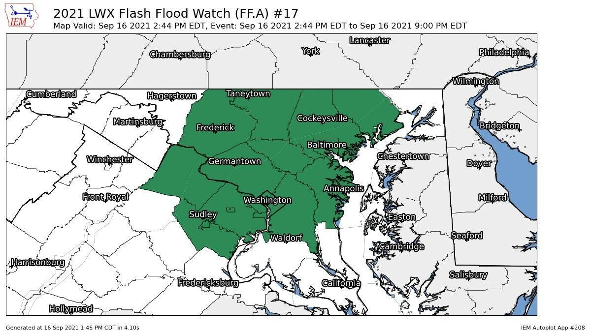
Slow moving thunderstorms poured several inches of rain in a matter of hours on the D.C. region, and some drivers had to be rescued after their vehicles got stranded in flood waters.
Much of the flash flood warnings were canceled just before 7 p.m., while the flash flood watch the National Weather Service had much of the area, particularly the metro counties and northern Maryland, ended before 9 p.m. Thursday.
A flood warning was also in effect for D.C., Montgomery and Prince George’s counties in Maryland and Arlington County and the city of Alexandria in Virginia until 9:30 p.m.
Fairfax and Prince William counties and the cities of Manassas and Manassas Park were under a flood warning until 10:30 p.m. That flood warning, as well as the Baltimore City and County warnings was cancelled.
A watch means flash floods are possible in and near the area; a warning means they’re imminent or are already happening.

Some of the storms brought heavy rains with them, and they arrived just in time to severely complicate the evening commute.
Storm Team4 Meteorologist Matt Ritter said estimates indicated between 1 and 2 inches of rain had fallen in just an hour in D.C. and some of the surrounding areas.
“We don’t have a lot of room for the water to go because of all the rain we’ve gotten over the past month and a half or so, and it wouldn’t take much for flash flooding to start — especially in a lot of the highly developed areas inside the beltway,” Ritter said. “This is a serious situation — this is life-threatening.”
Ritter said some areas could see a total of 4 inches of rain before the storms finally move out of the region around 9 p.m. He warned that flood waters could take several hours after the rains let off to begin to recede.
Waters recede
Flood waters lessened after a string of afternoon thunderstorms and severe rain.
The low lying residential road near Accotink Creek in Fairfax County, for example, saw road closures in both directions. The roads saw at least 50 feet of water and a vehicle perched on it’s side beyond the road’s edge.
Woodburn Road at Spicewood Drive in Fairfax County hit by flash flood. The site of the flooding is a low lying residential area where Woodburn crosses Accotink Creek. Road closed in both directions @wtop pic.twitter.com/aanvFsJxkK
— Dick Uliano (@DickUliano) September 16, 2021
Overwhelmed storm drains like the ones at the Braddock Road Metro Station are already seeing a decrease in intense runoff.
However, as the region moves into a humid Friday, D.C. drivers may see some more scattered thunderstorms. Those storms may be heavy, but are not expected to be as numerous at the time of this reporting.
New waterfall features added to the DC Metro. Very cool! pic.twitter.com/DPQqxRVrLQ
— (@mnolangray) September 16, 2021
Traffic impacts
Heavy rain worsened area roadways that were already experiencing delays by Thursday afternoon. WTOP Traffic Reporter Dave Dildine said Thursday’s rush hour commute was one of the worst the region had seen in weeks.
In D.C., Maine Avenue SW near Independence Avenue began experiencing flooding around 4 p.m.
Dildine said a few drivers on roads in the region got stuck or stalled out while trying to drive through flood waters, and advised drivers to turn around if approaching impassible flood waters.
Fairfax County Fire and Rescue said they had responded to at least three instances of vehicles stuck in flooding roadways: on the 3700 block of Prosperity Avenue, the 5000 block of Terrell Street and the 6200 block of Rolling Road. They advised drivers to avoid these areas while flooding persists.
Units currently responding to three calls for vehicles stuck in flooded roadways.
* 3700 block Prosperity Ave.
* 5000 block Terrell St.
*6200 block Rolling Rd.
Avoid these areas! Please remember to “Turn Around and Don’t Drown” if you come across a flooded road. #FCFRD pic.twitter.com/tpnys0eUNF— Fairfax County Fire/Rescue (@ffxfirerescue) September 16, 2021
Fairfax County Fire and Rescue spokesperson Ashley Hildebrandt told WTOP one car did not have an occupant when first responders arrived at the scene, but that the occupants in the other two instances needed help getting clear of their vehicles.
“This is what we train for,” Hildebrandt said. “We have swift-water rescue teams that can go in and they train constantly for these types of incidents. So we’re prepared for whatever needs to be done.”
There were also a number of water rescues performed for drivers trapped in vehicles in the city of Alexandria.
WTOP’s Thomas Robertson and Dick Uliano contributed to this report.
- Listen to WTOP online and on the radio at 103.5 FM or 107.7 FM.
- Current traffic conditions
- Weather forecast
- Closings and Delays
- Sign up for WTOP alerts
Forecast
- Thursday Night: All remaining scattered showers and thunderstorms ending early, then warm and muggy with patchy fog forming. Lows in the mid 60s to low 70s.
- Friday: Mostly cloudy. Seasonably warm but very humid. Scattered thunderstorms in the afternoon and evening. A few heavy downpours will be possible. Highs in the upper 70s to low 80s.
- Saturday: Partly sunny. Very humid and much warmer. An isolated thunderstorm possible. Highs in the mid to upper 80s.
- Sunday: Mostly sunny, hot and humid with highs in the upper 80s.


