Dangerously hot and humid temperatures have made an encore appearance Thursday, bringing the chance for a pop-up thunderstorm or two.
However, in contrast to Wednesday’s wild weather, storms are not expected to be numerous Thursday.
A Heat Advisory continues for the WTOP listening area through Thursday evening: “Extreme heat and humidity will significantly increase the potential for heat-related illnesses, particularly for those working or participating in outdoor activities,” the National Weather Service said.
Although it’s extremely hot and humid, the atmosphere hasn’t had enough energy to launch any thunderstorms as of about 4 p.m., according to Storm Team4 meteorologist Matt Ritter.
That said, thunderstorm could still pop up, and any storm that does form could be strong or severe.
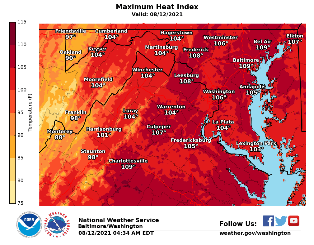
For the second day in a row, heat indexes top out between 105 and 110 along the Interstate 95 corridor. See an interactive map of D.C.’s cooling centers.
Even excluding the humidity factor, air temperatures neared 100 degrees Thursday afternoon, nearing record high.
The last time Reagan National Airport reached 100 was Aug. 15, 2016; D.C.’s average high temperature for this time of year is around 90. Dulles International Airport set a new daily record high of 99 on Thursday, breaking its old record of 97 for Aug. 11 in 2010.
- Listen to WTOP online and on the radio at 103.5 FM or 107.7 FM.
- Current traffic conditions
- Weather forecast
- Closings and Delays
- Sign up for WTOP alerts
The chances for more numerous storms return Friday.
And if you’re tired of sweating, there’s some good news for you: A cold front is expected to sweep into the region this weekend breaking the heat wave.
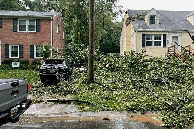
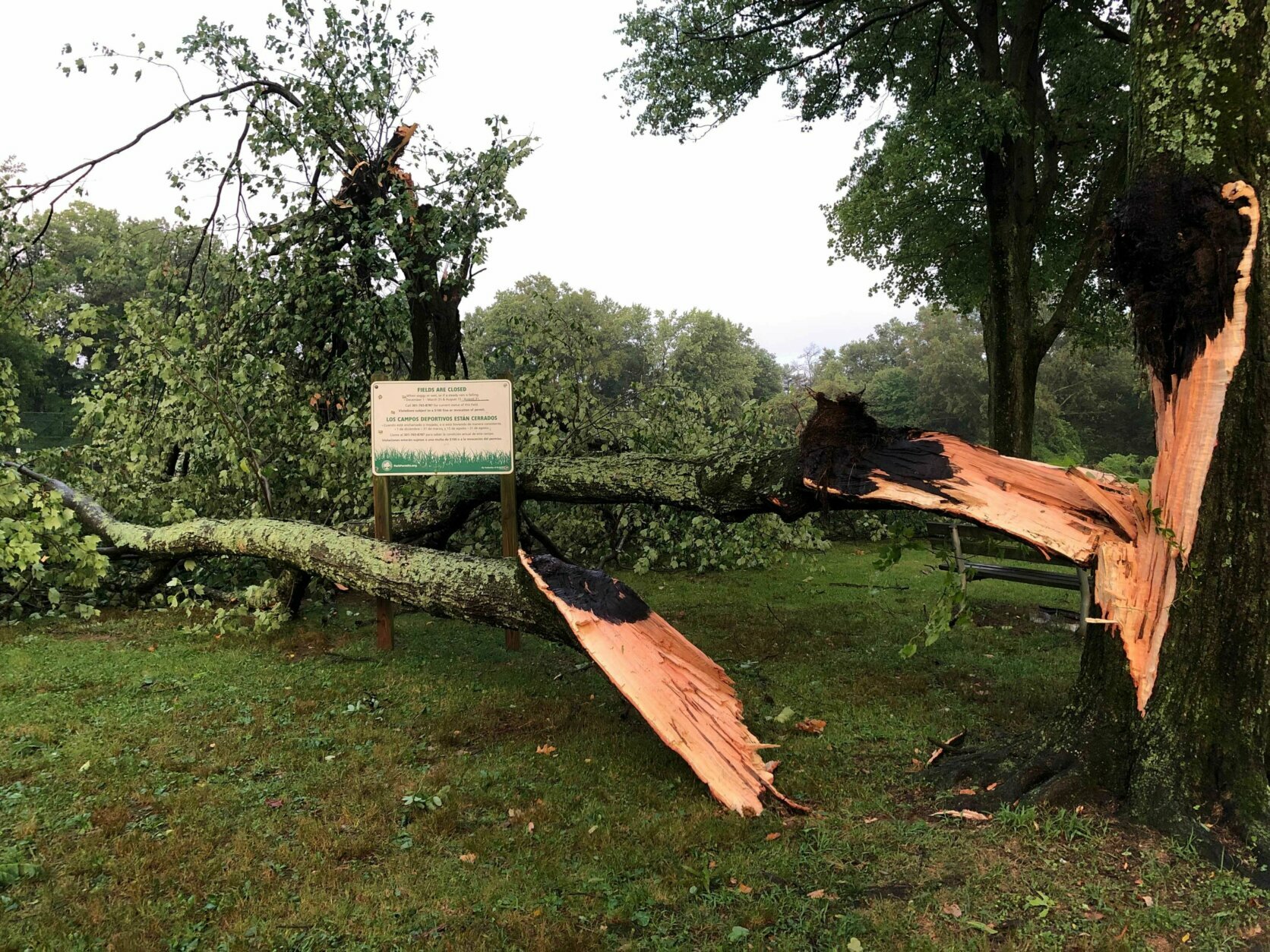
Damage reported from this week’s storms
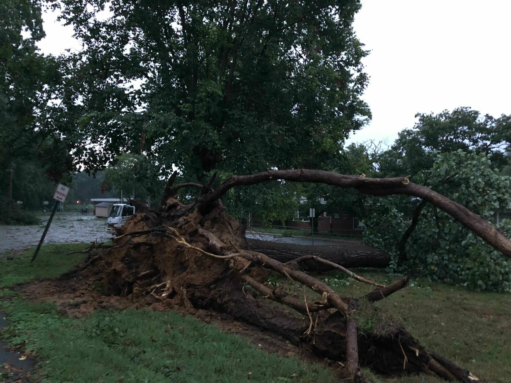
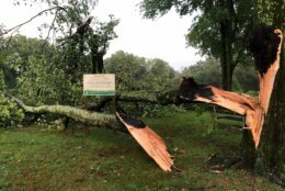
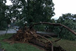
The D.C. area saw severe weather during the last several days this week.
On Wednesday, the National Weather Service issued severe thunderstorm warnings for parts of D.C., Maryland and Virginia, and warned of considerable damage to trees and large branches that could hurt those outdoors, as well as damage homes and vehicles.
Montgomery County Fire and Rescue Service spokesman Pete Piringer reported several storm-related incidents, including a tree that fell into a vehicle with entrapment, a tree blocking Whisper Wood Lane, and a tree that fell onto a house near Cheshire Drive.
He also reported a possible lightning strike on Broad Green Drive near Claggett Farm Drive in Potomac, and a person who was injured by flying debris in Bethesda.
Downed trees in Loudoun County, Virginia, closed Route 9 in both directions at Daymont Lane.
Route 9 is closed in both directions at Daymont Lane due to downed trees.
Please monitor road closures and traffic incidents for #Loudoun County at https://t.co/tL1KrpDjIK.
Learn more about road conditions through 511 Virginia at https://t.co/HoB8mxhoM4. pic.twitter.com/Y4P6OHec2g
— Loudoun County Sheriff (@LoudounSheriff) Aug. 11, 2021
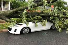
In Montgomery County, Daniel Kosogof stared at a massive tree that had just fallen on a car he bought Tuesday.
“I thought it was just lightning because I was taking a shower and then I come outside and I’m like, ‘Oh, yeah, that was not lightning.’ That was what was once my car … it’s gone now,” Kosogof said.
There was a tree blocking the street over on Wildwood Road in Kensington.
In North Bethesda, a massive downed tree in front of the Luxmanor school drew a crowd Wednesday.
Neusha Arang just moved to North Bethesda from Canada and said she’s never experienced a storm like this one. “Much of rain and wind and everything, throwing flowers everywhere and breaking the trees.”


On Tuesday, powerful winds and frequent lightning left scattered damage in parts of Maryland and Northern Virginia. A bolt of lightning set a Germantown apartment complex ablaze, displacing residents. Emergency responders in the District worked about two dozen calls for downed trees and wires.
Fairfax County resident Tom Waites said a 70-foot poplar tree tumbled into his carport, rending all three vehicles within undrivable.
“I was in the kitchen and all of a sudden, there was a boom — I think it was lightning,” Waites told WTOP. “I didn’t see it, but then I looked out and saw the entire carport had gone down.”
Strong thunderstorms have worked their way across the D.C. region every afternoon this week, a pattern that will hold over the next few days.
Forecast:
Thursday: Hazy, hot and humid. Highs in the mid 90s to near 100. Heat indexes of 105 to 110.
Thursday night: Isolated thunderstorms. Hazy and humid, with overnight lows in the mid 70s to near 80.
Friday: Hot and humid. Storms possible late afternoon to evening. Highs in the mid- to upper 90s. Heat indexes of 102 to 108.
Saturday: Mostly cloudy, not as hot. Still humid. Rain and thunder likely. Highs in the mid 80s to near 90.
Sunday: Mostly cloudy and much cooler. Occasional showers. Highs in the upper 70s to mid 80s.