Flood warning for the areas in bright green so the entire DC Metro area and locations south through late tonight. Turn around don’t drown! pic.twitter.com/ym6NiYZ3WY
— Amelia Draper (@amelia_draper) July 21, 2018
Tonight’s game against the Atlanta Braves has been postponed due to inclement weather.
— Washington Nationals (@Nationals) July 21, 2018
☔️ // https://t.co/XQCfYB8cuG pic.twitter.com/w6hOn2M6yB
Rain moving into the metro areas. Rainfall will be moderate to heavy at times and last through late this evening. Flash Flood Watch remains in effect for portions of northeast Virginia and central Maryland until 2 a.m. pic.twitter.com/ijKzHyE7eF
— NWS DC/Baltimore (@NWS_BaltWash) July 21, 2018
Are you headed to the #Nats game tonight? A good chance of VERY heavy rain through the evening before the first pitch and continuing through the first half of the game - could have some flooding issues. @Nationals @nbcwashington @WTOP ##nationals pic.twitter.com/fuDbW0H1xA
— Lauryn Ricketts (@laurynricketts) July 21, 2018
The suite of computer models differs quite a bit on the amount of rain for tomorrow, and next week, but they have strong agreement that rain is coming. Our local model, shown here, thinks a solid 1-2" of rain likely tomorrow. Rain again on Sunday. pic.twitter.com/IU8hB60VVm
— Chuck Bell (@ChuckBell4) July 20, 2018

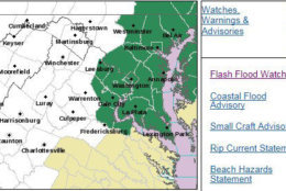

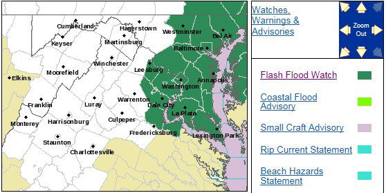
WASHINGTON — The D.C. area, including all of northern Maryland, is under a flash flood watch until 2 a.m. Sunday.
Flash flood warnings are in effect for the following areas:
Virginia
- Loudoun County – until 12:30 a.m.
- Fairfax County – until 12:30 .m.
- Prince William County – until 12:30 a.m.
- City of Manassas – 12:30 a.m.
- City of Alexandria – 11:45 p.m.
Maryland
- Charles County – 10:30 p.m.
- Montgomery County – 2:15 a.m.
- Frederick County – 2:15 a.m.
- Anne Arundel County – 2:30 a.m.
- Baltimore County – 2:30 a.m.
- City of Baltimore – 2:30 a.m.
Parts of northern Virginia, including Loudoun, Fairfax and Prince William counties, are under a flood warning until 1:45 a.m. Sunday.
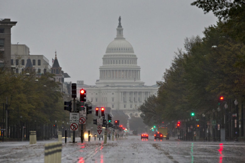
The start of the heavy rain that’s expected to continue throughout the week has already impacted traffic, led to some power outages in the region and canceled the Nationals game Saturday.
Tonight’s game against the Atlanta Braves has been postponed due to inclement weather.
☔ // https://t.co/XQCfYB8cuG pic.twitter.com/w6hOn2M6yB
— Washington Nationals (@Nationals) July 21, 2018
With the heavy rain pouring down in the area, power outages have been reported in the region.
As of 9:45 p.m., more than 400 Pepco customers in Prince George’s County were experiencing power outages and more than 1,500 Dominion customers were still without power in Fairfax County.
The Fairfax campus of George Mason University was also currently without power, reported around 1:30 p.m. on the school’s IT website, but the issue was resolved around 7:15 p.m.
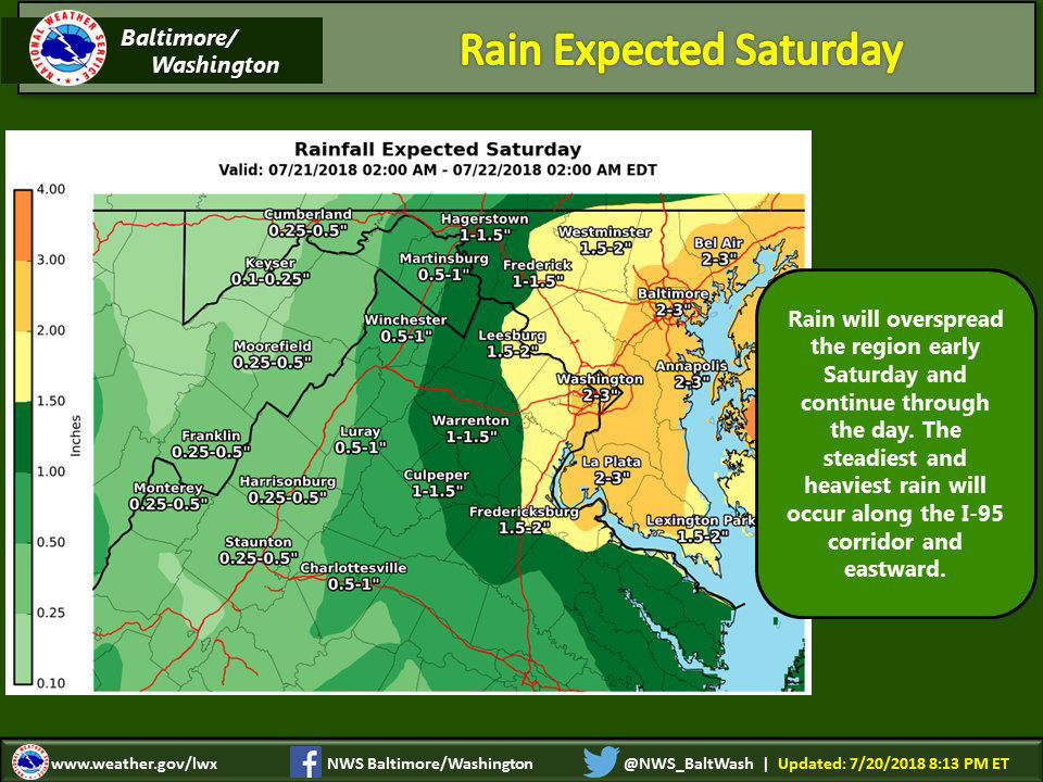
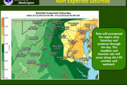
The National Weather Service said the heavy rain is expected to continue into the evening. The region can expect as much as two to four inches of rain.
A flash flood watch means that conditions may develop that lead to flash flooding. Urban areas, locations along small streams and creeks and poor drainage areas are the most vulnerable to flash flooding.
The National Weather Service said shoreline inundation is expected along portions of the seawall adjacent to Ohio Drive and the Hains Point Loop Road near the Tidal Basin and Jefferson Memorial.
Minor inundation flooding up to one foot above ground is possible elsewhere.
Saturday’s rain is expected to be the beginning of an “ugly” weather pattern that settles over the D.C. region this weekend, bringing rain showers and thunderstorms every single day for up to a week.
“We are wedged between a blocking pattern with an area of high pressure in the Midwest and another strong one in the Western Atlantic,” said Storm Team 4 meteorologist Lauryn Ricketts.
“This means that with a trough parked over with nowhere to move, we are looking at daily rain chances at least through Thursday.”
Ricketts said another area of low pressure moving out of the Ohio Valley means there won’t be much let-up on Sunday either.
“While it will rain the entire day Sunday, Sunday will be our best chance for some scattered storms as well,” Ricketts said. “We could have a few peeks of sun, but it is not looking like a good pool day.”
The coming rain is a sharp change in the weather pattern for the month.
Until a brief torrential downpour July 17, Reagan National Airport had recorded only a trace of rain for the entire month so far.
That’s the only time on record, going back to 1871, that no measurable rain fell in the first 15 days of July, according to the National Weather Service.
Current Conditions
Traffic
The rainy weather has led to delays.
WTOP’s Dave Dildine says there are no significant reports of flooding yet, but there are deep puddles on some area roads as the rain continues to move in.
On the George Washington Parkway, near Interstate 395 and the 14th Street Bridge, water is rising in the left lanes but the right lane is passable.
Between Annapolis and Davidsonville, all lanes on Maryland Route 450/Defense Highway are blocked by street flooding between St. Stephens Church Road and Huntwood Drive.
Drivers along Interstate 66 should stay alert on the right side on westbound lanes after Interstate 495 due to street flooding. The eastbound left lane is impassable between U.S. Route 50 and Route 123.
In McLean, Virginia, flooding was reported on Georgetown Pike between Swinks Mill Road and Spring Hill Road.
On Interstate 95, a jackknifed truck on the southbound lanes after the Marine Corps Base Quantico has caused significant delays. The accident has been cleared and all lanes are now open.
For the most updated traffic report, visit WTOP’s traffic center. You can see a map of the latest traffic conditions below.
WTOP’s Jack Moore contributed to this report.