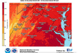
HEAT ADVISORY issued for Sunday. Significant heat may continue through at least Monday. Take appropriate precautions to avoid any heat related illnesses. pic.twitter.com/pwWnKv0RoK
— NWS DC/Baltimore (@NWS_BaltWash) June 30, 2018
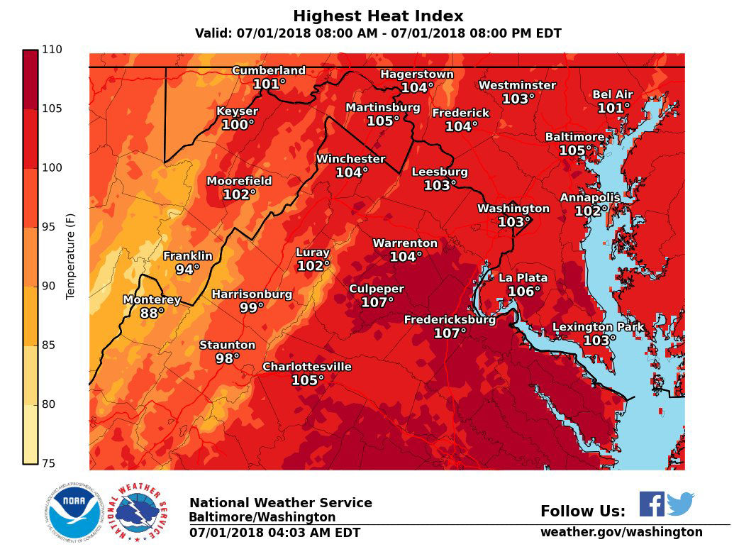
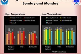
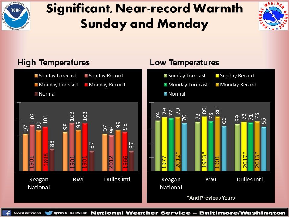
Adding the historical perspective, here are the record highs and warm lows for the next couple of days. These records may be challenged. Even if the records are not broken, the combo of heat and humidity will be impactful. Remain hydrated and reduce strenuous activity. pic.twitter.com/McucZK2V8V
— NWS DC/Baltimore (@NWS_BaltWash) June 30, 2018
WASHINGTON — Your Sunday plans should probably involve a pool or the great indoors, because it’s going to be hot, hot, hot, with temperatures rising into the 100s.
On the third day of the D.C. region heat wave, the National Weather Service canceled a heat advisory that was set to expire at 8 p.m. But the heat should still be taken seriously.
Sunday’s Code Orange air quality alert makes pollution concentrations within the region unhealthy for sensitive groups.
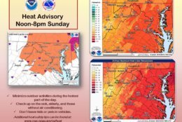
[545pm] Although the Heat Advisory for today has been cancelled, the heat should still be taken seriously. Heat illness remains possible if precautions aren’t taken. Heat Index values will be in the 90s-around 100° for the next couple hours. Heat Advisory in effect noon-8pm Mon.
— NWS DC/Baltimore (@NWS_BaltWash) July 1, 2018
Records for Sunday and Monday may not be broken in the D.C. region, but considering that the normal temperatures at this time of year are around the high 80s, the heat and humidity for the next couple of days will have an impact on the area.
Forecast
Both Sunday and Monday are weather alert days because of the dangerous heat, Storm Team 4 meteorologists say. The heat index could top 105 on both days.
The heat advisory will hit the region again on Monday from 12 p.m. to 8 p.m. and Tuesday can also bring about significant heat, according to the National Weather Service.
On Tuesday, the weather will be sunny and hot still, with highs in the mid 90s and a heat index of 100 — only slightly lower than Sunday and Monday’s temperatures.
Wednesday, July 4, will be sunny, dry and hot, with temperatures in the lower and mid-90s and a heat index in the upper 90s.
Experts warn residents to be “heat smart.” Some things you can do to help beat the heat are:
- Limit strenuous outdoor activities
- Don’t leave kids or pets in a closed car
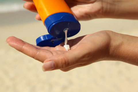
- Drink more water
- Drink less caffeine and alcohol
- Check on senior friends and neighbors
- Take frequent breaks
- Get medical help if you stop sweating
- Adults should take corrective action, and children should seek help, if they feel nauseous, their face feels like it’s burning or they have muscle cramps
- Make sure outdoor pets have ample shade and water
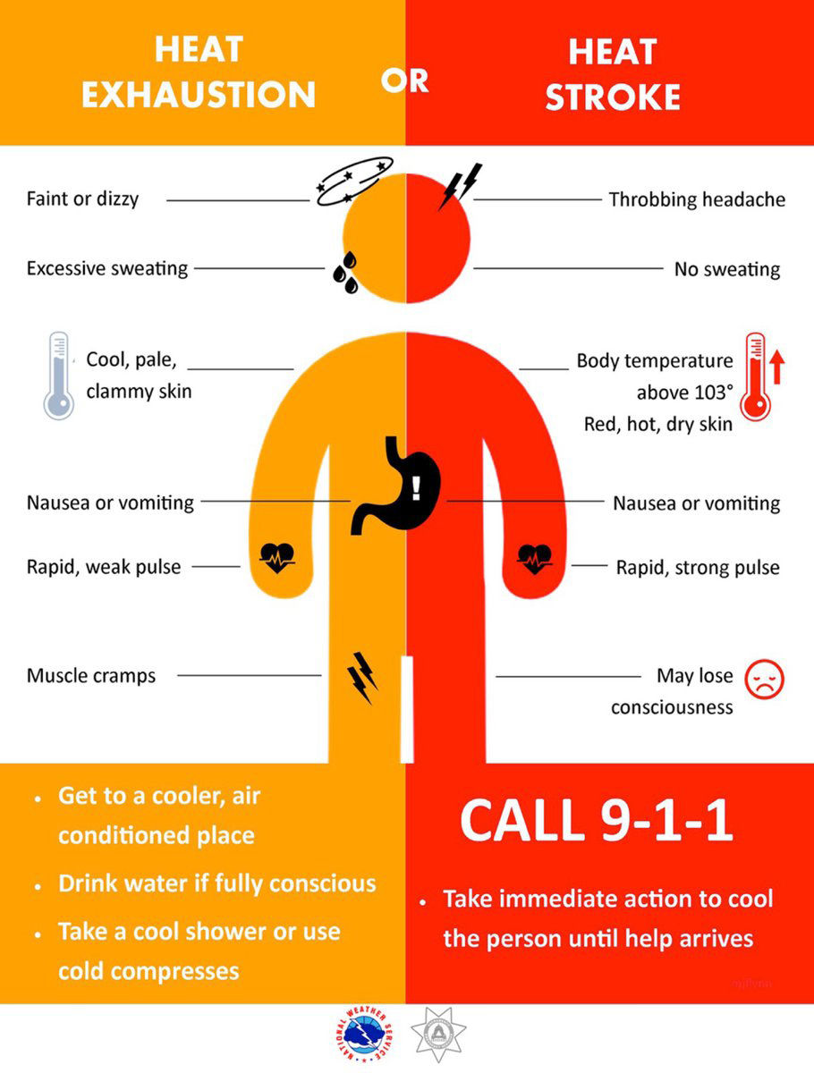
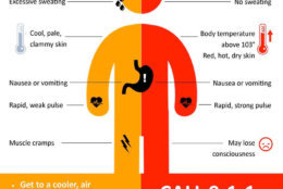
The Centers for Disease Control and Prevention has specific recommendations for the symptoms of heat exhaustion and the even-more-serious heat stroke.
Heat exhaustion
- Nausea or vomiting
- Cold, pale, clammy skin
- Heavy sweating
- Fainting
Under those circumstances, you should move to a cooler location, loosen your clothes, lie down, apply wet, cool cloth to as much of your body as possible and sip water. If you continue to vomit, seek medical help right away.
Heat stroke
- Body temperature above 103 degrees
- Hot, red, dry or moist skin
- Fast and strong pulse
- Possible unconsciousness
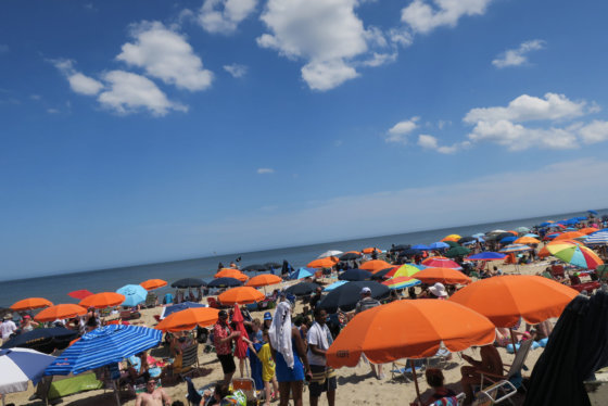
Beach Forecast
Area beaches are going to be a lot cooler. Ocean City, Maryland, temperatures are 89 degrees for Sunday and 87 degrees for Monday.
There are air quality alerts and heat advisories until 10 p.m. in effect for Rehoboth and Bethany beaches.
Highs for Rehoboth Beach is 91 degrees on Sunday and 87 degrees on Monday. For Bethany Beach it’s 84 degrees for Sunday and Monday.