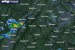
Meanwhile, in storm-weary areas of VA: * Severe Thunderstorm Warning for... Southeastern Madison, Central Orange, Southeastern Rappahannock, & Culpeper Counties Until 345 PM EDT. #wtop #nbc4dc #vawx pic.twitter.com/qnBiGZyvVK
— Met. Matt Ritter (@MetMattRitter) June 24, 2018
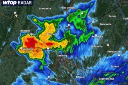
The Loudoun County t'storm has dropped below severe limits so the warning is dropped a little early. Still some heavy rain, small hail, and lightning heading over Waterford, Lucketts, and to Point of Rocks. #wtop pic.twitter.com/UrIVWAuvOt
— Met. Matt Ritter (@MetMattRitter) June 24, 2018
Scattered thunderstorms developing in the higher elevations. They will grow and move east through the afternoon into early evening. Not all will get them, but those who do will have the potential again of some gusty winds and large hail. pic.twitter.com/1sy9EyZQhw
— Met. Matt Ritter (@MetMattRitter) June 24, 2018
Many areas are seeing some sun this morning, and this will continue into early afternoon. Scattered thunderstorms are expected to develop early this afternoon, some of which could be severe. Primary threat is for some damaging wind gusts. pic.twitter.com/UYCBrQvpTw
— NWS DC/Baltimore (@NWS_BaltWash) June 24, 2018

WASHINGTON — Enjoy the sun while you can: Storms have begun to threaten from the south, some of which may be severe.
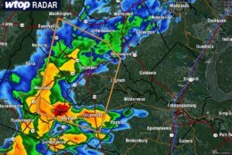
A severe thunderstorm warning is in effect until 6:45 p.m. in Carroll, Harford, Frederick and Baltimore counties in Maryland.
Warnings for severe thunderstorms in Montgomery and Frederick counties in Maryland and Loudoun County in Virginia expired earlier Sunday afternoon, but areas west of the D.C. area are feeling the severe storm threats.
Meanwhile, in storm-weary areas of VA: * Severe Thunderstorm Warning for… Southeastern Madison, Central Orange, Southeastern Rappahannock, & Culpeper Counties Until 345 PM EDT. #wtop #nbc4dc #vawx pic.twitter.com/qnBiGZyvVK
— Met. Matt Ritter (@MetMattRitter) June 24, 2018
Storm Team 4 Meteorologist Somara Theodore says the storms have also begun south and west of Luray, Virginia, and the National Weather Service has also issued a severe thunderstorm warning for the Staunton region.
Theodore says storms should clear just before sunset — and shouldn’t have a major impact on the Nationals game tonight.
If you are out grilling on this Sunday evening keep an eye to the sky or on your radar app (@nbcwashington has a great one)-A few storms are possible this afternoon —some of which could be strong. Otherwise, the sun going down at 8:37pm! Enjoy! pic.twitter.com/Q9vojKAnfW
— Lauryn Ricketts (@laurynricketts) June 24, 2018
Storm Team 4 Meterologist Matt Ritter says that not all areas will see storms, but those that do have the potential to deal with gusty winds and large hail.
Fortunately, the storms clear out overnight. Temperatures will be in the upper 60s to low 70s, before jumping up to the low 80s for a mostly sunny start to your week.
Weather Forecast:
Monday: Mostly sunny with temperatures in the low 80s.
Tuesday: Mostly sunny with temperatures in the low 80s.
Wednesday: Partly sunny, then storms. Temperatures in the low to mid 80s.