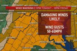
WEATHER ALERT FRIDAY! Wind gusts 50-65mph possible from sun-up to sun-down on Friday. This will be our windiest day since Super-Storm Sandy 5 1/2 YEARS ago! Secure all outdoor items today! Best to get preps done this AM, rain moving in later today. pic.twitter.com/BSaleRf8Fg
— Chuck Bell (@ChuckBell4) March 1, 2018
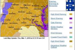
High Wind Warnings in effect from the Potomac Highlands to the Chesapeake Bay Thurs ngt through Fri ngt. High Wind Watches in effect for NE Maryland for the same time period. In the warnings, expect northwest winds of 25 to 35 mph with gusts over 60 mph causing power outages. pic.twitter.com/4eFU8sRrQ8
— NWS DC/Baltimore (@NWS_BaltWash) March 1, 2018
With the strong and potentially damaging winds expected Friday, make sure you're prepared for power outages. Visit https://t.co/cH72ipQbu0 for items to have in your emergency kit. pic.twitter.com/qHJlBG5FZ5
— NWS DC/Baltimore (@NWS_BaltWash) March 1, 2018
During high winds on Friday, March 2, Fire/EMS call volume is anticipated to be high as we respond to a variety of incidents. Only call 911 if you have an emergency. For Example: Checking to see when power is going to be restored is not an emergency. #PGFD @PGPSC
— Mark Brady (@PGFDPIO) March 1, 2018
Urgent message from @DDOTDC: Due to High Wind Warning, PSRA is advising all private users of public space to take precautionary measures to secure active work zones. Secure all fences, signs, equipment, and materials to prevent displacement. Water-filled barriers must be filled.
— ABC Metro Washington (@ABCMW_News) March 1, 2018
WASHINGTON — Brace yourself for downed trees, power outages and complicated commutes on Friday, when a powerful windstorm roars through the D.C. area.
Wind gusts could even approach 70 mph, according to the National Weather Service.
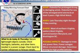
A High Wind Warning, extending from the Potomac Highlands to the Chesapeake Bay, will be in effect from midnight Thursday to 6 a.m. Saturday.
A High Wind Watch will also be in effect for parts of northeast Maryland.
Quick Links
“The reason this is a High Wind Warning, not just an advisory, is because we’re talking about pretty much all day tomorrow,” said Storm Team4 Meteorologist Matt Ritter, who expects the stronger gusts to be “in some of the higher elevations and out towards Chesapeake Bay.”
The potential exists for gusts approaching 70 mph Friday, as well as a long duration of gusty winds over 30 mph into Sunday, the weather service said.
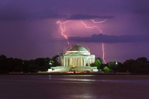
Friday could wind up being the windiest day for the D.C. area since Hurricane Sandy in October 2012.
Dangerously strong, and long-lasting winds coming – starting at, or soon after, midnight. Here’s what to expect, & some actions to take to be ready. pic.twitter.com/OBKdiMEg1g
— NWS DC/Baltimore (@NWS_BaltWash) March 1, 2018
“Hurricane Sandy brought 61 mph wind gusts to [Reagan National Airport] and we could see something similar Friday,” said Storm Team4 Meteorologist Doug Kammerer.
The winds will be generated by a “powerhouse of an ocean storm,” said Storm Team4 Meteorologist Chuck Bell. The Nor’easter won’t bring any snow to the D.C. area, “but it is going to really crank up the winds around here.”
Bell recommends using Thursday to secure all outdoor items, such as trash cans and outdoor furniture, before the winds pick up.
Forecast
Occasional showers are expected for the rest of Thursday as the winds gear up. The one bit of good news: Rain and precipitation won’t be much of an issue.
“The rain looks like it will be fairly constant, but the rain itself doesn’t look like it will be all that heavy,” Ritter said. “All the winter weather, really, from this system, which is going to become a very strong Nor’easter, is going to be up in New England.”
Thursday night lows could dip into the upper-30s, and the winds could make it feel even colder.
Friday could actually begin with snow showers — which, combined with wind, could affect visibility during your morning commute. (No accumulation is expected.) Highs Friday could reach 50, but those winds will make it feel much colder — with wind chills in the 20s and 30s.
Saturday will still be windy, but the winds won’t be anywhere near as damaging. Highs could reach the mid- to upper-40s.
“By the time you get to the second half of the weekend, we’re just left with breezy conditions,” Ritter said.
Travel
The gusty winds could also make for hazardous travel conditions, especially for drivers in trucks, vans and SUVs.
“Even driving around, it’s going to be difficult to drive in a straight line,” said Chris Strong, a meteorologist with the National Weather Service.
Officials with the Maryland Department of Transportation’s State Highway Administration urge drivers to stay informed about conditions and “make smart travel decisions” Friday morning. Visit www.md511.org for real-time travel alerts and conditions, follow them on Twitter, or “like” their Facebook page.
If you’re planning to travel on Maryland’s toll bridges, the state’s Transportation Authority advises you to check out wind warnings and restrictions criteria on the authority’s website.
Motorists are also reminded to be extra careful. Here are some other tips:
- If power is out at a traffic signal, Maryland law requires all drivers at the intersection to treat it as a four-way stop.
- Stay away from downed lines.
- Don’t park near trees, and don’t try moving fallen tree branches, as high-voltage wires may be intertwined.
- Don’t drive through standing water. (It just takes 6 inches of moving water to sweep a person off their feet, officials said, and 12 inches of moving water to move the average sedan.)
- Use low-beam headlights when windshield wipers are activated.
MDOT said Thursday that it has prepared for the likelihood of downed trees. Chainsaws and chippers are at the ready, and the department is also inspecting drainage ditches in case rains are heavier than expected.
For the most updated traffic report, visit WTOP’s traffic center.
Transit
Metro trains and buses are expected to run on a regular weekday schedule Friday.
All above-ground track work has been canceled Thursday night. Track crews will instead patrol above-ground sections to look for any obstructions that could impact service. Additional staff is being brought in to help with the effort.
Check MetroAlerts and the Metrobus Twitter feed for information on any delays or detours due to downed trees or power lines.
MetroAccess customers should consider canceling their trips if travel is not essential.
“While MetroAccess will make every effort to provide service as safely and as close to schedule as possible, it is possible that weather conditions may cause delays,” Metro said in an alert issued Thursday evening.
In Maryland, commuter bus service will not operate in Queen Anne’s County due to the possibility of travel restrictions on the Bay Bridge. (Sign up for related alerts on the Maryland Transit Administration website.)
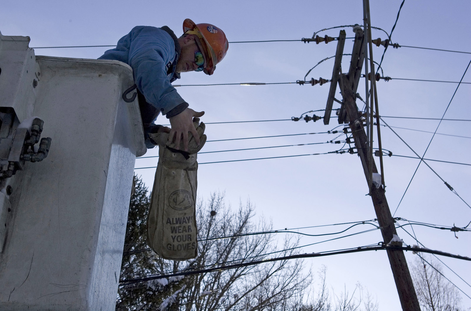
Power outages
“We’re expecting trees possibly can be brought down,” said Pepco spokesman Marcus Beal. “When those come in contact with power lines, we can have outages.”
Beal added that Pepco has done a lot of work to prepare its system for storms like this over the past few years, but with strong sustained winds, there’s only so much that can be done.
A few ways that you can prepare for any outages:
- Make sure you have a flashlight with fresh batteries.
- Charge up your portable electronic devices.
- And if you use a gas-powered generator, don’t run it indoors.
(Find more ways to prepare here.)
“We just [tell] our customers to be prepared,” Beal said. “Monitor the conditions and make sure they report any outages or downed wires.”
Anyone affected by a power outage shouldn’t report it on social media due to security. Instead, those affected should contact their provider via phone call or online.
Contact your provider at one of the links or numbers below:
- Dominion Energy: 866-366-4357
- NOVEC: 703-335-0500 or 888-335-0500
- Pepco: 877-737-2662
Monitor any reported outages in the map below.
Closings and delays
If the winds cause any school delays Friday, they will be listed on WTOP’s Closings and Delays page.
WTOP’s Jack Moore contributed to this report.