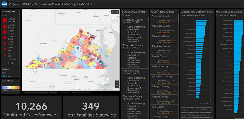
Social distancing is considered one of the key factors in slowing the spread of coronavirus, and a new interactive, county-by-county map of Virginia makes it possible to see how well people are following stay-at-home orders and physical distancing guidelines.
Michael Lippmann, co-founder of Arlington-based mapping solutions company Blue Raster, said the map integrates anonymous cellphone location data.
“For people in certain counties, their phone is staying very close to their home,” he said. “And that’s a signal showing they’re listening (to social distancing guidelines).”
In addition to charting county-by-county cases and hospital information in its Virginia COVID-19 Social Distancing Dashboard, the map includes social distancing data provided by Unacast, which compares the amount of traveling a person’s phone is doing now to before stay-at-home orders were in place.
“Think of a person who sticks close to home — maybe they go for a walk down the block to get some fresh air — versus a person who decides they’re going to just live their life as they always did, and just drives around everywhere,” Lippmann said.
While the numbers and ratings can change with continuous updates, on Thursday morning, the city of Alexandria scored an “A” in Daily Travel Distance, which shows a decrease of more than 70%. By comparison, Fauquier County’s “D” indicates people’s phones are traveling 25% to 40% less.
In addition to compiling how far phones travel from home, the dashboard also looks at where the phone — and likely, its owner — is traveling.
In the Unacast data’s Non-Essential Travel Score: “If a person is traveling to a grocery store, that is scored well. But if you’re driving to something that is classified as non-essential, that’s where those scores start to decrease,” Lippmann said.
After responding to a request to all Virginia businesses for assistance from Gov. Ralph Northam, Blue Raster was contacted by the Virginia Economic Development Partnership, and showed examples of coronavirus maps they had provided to the American Red Cross and FEMA in Nevada.
Lippmann, a small business owner, said Blue Raster employees developed the resource from home by teleworking.
“It’s been amazing using all the technologies, from Zoom to Microsoft Teams, and having so many different cloud services available.”
As government and public health leaders have monitored and developed policies, “location intelligence and geospatial has really been key to this pandemic,” Lippmann said. “Almost everyone has seen the Johns Hopkins dashboard, which is built on the Esri ArcGIS software that we use.”
Chris Gabris, Blue Raster’s project manager, said the dashboard can help support federal, state and local governments “in their efforts to analyze, visualize, and share important and timely information,” as “focus shifts to recovery and reopening.”
- Sign up for news alerts from WTOP
- Md. sixth grader helps create 1,000 masks for nurses, first responders
- How to help during the pandemic
- VA medical facilities struggle to cope with coronavirus
- Latest coronavirus test results in DC, Maryland and Virginia
- Coronavirus resources: Get and give help in DC, Maryland and Virginia
- Social distancing leaves some DC-area doctors with quiet practice