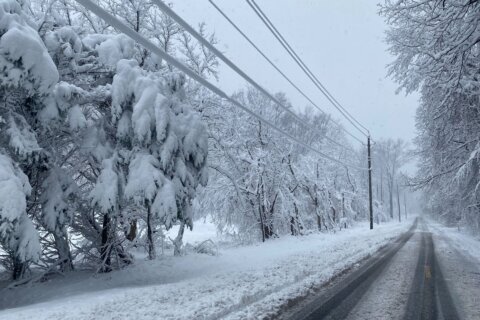
There’s a small chance for light snowfall during the Wednesday evening commute in the D.C. area, potentially adding to the existing challenges on the roadways left behind by the weekend’s winter storm.
The National Weather Service said there’s a 30% chance of light snow on Wednesday, with the highest likelihood being between 5 p.m. and 9 p.m.
“We’re looking at another shot of cold air on the way for tonight, may bring a few snow showers or flurries, though I am not expecting a whole lot,” said 7News First Alert Meteorologist Steve Rudin.
If those flurries come through, the D.C. region could see anywhere from a coating to a half inch of snow, according to NWS.
Any potential snowfall could make driving on untreated roads dangerous as leftover snow and ice from the weekend’s major snowstorm linger on roadways.
We are monitoring a chance (20-30 percent) for light snow to move through the areas highlighted in green from northwest to southeast later this afternoon into this evening. If the snow occurs, a coating to around a half of an inch could be possible during the PM commute. pic.twitter.com/NuWBSYsHuG
— NWS Baltimore-Washington (@NWS_BaltWash) January 28, 2026
The snow and ice is here to stay for a quite a while. The D.C. area may see a nine-day stretch of subfreezing temperatures.
The bitter cold continues with highs only reaching the mid-20s Wednesday.
7News First Alert Meteorologist Eileen Whelan said snow and ice will be “slow to melt” over the next few days. Roads and sidewalks could refreeze quickly once the sun goes down, keeping travel tricky through the end of the week.
“I don’t see highs getting above 32 degrees until Monday of next week. Clouds will build heading into the evening hours and then clear overnight,” Whelan said. “Watch out again tonight for a refreeze.”
A cold weather advisory is in effect overnight; Whelan said wind chills could reach 8 below zero Thursday morning.
The District hasn’t seen a long streak of cold weather like this since December 1989, Whelan said.
Bundle up in layers, especially if you’re walking anywhere. Many pedestrian walkways and paths are still being cleared.
There could be more winter weather over the weekend.
“All eyes are on a coastal storm that’s expected to intensify rapidly off the North Carolina coastline,” Rudin said.
Based on recent forecast models, Rudin said the storm will stay far enough east to limit potential impacts in the D.C. region.
“However, if you do have plans that take you to Delmarva over the weekend, or the Outer Banks of North Carolina, could be a big winter weather maker,” Rudin said.
- Listen to WTOP online and on the radio at 103.5 FM or 107.7 FM.
- Current traffic conditions
- Weather forecast
- Closings and Delays
- Sign up for WTOP email alerts
Closures and Metro schedule changes
Metrorail service will operate on a weekend schedule, with trains running every 15 to 30 minutes. Metro said service frequency is expected to increase throughout the day.
Check WMATA’s website before traveling for route-specific service information.
Many schools and offices across the D.C. region will be closed Thursday as cleanup from the weekend storm continues. See the full list of closures.
Forecast
WEDNESDAY EVENING:
Scattered snow showers. Light accumulation possible
Highs: 20s
Winds: Northwest 5-15 mph
OVERNIGHT:
COLD WEATHER ADVISORY
Scattered clouds
Lows: 0-8
Wind Chills: -10 to 0
Winds: Calm
THURSDAY:
Partly cloudy
Highs: 23-28
Winds: Northwest 5-15 mph
THURSDAY NIGHT:
Mainly clear
Lows: 0-8
Wind Chills: -10 to 0
Winds: West 5-10 mph
FRIDAY:
Partly cloudy
Highs: 23-28
Winds: Northwest 5-15 mph
WEEKEND OUTLOOK: The overall pattern looks favorable for a winter storm setup along the East Coast this weekend, based on how similar setups have behaved in the past. The big-picture ingredients are there — but in a pattern this sensitive, the final outcome still comes down to the details. Forecast guidance is still hinting at a more organized coastal storm, but there’s also a realistic chance it stays mostly offshore and never really locks in. That’s why the next day or two of updates will matter, as newer data helps the models handle the setup more confidently.
Get breaking news and daily headlines delivered to your email inbox by signing up here.
© 2026 WTOP. All Rights Reserved. This website is not intended for users located within the European Economic Area.