WASHINGTON — Those ready for a break from the blast of winter weather this past week won’t see any relief over the weekend. Forecasts predicted yet another round of snow headed to the D.C. area.
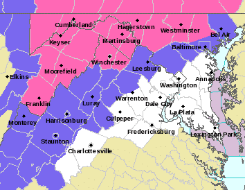
The National Weather Service has issued a Winter Storm Warning for Baltimore, Carroll, Frederick and Washington counties in Maryland from 10 a.m. Saturday to 6 a.m. Sunday, with significant ice, snow and some sleet expected.
A Winter Weather Advisory has been issued for Fauquier and Loudoun counties in Virginia, and Montgomery and Howard counties in Maryland starting 10 a.m. Saturday.
Rain with a wintry mix in spots moves in midday Saturday, said Storm Team 4 meteorologist Amelia Draper. “Some minor flooding possible later Saturday, then an arctic blast of dangerously cold air arrives later Sunday into Monday.”
- Listen to WTOP online and on the radio at 103.5 FM or 107.7 FM.
- Current traffic conditions
- Weather forecast
- Closings and delays
- Sign up for WTOP alerts
Latest snowfall, ice accumulation, and total precipitation forecasts for the upcoming weekend storm. pic.twitter.com/O3weym4BW1
— NWS Eastern Region (@NWSEastern) January 18, 2019
Draper said for those under the Winter Storm Warning, she was most concerned for a period of freezing rain during the day Saturday. “Temperatures in the warning (area) will be right around freezing, and with warmer air aloft, we could see some ice develop as precipitation falls,” she said.
She added that snow was possible, but only around 2 inches or less.
“If you can avoid travel tomorrow around I-81 and the Mason-Dixon Line, that is your best bet. In the D.C. metro area and east, roads should be just wet, not slick,” Draper said.
The temperatures Saturday are expected to be in the upper 30s to low 40s.
Rain is expected to continue Sunday, turning into snow in the early with rapidly falling temperatures. The temperatures are expected to be in the low 40s in the morning, falling to below freezing by the afternoon to in the 20s and below in the evening.
“Temperatures will fall below freezing Sunday afternoon, leading to icy spots on our roadways,” Storm Team 4 meteorologist Mike Stinneford said.
Monday is expected to be “blustery and very cold,” said Storm Team 4 meteorologist Matt Ritter. The highs are in the 20s for Monday with wind chills below zero for much of the day.
FORECAST
SATURDAY: Rain, wintry mix in spots, moves in 10 a.m. to 3 p.m. Becoming all rain overnight with some minor flooding possible. Watch for ice and snow concerns well north and west of the District.
Highs: near 40SUNDAY: Rain/mix ends by morning. Windy and turning colder. Icy spots possible overnight.
Highs: 40s, falling into the 20s by sunsetMONDAY/Martin Luther King Jr. Day: Dangerously cold. Mostly sunny and windy.
Highs: low to mid-20sTUESDAY: Partly sunny and not as cold.
Highs: low to mid-30s