Workweek weather: Off to chilly start; mostly quiet

(Storm Team 4)
The scenario for the new workweek is a bit like last week, inasmuch as there will be some temperature swings. But it also looks like a quiet week, with no big storms and a lot of uneventful weather. (WTOP/Storm Team 4)
The following images show the daily trend of temperatures for the week and the big swings day to day. Monday starts out chilly. Tuesday’s a little milder (more seasonable). Wednesday’s warm. Thursday is also most likely warm but notice the big temperature contrast in the region; that will be because of the progression of the cold front. Friday’s chilly again. The data is from the American Global Forecast System model run Sunday morning. (Data: Environmental Modeling Center, NOAA. Graphics: Storm Team 4)
The following images show the daily trend of temperatures for the week and the big swings day to day. Monday starts out chilly.   (Data: Environmental Modeling Center, NOAA. Graphics: Storm Team 4)
(Data: Environmental Modeling Center, NOAA. Graphics: Storm Team 4)
Tuesday’s a little milder (more seasonable). (Data: Environmental Modeling Center, NOAA. Graphics: Storm Team 4)
(Data: Environmental Modeling Center, NOAA. Graphics: Storm Team 4)
Wednesday’s warm.   (Data: Environmental Modeling Center, NOAA. Graphics: Storm Team 4)
Thursday is also most likely warm but notice the big temperature contrast in the region; that will be because of the progression of the cold front. (Data: Environmental Modeling Center, NOAA. Graphics: Storm Team 4)
(Data: Environmental Modeling Center, NOAA. Graphics: Storm Team 4)
Friday’s chilly again. The data is from the American Global Forecast System model run Sunday morning. (Data: Environmental Modeling Center, NOAA. Graphics: Storm Team 4)
The total precipitation forecast from the Weather Prediction Center division of NOAA shows the trend, that just like last week, copious amounts of rain and mountain snows will move into the Pacific Northwest and we will have to wait for the cold front to get here Thursday/Thursday night, but it won’t amount to much rain. (Weather Prediction Center, NOAA)
(1/7)
(Storm Team 4)
The following images show the daily trend of temperatures for the week and the big swings day to day. Monday starts out chilly. Tuesday’s a little milder (more seasonable). Wednesday’s warm. Thursday is also most likely warm but notice the big temperature contrast in the region; that will be because of the progression of the cold front. Friday’s chilly again. The data is from the American Global Forecast System model run Sunday morning. (Data: Environmental Modeling Center, NOAA. Graphics: Storm Team 4)
(Data: Environmental Modeling Center, NOAA. Graphics: Storm Team 4)
The total precipitation forecast from the Weather Prediction Center division of NOAA shows the trend, that just like last week, copious amounts of rain and mountain snows will move into the Pacific Northwest and we will have to wait for the cold front to get here Thursday/Thursday night, but it won’t amount to much rain. (Weather Prediction Center, NOAA)

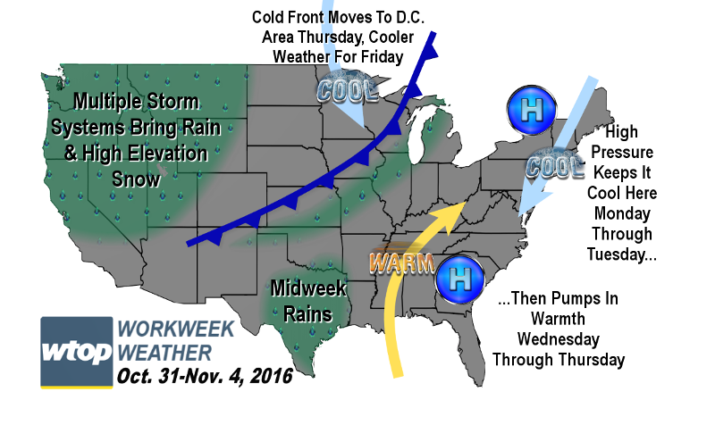
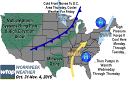
WASHINGTON — The scenario for the new workweek is a bit like last week, inasmuch as there will be some temperature swings. But it also looks like a quiet week, with no big storms and a lot of uneventful weather.

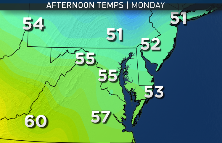
High pressure that pushed Sunday’s strong cold front through will now be giving us cool, northerly winds all day Monday, making it feel much more like it’s Halloween. The center of the high will wedge its way down the eastern seaboard, keeping us mainly dry except for a slight chance of drizzle Tuesday on easterly flow off the ocean and the bay.

Ultimately, the high will set up a broad southwesterly wind flow when the high’s center shifts to our south and east, just off the coast. This will give us another big warmup in the middle of the week.

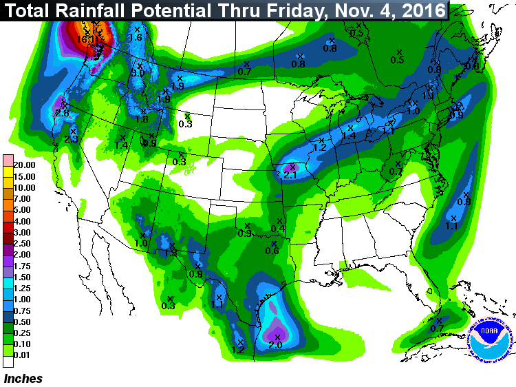
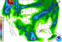
Repetitive storms will be slamming into the Pacific Northwest bringing lots of rain and mountain snow. Some of that energy will swing a cold front our way near the end of the week but only with a chance for light showers. At this point, it’s uncertain how quick the front will be, and that will be crucial because it either means a very warm or a typically cool autumn Thursday.

Unlike last week, the cooler weather behind the front will stick around for several days in a row as the pattern becomes blocked over the north Atlantic. Once again, unfortunately, in this weather pattern there are no big rainmaking storms heading our way and our rainfall deficit will continue to grow.

Daily weather highlights
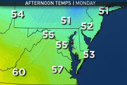
Monday

  • Chilly start
  • Sun goes in and out of fluffy cumulus clouds
  • Breeze makes it feel chilly
  • Temperatures in the low 50s during trick-or-treat
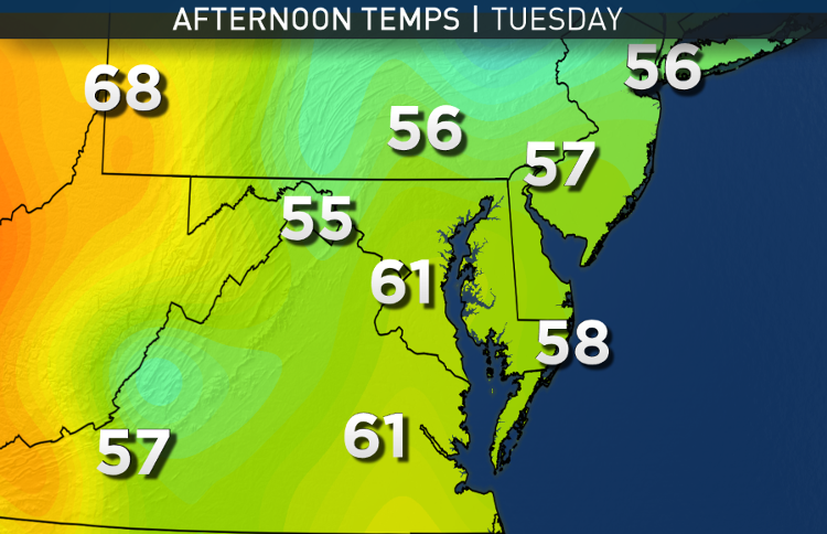
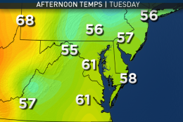
Tuesday

  • Cool start with some patchy fog possible and even some drizzle
  • Winds change from northerly to southeasterly
  • Milder and more seasonable than Monday
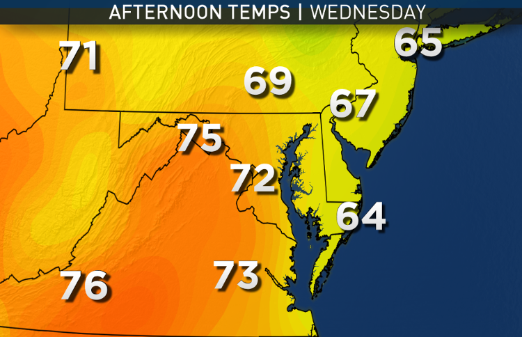
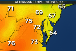
Wednesday

  • Mild start with some patchy fog
  • Mostly sunny skies with thin, high-level clouds
  • Temperatures several degrees above average
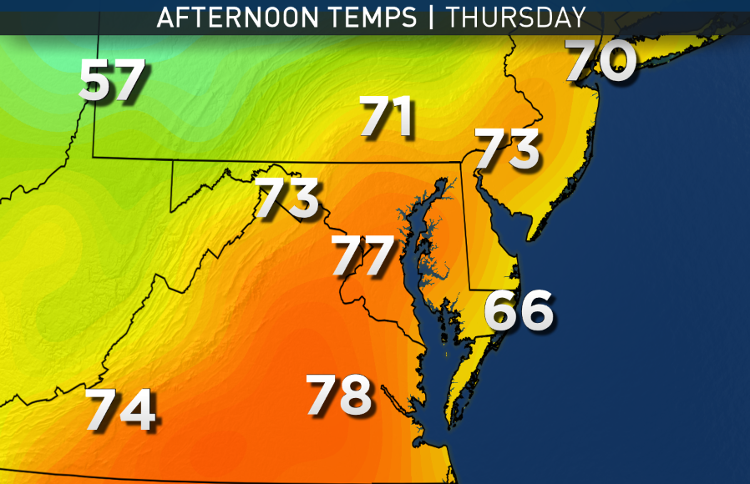
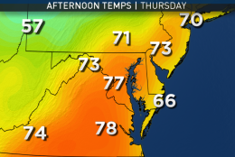
Thursday

  • Warm start much like this past Sunday
  • Uncertainty regarding how much warmer it gets compared to morning temperatures depending on front’s speed and arrival of showers
  • Potential to have very warm temperatures if front is slow and showers wouldn’t arrive until the end of the day
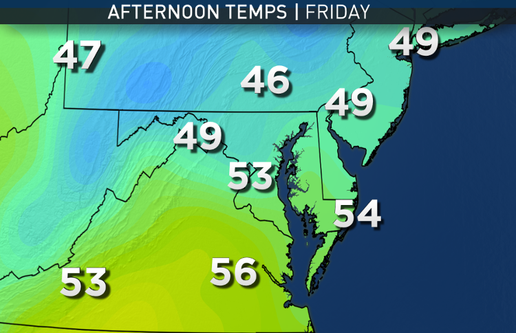
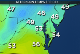
Friday

  • A near repeat of Halloween Monday’s weather: Breezy and chilly

Editor’s Note:  The WTOP Workweek Weather Blog is intended as an in-depth yet plain language summary of the business week’s weather potential in the D.C., area along with an explanation of the contingencies and uncertainties that exist at the time of publication. For the latest actual Storm Team 4 Forecast, check out the WTOP weather page.

Federal News Network Logo
Log in to your WTOP account for notifications and alerts customized for you.

Sign up