WASHINGTON — Sunday in the D.C. region was gorgeous and Monday morning was similarly calm with light blue skies and cool temperatures.
But four years ago this week, the Washington area was hit by repeated tornadoes that were part of a cavalcade of storms that made April 2011 one of the deadliest months on record.
“April 2011 was one of the most active, destructive and deadly tornado months on record for the United States,” according to the National Climatic Data Center. And once I started digging into it, I could understand just how true this statement is.
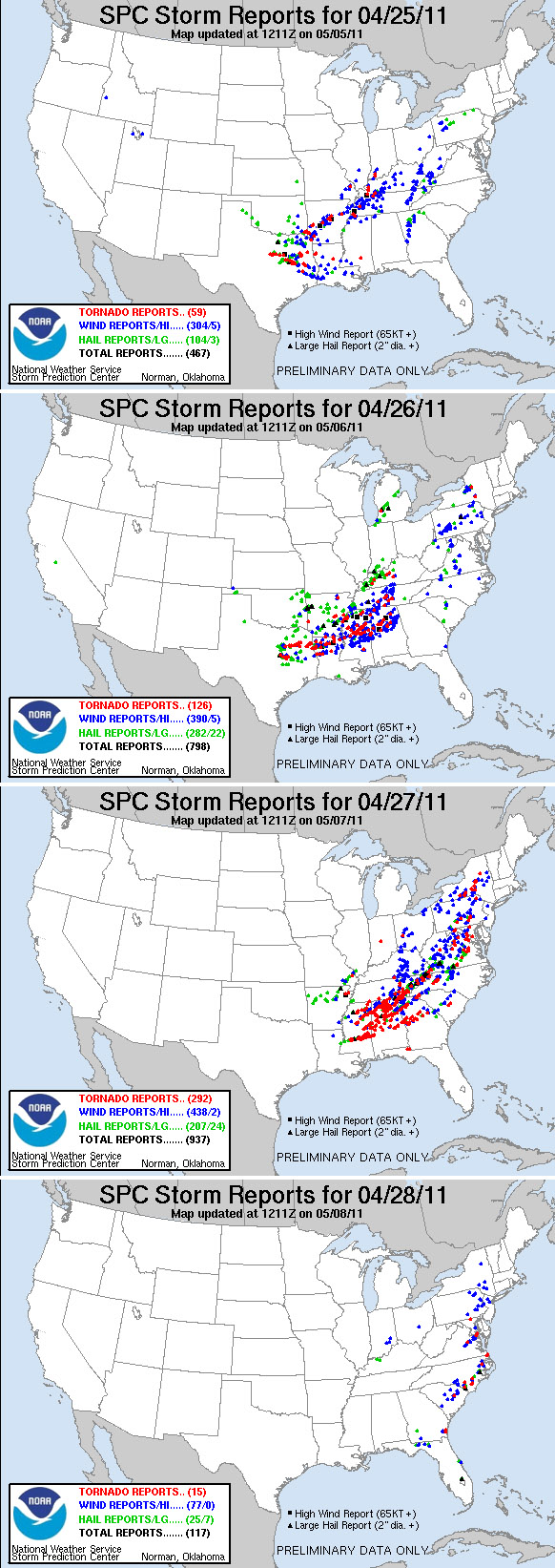
The outbreaks lasted from April 25 to April 28. In the span of a few days, there were 875 confirmed tornado reports during this month across the United States, according to the Storm Prediction Center. The final tornado count for the month surpassed the all-time monthly record of 542 tornadoes set in May 2003. The average for the month of April during the last 30 years is about 135 tornadoes.
At the time, I realized that April 2011 was an extremely terrible month for severe weather. But I had forgotten until I started researching a little deeper just how bad the month was. In fact, just four years ago from Monday, the area added to the most tornadoes in one month stat in the United States.
Here in the D.C. area, in less than 24 hours, 19 tornadoes were confirmed between April 27 and April 28. This was the tail end of one of the largest, deadliest and most destructive tornado outbreaks in U.S. history.
This outbreak was the perfect storm. Everything came together in perfect harmony to produce an outbreak that injured 2,400 people and killed 321 people, including four in Virginia. This storm also totaled more than $4.2 billion in damage.
All the fatalities occurred within the areas where tornado watches and eventually tornado warnings had been issued. The NWS service outlets did an excellent job as the lead time (the time from when watches were issued to when the first tornadoes entered the watch area) were on par with about three to six hours. Warnings gave residents 22.1 minutes on average across the United States. The average lead time for the local NWS office was 11 minutes.
On April 25, a very intense upper level trough moved into the Southern Plains. This eventually interacted with an area of low pressure that was hanging out over portions of Oklahoma and Missouri. April 26 proved to bring a similar atmospheric set up and produced severe weather with daytime heating and added tropical moisture across the Gulf States including Texas, Louisiana, Arkansas and Mississippi.
Pieces of energy aloft would eject out of the trough and created surface waves that only added to the severe weather outbreak. Eventually, the main area of low pressure that was over Oklahoma and Missouri lifted north and east toward the Ohio Valley.
A strong jet stream lent to very strong wind shear (winds changing directions and speed with height), which is a key ingredient for the formation of tornadoes. During the four days, (especially April 27), wind speeds at the surface were running about 20 mph or greater. Wind speeds reached 70 mph or greater at 3,000 feet into the atmosphere and more than 100 mph at times at about 34,000 feet into the atmosphere — this scenario creates the high potential for strong, low-level rotation in developing storms.
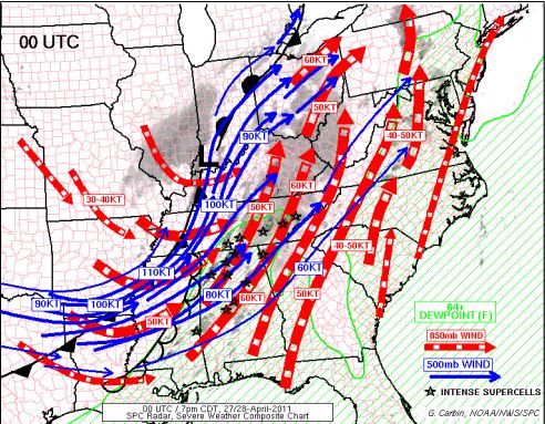
On April 27, the last of several upper-level storms moved east out of the southern Rockies. The air associated with these particular storms was much colder than previous storms, which led to very quick destabilization of the atmosphere. Low pressure was situated over the Ohio Valley, the attendant cold front started pushing eastward, tapping into the already extremely unstable atmosphere. Severe weather started creeping east in two waves from Arkansas, Georgia, the Carolinas to Tennessee, Virginia and Maryland from April 27 to early April 28. Through April 28, the storm system continued to move eastward toward the eastern seaboard.
The most destructive tornado ripped through Tuscaloosa, Alabama, on April 27. Winds of 190 mph were reported with a tornado that had a 1.5 mile-wide base. There were 65 fatalities associated with this particular EF4 tornado, which traveled more than 80 miles and caused more than 1,000 injuries.

The D.C. area really didn’t see any severe weather until the evening of April 27 around 6:15 p.m. That is when the first of 19 tornadoes touched down. A weather observer reported it at Quantico Marine Corps Base.
The tornado formed southeast of Triangle, Virginia, as an EF0 with winds around 65 mph. It was on the ground for seven minutes and covered about 2 miles through Stafford and Prince William counties. This particular tornado swirled around tree debris, but did no other damage. Eventually the storm that produced this tornado traveled into the Potomac River and eventually into Maryland where three more EF0 tornadoes formed.
The atmosphere then proceeded to produce the other tornadoes in our area with the last reported touching down about 11:41 a.m. on April 28.
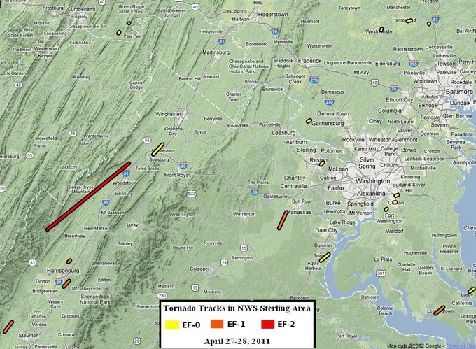
The biggest tornado in our area moved through portions of the Shenandoah Valley in Rockingham and Shenandoah counties from Fulks Run to St. Luke. It traveled 33.2 miles and the path was 400 yards wide! Winds approached upward of 130 mph during its duration from 2:12 a.m. until 2:41 a.m. It was classified as an EF2 by the local weather service office after the damage was surveyed. Two people suffered minor injuries — the only injuries reported during the two-day spat of tornadoes.
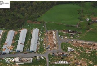
Most of the damage around our region was to houses or other structures as well as uprooted trees. It took more than two weeks for local weather service staff to survey areas suspected of having tornado damage.

The local office issued 38 tornado warnings during those two days, which still ranks No. 2 for the total number of tornado warnings issued with a single storm. More were issued Sept. 17, 2004 when the weather service in Sterling issued 43 tornado warnings in a six hour period as the remnants of Tropical Storm Ivan pushed through the region.
Source: Historical weather data from National Weather Service Storm Prediction Center, National Climatic Data Center, and Weather Prediction Center.