Workweek Weather: Irma remnants to bring showers to DC

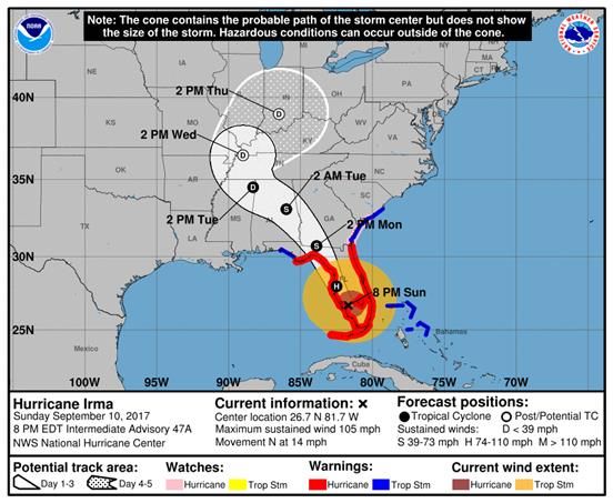
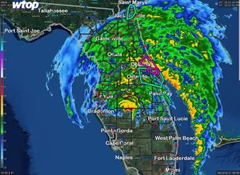
WASHINGTON — All eyes are understandably still on Irma early this morning as it appears the center will continue to move right up the middle of the Florida peninsula, or at least hug the western shoreline.

The center staying mostly or completely over land will ensure a rapid weakening in terms of wind speeds, but torrential rains will continue to fall all the way up into the majority of Georgia and South Carolina.

The official track from the National Hurricane Center continues to have it turning a bit toward the West as it moves farther inland, followed by a very rapid weakening to a tropical storm and then tropical depression, followed by the storm’s remnants in the Tennessee and Ohio Valleys.

As this process happens, the eastern spiral bands will be heading our way, tapping Atlantic moisture, bringing us some substantial showers in their own right. However, we are not looking at very heavy rain or anything close to what one might expect from a tropical connection.

By Monday afternoon the storm should be reduced to tropical storm strength, weakening to a depression by Tuesday afternoon. For the latest National Hurricane Center information, visit the National Hurricane Center. (Courtesy NHC, NOAA)

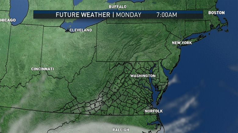
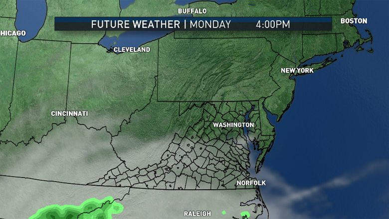
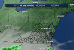
High pressure which brought the cool, dry weather for several days here in the D.C. area and most of the Northeast will finally be heading out to sea, steering Irma inland. Lots of high level clouds from the edge of the system will be moving overhead on Monday and Monday night.

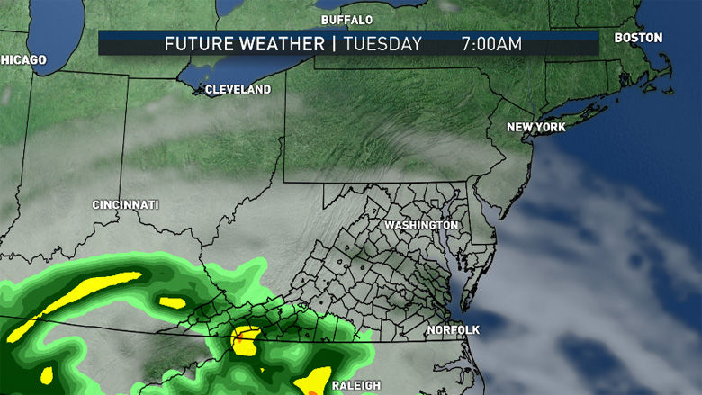
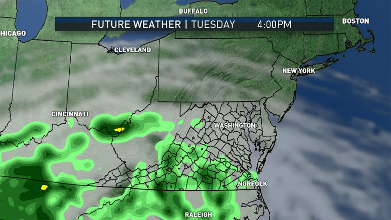
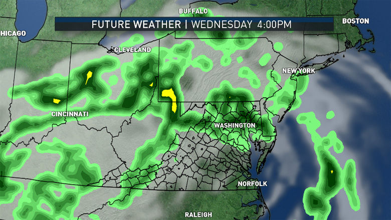
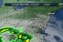
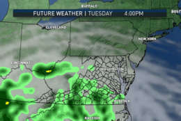
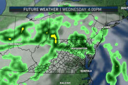
On Tuesday, we’ll start to see some of the final spiral band remnants approaching. Showers could be here as soon as the afternoon; keep in mind these will be showers with an occasional thunderstorm but not a large area of steady, heavy rain. These showers will continue into Tuesday night and Wednesday.

National Weather Service radar from Melbourne, Florida, showing the center of Irma moving into Polk County. Flash Flood and Tornado Warnings up along the coast at the time. (WTOP/Storm Team 4)

The forecast for the rest of the week is a little trickier. The exact center in the Ohio Valley will have to shear apart and drift east. Most longer range computer models bring those remnants through our area again starting on Thursday. But if the center of low pressure moves a little farther north toward the Great Lakes, then we would likely just see mostly cloudy, breezy, warm and humid conditions.

That possibility is just an outlier in a realm of reasonable solutions, and right now Storm Team 4 believes we will get more showers and some thunderstorms Thursday and Friday.

Hurricane Jose will head back out to sea in this time period – at least temporarily. Many long range computer models “loop” it back toward North America but not necessarily making landfall. If our area were to experience Jose in any way, it would take more than a week from now.

Daily weather highlights:
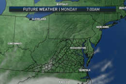
MONDAY:
• Sunny and cool to start the day
• Increasing high level “whispy” clouds, lowering and thickening later in the day
• Temperatures again below average (low 80s this time of year)

TUESDAY:
• Mostly cloudy
• Breezy, more humid but still unseasonably cool
• Showers and possible thunderstorms scattered around and arriving later in the day
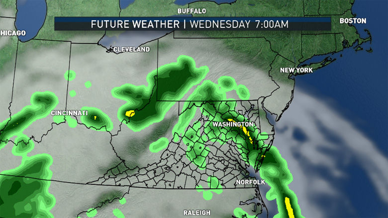
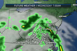
WEDNESDAY:
• Mostly cloudy
• Breezy, much warmer and humid
• Scattered showers and possible thunderstorms

THURSDAY and FRIDAY:
• Cloudy, breezy, warm and humid
• Showers and thunderstorms
• Amount of showers and thunderstorm coverage depending on track of final remnants of Irma

This series of images are from the RPM computer model initialized Sunday evening, lasting through Wednesday morning. It shows the potential future satellite and radar for our area. Clouds in gray overspread the area on Monday and the eastern spiral bands (light to dark green to yellow) of Irma’s remnants starting moving through on Tuesday, lasting through Wednesday. On the left side of the graphics on Wednesday will be the center of what’s left of the storm. It will drift eastward the rest of the week. (Data: The Weather Company. Graphics: Storm Team 4)
This series of images are from the RPM computer model initialized Sunday evening, lasting through Wednesday morning. It shows the potential future satellite and radar for our area. Clouds in gray overspread the area on Monday and the eastern spiral bands (light to dark green to yellow) of Irma’s remnants starting moving through on Tuesday, lasting through Wednesday. On the left side of the graphics on Wednesday will be the center of what’s left of the storm. It will drift eastward the rest of the week. (Data: The Weather Company, Graphics: Storm Team 4)
These amounts of rain could double if the final remnant low pressure center moves directly over us Thursday-Friday. (WTOP/Storm Team 4)
This series of images are from the RPM computer model initialized Sunday evening, lasting through Wednesday morning. It shows the potential future satellite and radar for our area. Clouds in gray overspread the area on Monday and the eastern spiral bands (light to dark green to yellow) of Irma’s remnants starting moving through on Tuesday, lasting through Wednesday. On the left side of the graphics on Wednesday will be the center of what’s left of the storm. It will drift eastward the rest of the week. (Data: The Weather Company, Graphics: Storm Team 4)
(1/7)
This series of images are from the RPM computer model initialized Sunday evening, lasting through Wednesday morning. It shows the potential future satellite and radar for our area. Clouds in gray overspread the area on Monday and the eastern spiral bands (light to dark green to yellow) of Irma’s remnants starting moving through on Tuesday, lasting through Wednesday. On the left side of the graphics on Wednesday will be the center of what’s left of the storm. It will drift eastward the rest of the week. (Data: The Weather Company. Graphics: Storm Team 4)
This series of images are from the RPM computer model initialized Sunday evening, lasting through Wednesday morning. It shows the potential future satellite and radar for our area. Clouds in gray overspread the area on Monday and the eastern spiral bands (light to dark green to yellow) of Irma’s remnants starting moving through on Tuesday, lasting through Wednesday. On the left side of the graphics on Wednesday will be the center of what’s left of the storm. It will drift eastward the rest of the week. (Data: The Weather Company, Graphics: Storm Team 4)
These amounts of rain could double if the final remnant low pressure center moves directly over us Thursday-Friday. (WTOP/Storm Team 4)
This series of images are from the RPM computer model initialized Sunday evening, lasting through Wednesday morning. It shows the potential future satellite and radar for our area. Clouds in gray overspread the area on Monday and the eastern spiral bands (light to dark green to yellow) of Irma’s remnants starting moving through on Tuesday, lasting through Wednesday. On the left side of the graphics on Wednesday will be the center of what’s left of the storm. It will drift eastward the rest of the week. (Data: The Weather Company, Graphics: Storm Team 4)

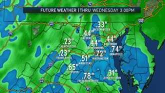
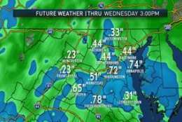
The output from the same run of the RPM shows rainfall amounts for our area over half an inch through Wednesday afternoon, the exact placement will depend on exactly where the spiral bands of showers move.

These amounts could double if the final remnant low pressure center moves directly over us Thursday-Friday.

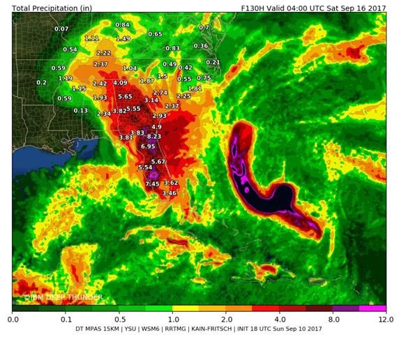
IBM’s experimental new weather forecast model, Deep Thunder, shows what can be expected: torrential rain through northern Florida tapering to “regular” heavy rain as the center moves through Georgia into the Tennessee and Ohio Valleys, tapering to showers.

This graphic is a running total starting Sunday afternoon ending this Friday at midnight. The dark colors out to sea are from Jose, and note the turn west then north, paralleling the coast.

A look at the running total starting Sunday afternoon ending Friday at midnight. (Courtesy The Weather Company/IBM)

IBM is the parent company of The Weather Company.

Editor’s Note: The WTOP Workweek Weather Blog is intended as an in-depth yet plain language summary of the business week’s weather potential in the D.C. area along with an explanation of the contingencies and uncertainties that exist at the time of publication. For the latest actual Storm Team 4 forecast, check out the link on the main WTOP Weather Page.

Federal News Network Logo
Log in to your WTOP account for notifications and alerts customized for you.

Sign up