New plans for rapid bus stations and bus lanes along Route 7 in Northern Virginia show the changes that could come to the busy commuter route over the next decade.
A new conceptual engineering report lays out 18 specific bus rapid station locations from Tysons to Alexandria. It also details the spots where buses would have their own lanes in the middle of the road or on the outside of the road, and where buses would share lanes with car traffic.
The Northern Virginia Transportation Commission formally accepted the report Thursday night.
“We’d all ideally love to see something in the next five to 10 years, but there’s lots of decisions and lots of public input that is going to go on before that time,” NVTC Executive Director Kate Mattice said in an interview.
The project is estimated to cost around $350 million in today’s dollars, which is projected to equate to $450 million to $500 million in 2030, since no new bridges are expected to be needed.
Those costs include planned widening of Route 7 in some areas that will be used to add bus lanes, but do not include bus purchases, any new maintenance facility or ongoing operations.
The designs also indicate where up to 100 properties could have a sliver of land or more taken for the project. None of those locations are finalized at this stage, and further designs could reduce the impact.
The areas with the most significant impacts could be Tysons, Pimmit Hills, Seven Corners and Bailey’s Crossroads.
The corridor runs from Alexandria’s West End Transitway through the Mark Center, Bailey’s Crossroads, Seven Corners and Falls Church, to Fairfax County’s Spring Hill Metro in Tysons.
By narrowing down construction plans now, development can be focused near stations to reduce extra traffic.
“The idea is getting ahead of land-use decisions so that we can look at maximizing that bus rapid transit,” Mattice said.
Design details
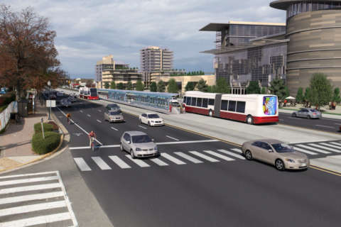
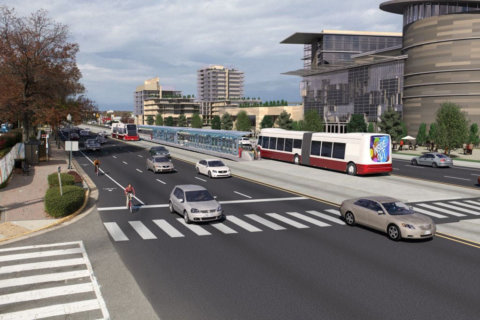
Though it remains early in the process, the specific recommended station designs and roadway layouts mark another significant milestone in development of the improved transit system.
The busiest station is projected to be at the East Falls Church Metro station, where more than 10,000 people per day are projected to get on buses, mainly to transfer to the Orange or Silver lines.
Though the study concludes bus-only lanes the entire way would be best, traffic pressures and existing buildings make that impractical.
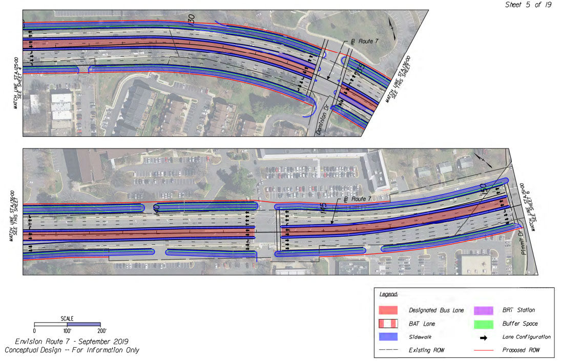
Route 7 would get bus-only lanes from Tysons to Falls Church and from Seven Corners to Beauregard Street. In areas such as Falls Church, the study recommends “BAT lanes” — lanes marked as bus-only but that would also allow car traffic to turn in and out of driveways.
There would also be some spots where buses would simply sit in regular traffic in order to largely keep existing lanes and turn options for drivers in most spots.
New sidewalks would be added in places near stations that do not have them today.
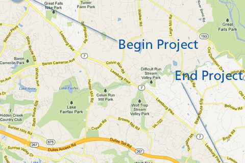
The design focuses on 10.5 miles from Spring Hill to N. Beauregard Street in Alexandria. Separately, Alexandria is planning the West End Transitway that will also be a part of the bus rapid transit system.
Bus stations would likely include locations to pay for trips, trash cans, real-time arrival information and other features.
Stations
Tysons
In Tysons, stations would be near the Spring Hill Metro, the Greensboro Metro and at Fashion Boulevard.
The number of people living and working near those stops is expected to jump dramatically over the next 20 years.
The station at Fashion Boulevard was initially considered for International Drive, but was shifted due to safety concerns with all of the cars at the intersection.
The route of the bus line in Tysons could change further under an ongoing Fairfax County study. The county is making a number of changes in Tysons, such as adding a new street grid and plans to turn the Route 7/Route 123 interchange into a regular intersection in the future.
West Falls Church/Pimmit Hills — Capital Beltway to Haycock Road
Bus-only lanes would end near Idylwood Road with the shared BAT lanes picking up just past Interstate 66.
Stations are slightly farther apart in this area, with a focus on stops near Marshall High School, the Tysons-Pimmit Regional Library and George Mason High School.
The two stops would be at Dominion Drive near the library and Marshall High School, and near Chestnut Street by George Mason High School and the planned new development there.
Falls Church: Haycock Road to Washington Street
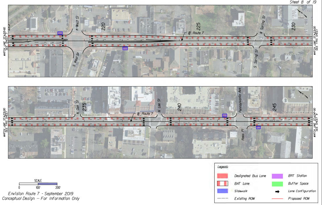
In downtown Falls Church, the tight space means buses could share lanes with cars in BAT lanes.
Stops would be at West Street, Pennsylvania Avenue and Maple Avenue.
This area could see more changes during later designs to examine different ways to create bus-only lanes as new development is built along Route 7.
East Falls Church: Washington Street to south Seven Corners
The route from Falls Church through Seven Corners relies on a future Ring Road Fairfax County plans to build in the Seven Corners area, connecting Wilson Boulevard and Route 7.
“The timing of delivery of the new Ring Road will be an important consideration for the BRT project,” the study said. “It is very likely that the (new) Ring Road may not be constructed prior to completion of the BRT project. An interim alignment will likely be necessary, which utilizes Wilson Boulevard and Route 7.”
There are four stations planned in this area: Jefferson Street and N. Washington Street, East Falls Church Metro, North Seven Corners and South Seven Corners.
East Falls Church is expected to be the busiest station. It would accommodate the existing bike lane, could have larger station platforms, and could even be moved to the I-66 flyover or into the Metro parking lot in future designs.
The North Seven Corners stop is a new recommendation in order to provide better access to the Eden Center and any future nearby development.
The South Seven Corners station would be on the new Ring Road and would be incorporated into any improved Seven Corners Transit Center.
Details of this stop are among the least nailed down, since Fairfax County still needs to finalize what roads will look like in the area.
Bailey’s Crossroads area: South Seven Corners to Beauregard Street
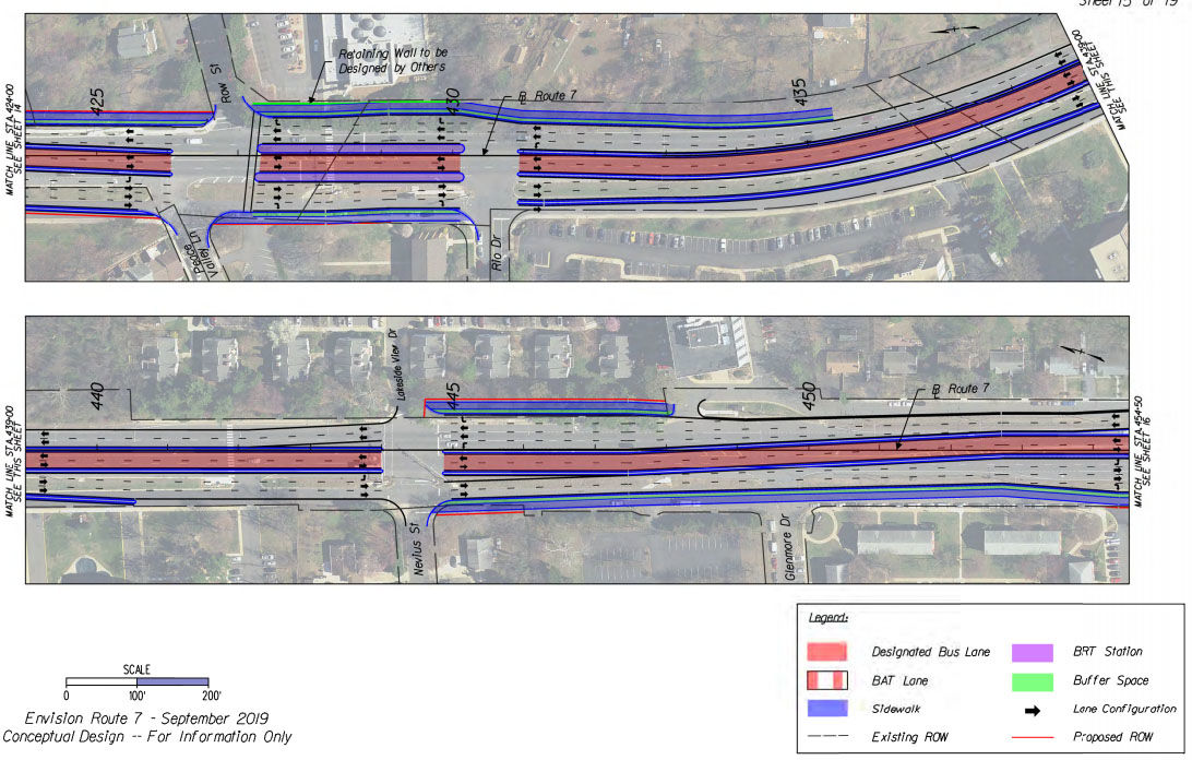
The service road in this area will be used to widen Route 7 to create space for bus-only lanes.
The Rio Drive Station will be in the center of the road between the Row Street and Rio Drive intersections. Though it is near Justice High School, the study suggests this station could be eliminated or combined with the Glen Carlyn station in future designs.
The Glen Carlyn station is proposed for about a half-mile east.
Another half-mile to the east, the Bailey’s Crossroads station would require reducing the number of turn lanes for car traffic. Future designs could shift it farther west away from the intersection in order to keep more lanes for cars.
The Crossroads Shopping Center Station at S. Jefferson Street is about 0.8 miles east of there.
The Beauregard Street Station at Route 7 and N. Beauregard Street would be the connection to the West End Transitway project.
West End Transitway: N. Beauregard Street to Mark Center
The buses will continue into Alexandria’s West End Transitway, but the city is not planning bus-only lanes there. Stops will also be closer together in this area than other parts of the route.
The E. Campus Drive/Braddock Road station is near the Northern Virginia Community College Alexandria Campus.
The Fillmore Avenue station would be on Beauregard Street near Fillmore Avenue
The Southern Towers station would be on internal roads in the complex, and the Mark Center station will begin using the existing transit center there.