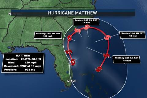
UPDATE (6 p.m. Oct. 8): The first operational Extreme Wind Warning was issued 5:26 a.m Friday by the National Weather Service for Brevard County, Florida during Hurricane Matthew.
WASHINGTON — Powerful Hurricane Matthew is expected to be a Category 4 storm with winds near 145 mph as it scrapes the east coast of Florida on Friday.
With potentially destructive winds affecting millions, it is possible that a unique and dire weather warning could be issued for the first time as the eye of the hurricane nears the coast.
Hurricane warnings are already in effect for much of coastal Florida and Georgia, but the first major hurricane to threaten the U.S. since Hurricane Wilma in 2005 may also prompt an “extreme wind” warning, said meteorologist Jessie Smith with the National Weather Service in Melbourne, Florida.
“We have not issued one here locally,” Smith said. “It’s there in our arsenal if we need it.”
An extreme wind warning indicates that the rapid onset of destructive winds is imminent.
The warning has never before been issued by any weather forecast office. Before 2006, the weather service actually issued tornado warnings for small geographic areas near the eyewall of hurricanes that made landfall in order to indicate dangerous winds — but that practice caused confusion since tornadoes were not expected.
The National Weather Service says an extreme wind warning is reserved for tornado-like wind damage that truly poses a significant threat of casualties.
An extreme wind warning was issued by error during a thunderstorm event in June 2009 but it was quickly redacted and replaced with a tornado warning.


