WASHINGTON — Hurricane Matthew, a possible hurricane for the record books, is brushing Florida in the early hours of Friday, and more than 2 million people have been urged to evacuate along the southeastern coast.
For the WTOP listening area, the effects will be pretty minimal. A trough of low pressure hangs off the Carolina coast with a lot of moisture forecast to surge up the coast from the hurricane. Rain showers and clouds will spread into the region for the second half of Friday as Matthew nudges north along the southeastern coastline.
The Nationals should be able to get in Game 1 of their playoff series, but getting Game 2 in on Saturday could be a problem: A frontal system will approach from the west, passing through the area on Saturday, and showers and light rain are likely for most of the day, particularly between 9 a.m. and 4 p.m.
Once the front moves through by Saturday and into Sunday morning, winds will really pick up — they could gust up to 30 mph, or even more, at times, making for a cool and windy day around the mid-Atlantic.
Forecasters will continue to monitor the track of Hurricane Matthew, especially into the next workweek. The track after Sunday continues to be a little murky, but, again, the impact around the mid-Atlantic area will be minimal.
IN THE SOUTHEAST, it’s a different matter.
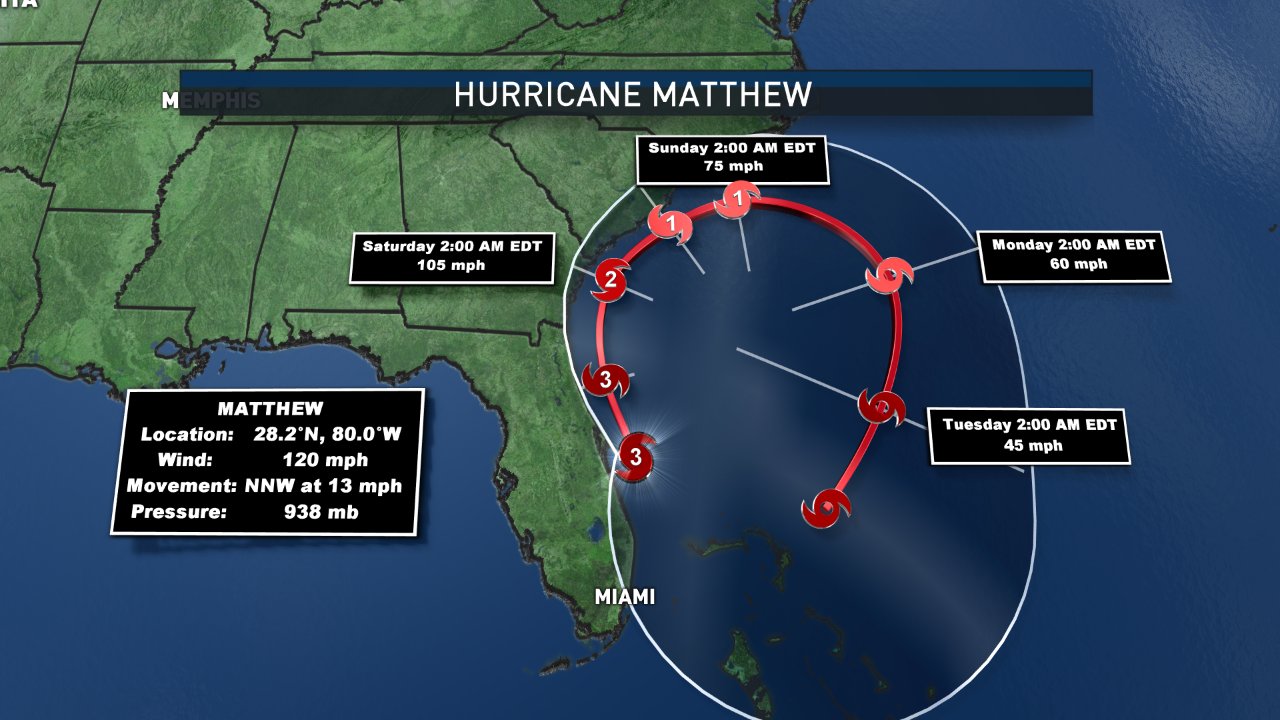
Matthew is now paralleling the Florida coast and is dangerously close to coming ashore. The western edge of the eye wall is brushing Cape Canaveral; wind gusts have reached 107 mph and wave swells have gone over 30 feet just offshore. The storm surge in the region is already at four feet.
The Florida, Georgia and South Carolina coasts need to remain vigilant and on high alert for coastal inundation, hurricane force winds, tornadoes and power outages. This is a dangerous storm with far-reaching implications. Hurricane warnings remain in place all the way north to Charleston, S.C., and Tropical Storm Warnings go all the way up the coast to Surf City, N.C.
Severe travel disruptions will continue to be a problem well into the weekend. The storm is still expected to hug the U.S. coastline all the way north to about Charleston, S.C., before turning back out to sea Saturday night. From there, the storm is expected to make a nearly complete circle while weakening down to tropical storm strength.
The storm could be back in the Bahamas by next Tuesday or Wednesday, and then re-threaten the Florida coast after that. We will watch it closely but the main takeaway is that we will be dealing with Matthew, in one form or another, for another week.
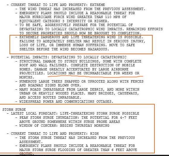
This is going to be a very dangerous hurricane with threats to life and property. In fact, Wednesday evening, the National Weather Service in Melbourne, Florida, issued a statement saying that a “life-threatening storm surge” was possible, and that some places “may be uninhabitable for weeks or months”: