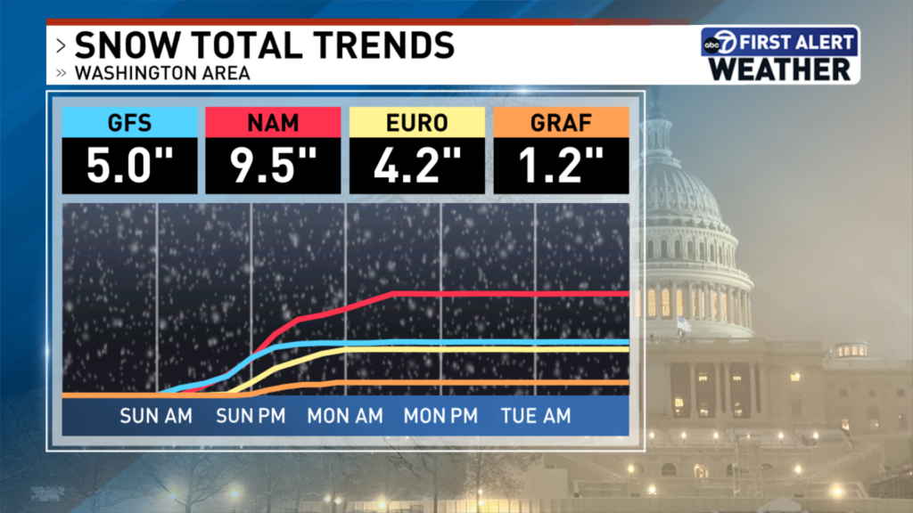
The D.C. region may see several inches of heavy snowfall on Sunday, with forecasts suggesting totals could be up to a foot in some parts of the area.
WTOP Meteorologist Mike Stinneford said there will be a “mix of rain and snow for much of the day” on Sunday, but he doesn’t expect it to impact travel and transportation until after sunset.
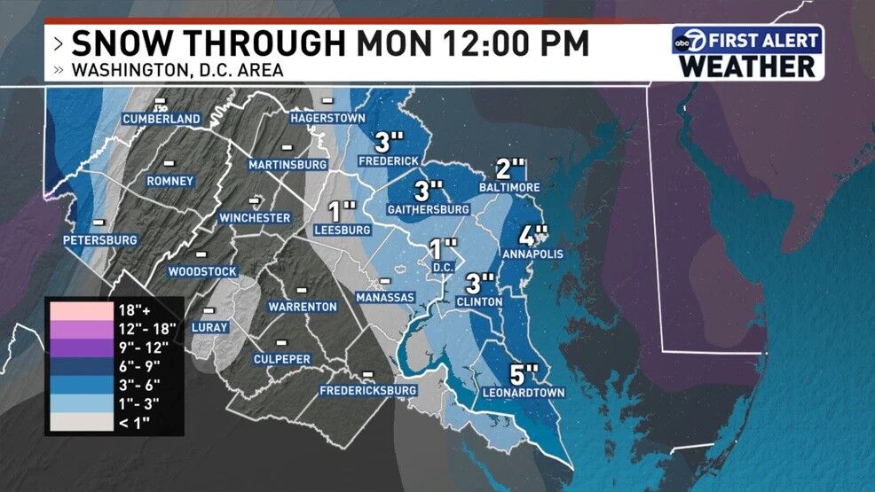
The D.C. metro area could receive between 3 to 6 inches of snow, while areas along and east of Interstate 95 could receive even more snow — between 6 to 12 inches.
As a result, a winter storm warning has been issued for the northern and eastern suburbs of the region and for southern Maryland from 3 p.m. Sunday until 10 a.m. Monday. Also, there will be a winter weather advisory for the rest of the area from 5 p.m. Sunday to 10 a.m. Monday.
7News First Alert Meteorologist Jordan Evans warned that reduced visibility is anticipated.
“We could see easily two to four, potentially up to five, inches of snow once we get into Sunday night and it’s out of here before the Monday morning commute,” Evans said, noting that the morning commute for the start of the week could be impacted by “slushy snowfall because of ground temperatures staying well above freezing.”
National Weather Service maps estimate most of the D.C. region will see between 1 to 3 inches of snowfall, but areas north and west of the D.C. metro could see 5 inches or more.
The NWS issued a winter storm watch beginning Sunday for parts of Frederick, Carroll, Baltimore, Montgomery, Howard counties in Maryland and Western Loudoun County, Virginia.
Some of the uncertainty about snow totals comes from a coastal storm that’s expected to develop off the coastline of North Carolina and South Carolina. Just how far east or west it develops could impact weather across the mid-Atlantic, 7News First Alert Meteorologist Steve Rudin said earlier.
- Listen to WTOP online and on the radio at 103.5 FM or 107.7 FM.
- Current traffic conditions
- Weather forecast
- Closings and Delays
- Sign up for WTOP email alerts
- Get custom alerts with the WTOP app for Apple and Android phones
Ahead of the anticipated snowfall, D.C. Mayor Muriel Bowser announced that her administration was activated a full deployment of the District Snow Team, with road crews starting to treat pavements with salt at noon on Sunday.
A cold alert has taken effect in the District, which will trigger the opening of a list of hypothermia shelters across the region. A winter storm watch is also in effect for Maryland’s Montgomery County from 3 p.m. Sunday to 10 a.m. Monday.
Most of the so-called ‘”snowcrete” has washed away after last month’s winter storm. A spokesperson with the Virginia Department of Transportation, Alex Liggitt, told WTOP that crews are holding off on pretreating the roads because forecast rain could wash away those efforts.
“Stay home if you can on Sunday and let allow us to get out there and do our job to try to get these roads cleared as quickly as possible,” Liggitt said.
FORECAST
WINTER STORM ADVISORY SUNDAY AFTERNOON THROUGH MONDAY MORNING FOR NORTHWESTERN MONTGOMERY COUNTY, WESTERN LOUDOUN AND FREDERICK COUNTIES
SUNDAY: WINTER ALERT
Wintry mix to snow
Highs: 34-38
Winds: North 5-10 mph
Sunday turns cloudy and chilly with wet weather developing during the morning. It likely starts as rain or a rain-snow mix, and stays mostly light through the day. Temperatures hover in the mid 30s, so any snow has a tough time sticking except on grass and at higher elevations. A winter storm watch is posted for northwestern Montgomery, Western Loudoun and Frederick counties. Sunday night is the main window to watch as colder air works in and the mix changes to steadier snow during the evening. Light to occasionally moderate snow continues overnight, with the steadiest snow most likely north and west of D.C.; and farther to the northeast over New Jersey. By Monday, the snow tapers around daybreak. Gusty winds and colder air follow, with a few leftover slick spots early before conditions gradually improve.
MONDAY:
Scattered clouds, blustery
Highs: 35-40
Winds: Northwest 10-20, Gusts to 30 mph
Monday looks colder and breezy as the storm pulls away. Any leftover snow or rain early should taper off, with clouds gradually breaking. Highs stay chilly, mainly the upper 30s to lower 40s along with gusts to 30 mph at times.
TUESDAY:
Partly cloudy, breezy
Highs: 35-40
Winds: Northwest 10-20 mph
Gusts: 30-35 mph
Breezy conditions continue along with temperatures in the 30s.
WEDNESDAY:
Mostly cloudy, breezy
Highs: 47-52
Winds: Southwest 5-15 mph
Gusts: 20-30 mph
A mostly cloudy and mild day with breezy southwest winds.
CURRENT CONDITIONS
Get breaking news and daily headlines delivered to your email inbox by signing up here.
© 2026 WTOP. All Rights Reserved. This website is not intended for users located within the European Economic Area.