This video is no longer available.
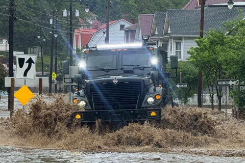
The D.C. area experienced a ton of rain this week — and now residents are seeing the aftereffects.
On a normal day, the Fredericksburg City Dock gets you on the water. Thursday, much of it is underwater with the Rappahannock River way over its banks.
Minister Victoria Wright with Arm of the Lord Ministries and her friend were at the dock Wednesday, sitting on a bench, which is now nowhere to be seen.
“I’ve been here every day this week, and I’m just amazed,” she said, describing the water as, usually, beautiful and blue.
“It was calm and peaceful, and you felt safe. But as I’m here today, this water you can see is kind of a brownish, dirty looking and it’s scary. The water is scary today.”
A few miles up Sophia Street, there’s a homeowner out of the flood plain, but the nearby bike path is out of commission.
He’s got an incredible view of what’s happening in the Rappahannock River, however.
“I think the river is obviously 14 or 15 feet above where it normally is, and there’s a lot of debris and trees and whatnot, flowing down the river right now,” he told WTOP’s Neal Augenstein.
He said there are flood areas that used to be impacted much more, there’s not terrible flood issues like there used to have.
- Listen to WTOP online and on the radio at 103.5 FM or 107.7 FM.
- Current traffic conditions
- Weather forecast
- Closings and Delays
- Sign up for WTOP email alerts
- Get custom alerts with the WTOP app for Apple and Android phones
Thursday’s weather was mild and humid, but drier than the rest of this week has been so far.
There continues to be a flood watch in effect for D.C. with rising waters from the Potomac River along the Georgetown waterfront and Wharf. A flood warning is also in effect until Friday evening for towns around the Potomac River including Leesburg and Potomac.
Maryland Gov. Wes Moore declared a state of emergency in response to the disastrous flooding in Western Maryland.
“Today, our thoughts are with the Marylanders who have been directly impacted by this storm, and our gratitude is with all of the first responders, crisis managers, and public servants who raised their hands to support our people in a moment of need,” Moore said in a statement.
Moore visited Allegany County, where the majority of flooding has taken place in the past few days, and elected to “accelerate” the state’s survey and rescue response to help as many people as possible.
Severe thunderstorms capable of producing damaging winds and large hail are possible on Friday afternoon, according to the National Weather Service. The day will also be hot and humid with highs in the 80s, only cooling after sunset into the upper 60s.
FORECAST
THURSDAY NIGHT:
Isolated Shower, Storms
Cloudy with Patchy Fog
Lows: 60s
Winds: Light
It will be mild and very humid again overnight with low temperatures falling into the 60s. Patchy fog may develop again and there’s also a chance for a few isolated showers and a few storms.
FRIDAY: STORM ALERT
Partly Sunny, Hot & Humid
Tracking Rain, Storm Chances
Highs: 84-89
Winds: Southwest 5-10 mph
Friday brings a somewhat complicated and iffy forecast for most of the DMV. Highs in many neighborhoods will reach the middle to upper 80s with heat index values at or above 90 degrees. Showers and storms are possible at any given point, however, forecast trends, or modeling, have differed in coverage and intensity. First Alert Weather is on “storm alert” for the potential for stronger storms, and will continue to carefully monitor the situation.
SATURDAY:
Showers and Storms Possible, Breezy
Highs: 83-88
Winds: Southwest 10-20 mph
Saturday should be the last for what has been a long string of unsettled weather days. Plan for showers and a few thunderstorms with highs well into the 80s.
SUNDAY:
Mostly Sunny, Less Humid
Highs: near 80
Winds: Northwest 5-10 mph
The Sunday forecast looks great with plenty of sun and highs near 80 degrees. Best of all, the stickiness factor won’t feel as noticeable.
CURRENT CONDITIONS
WTOP’s Neal Augenstein contributed to this report.
Get breaking news and daily headlines delivered to your email inbox by signing up here.
© 2025 WTOP. All Rights Reserved. This website is not intended for users located within the European Economic Area.