All the rain and wind that visited D.C., Maryland and Virginia this Fourth of July has gone away. In comes the long weekend that’s sounding a lot like a firework’s favorite song: ‘Pop it Like it’s Hot.’ Here’s what you need to know.
The National Weather Service says the D.C. area will see highs well into the 90s all weekend long, as a heat wave brings “oppressive heat and humidity” through the area.
The weather service has already issued heat advisories for most of the D.C. area through 8 p.m. on Friday, with excessive heat warnings stretching into portions of Southern Maryland and Virginia.
D.C. Mayor Muriel Bowser announced Friday that she activated the Extended Heat Emergency through Tuesday or until conditions improve.
The District is encouraging residents to check on neighbors and take precautions to avoid heat-related illnesses. Those without air conditioning in their homes are encouraged to seek relief.
Find a list of the cooling centers and extended hours on the District’s website.
Temperatures expected to reach just below the triple-digit mark on Friday, according to 7News First Alert Meteorologist Eileen Whelan.
“The rest of the holiday weekend is trending very hot and very humid,” Whelan said.
Don’t let the already high air temperatures fool you, though. It will definitely feel hotter outside.
Forecasters expect some nearby areas to feel closer to 109 degrees, prompting heat emergency declarations in D.C. and nearby jurisdictions. Portions of Southern Maryland may feel closer to 112 degrees, according to the 7News meteorologists.
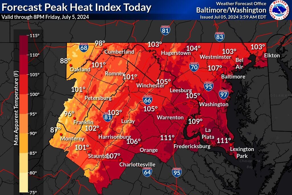
“Get ready for some of the highest heat index values that we have experienced all year,” Whelan said.
If the humidity wasn’t enough, forecasters also expect some storms and showers to move in during the early evening, bringing little relief from high feels-like temperatures.
- Listen to WTOP online and on the radio at 103.5 FM or 107.7 FM.
- Current traffic conditions
- Weather forecast
- Closings and Delays
- Sign up for WTOP alerts
By Saturday, forecasters expect slightly less humidity, some heat indexes in the triple digits and more scattered showers and thunderstorms after noon.
The heat remains the highest concern.
“Again, with such high humidity, our bodies can’t effectively cool,” Whelan said.
Thankfully, Whelan expects Sunday to be less humid, mostly dry and cooler as a cold front crosses the region.
Outages:
Current weather:
Forecast:
FRIDAY EVENING: HEAT ADVISORY UNTIL 8 P.M.
Isolated showers, storms
Temperatures: 90s to 80s
Heat Index: 105-109
Winds: Southwest 5-10 mph
Temperatures will slowly fall through the 90s and into the 80s this evening, with chances for scattered showers and storms. Some storms may bring brief gusty winds and pockets of moderate to heavy rain.
OVERNIGHT:
Mostly cloudy
Lows: 78-83
Winds: Southwest 5-10 mph
Plan for a very warm and very humid night ahead. Temperatures will likely not fall below 80 degrees in D.C., so little relief from the heat is expected. A few showers may pop on the radar, but won’t amount to much.
SATURDAY: HEAT ALERT
Partly sunny, scattered showers and storms
Highs: 92-96
Feels: 100-105
Winds: Southwest 5-10 mph
It will be another very hot and very humid day with feels like temperatures nearing 105 during the afternoon. Scattered showers and a few storms are likely during the afternoon and evening.
SATURDAY NIGHT:
Lingering showers and storms
Lows: 70s
Winds: South 5-10 mph
A cold front will drift to the south bringing added clouds and scattered showers and thunderstorms. Any wet weather chances that remain will diminish before sunrise.
SUNDAY:
Partly to mostly sunny
Highs: 92-96
Winds: North 5-10 mph
A slight drop in humidity is expected to round out the weekend, which will be a welcome change. It will still be hot with afternoon highs in the low to mid-90s.
NEXT WEEK:
The second week of July is trending hot and humid with highs in the 90s most days. It will feel even hotter with high humidity. Dew point temperatures will likely be in the low to mid-70s for much of next week. There are a few chances for rain, which we desperately need. The majority of the D.C. region is under a moderate drought with a severe drought in parts of northern Virginia, the Shenandoah Valley, and western Maryland.
Get breaking news and daily headlines delivered to your email inbox by signing up here.
© 2024 WTOP. All Rights Reserved. This website is not intended for users located within the European Economic Area.