Listen to WTOP online and on the radio at 103.5 FM or 107.7 FM for the latest weather conditions.
A week of April showers continued Thursday, but it wasn’t just rain that fell from the sky. Widespread showers and isolated thunderstorms produced graupel in parts of the D.C. area.
Here’s what you need to know.
A system moving into the D.C. area from the west began to form isolated thunderstorms Thursday around 2 p.m., according to the National Weather Service. Given the below average temperatures and other factors associated with this system, it was capable of producing graupel.
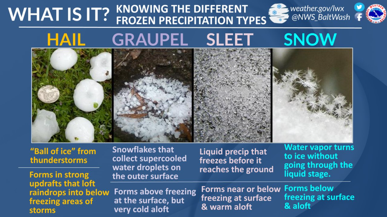
So what even is graupel?
“That’s a snowflake with supercooled water droplets around it,” 7News First Alert Meteorologist Steve Rudin said.
The graupel, which is essentially softer hail, even caused some accumulation in parts of Montgomery County, Maryland. WTOP got reports of graupel coming down in Ashburn, Virginia, as well.
Coastal flooding is also a concern, as the NWS issued a Costal Flood Warning for the shoreline of D.C. and Alexandria until 8 a.m. Friday. The unprotected area on the Southwest Waterfront at the D.C. Seafood Market is expected to flood, and water is expected to approach parts of the Hains Point Loop Trail, along with buildings near King and Union streets.
The NWS said to expect tides between 2 to 2.5 feet above normal, with the next high tide at Washington Channel occurring at 5:37 a.m. Friday.
Temperatures Thursday will drop into the upper 30s overnight. Friday will again see temperatures top out in the 50s, with more isolated showers expected before the forecast finally dries out Saturday, though it will be a windy weekend, Rudin said.
- Listen to WTOP online and on the radio at 103.5 FM or 107.7 FM.
- Current traffic conditions
- Weather forecast
- Closings and Delays
- Sign up for WTOP alerts
Full forecast
THURSDAY NIGHT:
Scattered clouds
Lows: 35-42
Winds: West 5-10 mph
Skies will clear this evening with clear and chilly conditions expected overnight.
FRIDAY:
Partly to mostly cloudy, breezy, isolated p.m. showers
Highs: 52-57
Winds: Northwest 10-15, Gusts to 25 mph
Another fast moving weather maker is set to bring a chance for showers and a windy afternoon. Gusts may exceed 30 mph at times.
SATURDAY:
Partly cloudy, windy
Highs: Around 55
Winds: Northwest 10-20, gusts to 30 mph
Plan for a windy and chilly Saturday across the DMV with gusts to 30 mph at times. A mix of sun and clouds during the afternoon will make for a fairly pleasant day overall.
SUNDAY:
Mostly sunny
Highs: Near 60
Winds: Northwest 10-20 mph
Typical average highs for the day will be the name of the game Sunday. Temperatures ranging from the upper 50s to lower 60s make for a beautiful afternoon, although it will be a bit breezy at times.
ECLIPSE MONDAY FORECAST:
The much anticipated solar eclipse on Monday, April 8th is trending dry in D.C. At this point, there will be a mix of sun and clouds, which should provide fairly good viewing conditions when the sun is eclipsed. The eclipse will be visible from 2:04 p.m. to 4:32 p.m., with the maximum eclipse occurring at 3:20 p.m. During this time, the moon will cover approximately 89% of the sun over the District.
Current weather
Get breaking news and daily headlines delivered to your email inbox by signing up here.
© 2024 WTOP. All Rights Reserved. This website is not intended for users located within the European Economic Area.