The Winter Weather Advisory for the D.C. region was canceled by mid-morning on Sunday, with only light flurries expected for the rest of the day.
Snowfall greeted people Sunday morning throughout most of the national capital area, but an unseasonably warm end to the work week kept the ground and pavement warm and accumulations low, according to Storm Team 4’s Mike Stinneford.
That’s why there wasn’t much to show for the morning’s preciptation by the time the Winter Weather Advisory was canceled around 10 a.m.
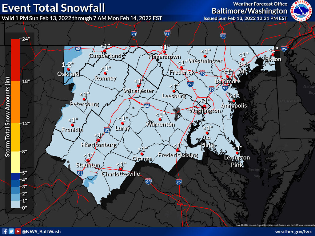
Accumulations barely reached an inch throughout the D.C. area. Some notable locations include:
Maryland
- Frederick — 1.4 inches
- BWI Marshall Airport — 0.7 inches
- Poolesville — 1.4 inches
- Silver Spring — 0.2 inches
Virginia
- Falls Church — 0.2 inches
- Leesburg — 1.4 inches
- Dulles International Airport — 0.9 inches
- Warrenton — 2 inches
Snow will mostly accumulate on non-paved surfaces, according to the National Weather Service.
Despite the snow not leaving much of a mark, the cold will remain, which could provide some challenges for drivers heading home after a later night than usual on Super Bowl Sunday.
“We will have a hard freeze tonight, and any standing water will freeze, and roads may become slick,” Stinneford said.
Stinneford said roads should be mainly just wet, with some slick spots on bridges and overpasses Sunday night. But roads could have some icy patches come Monday morning as temperatures plummet overnight.
Drivers should budget extra time and leave a generous amount of space between you and the car in front of you when heading out the door Monday morning.
- Listen to WTOP online and on the radio at 103.5 FM or 107.7 FM.
- Current traffic conditions
- Weather forecast
- Closings and Delays
- Sign up for WTOP alerts
Forecast:
TONIGHT: Partly to mostly cloudy and colder. Standing water on area roadways will freeze. Lows in the low to mid 20s.
MONDAY: Very cold with icy spots in the morning. Mostly sunny, brisk and chilly the rest of the day. Highs in the mid to upper 30s.
TUESDAY: Mostly sunny and seasonably chilly. Highs in the low to mid 40s.
WEDNESDAY: Increasing cloudiness and warmer. Highs in the low to mid 50s.