Another round of snow is on the way Thursday morning, and while it won’t be a blockbuster event as far as totals go, it’ll be enough — and just at the right time — to create a travel headache for commuters.
The National Weather Service issued a Winter Weather Advisory for the Baltimore-Washington metro area from late Wednesday night through midday Thursday.
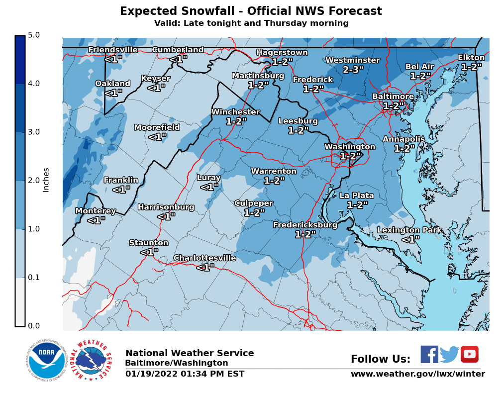
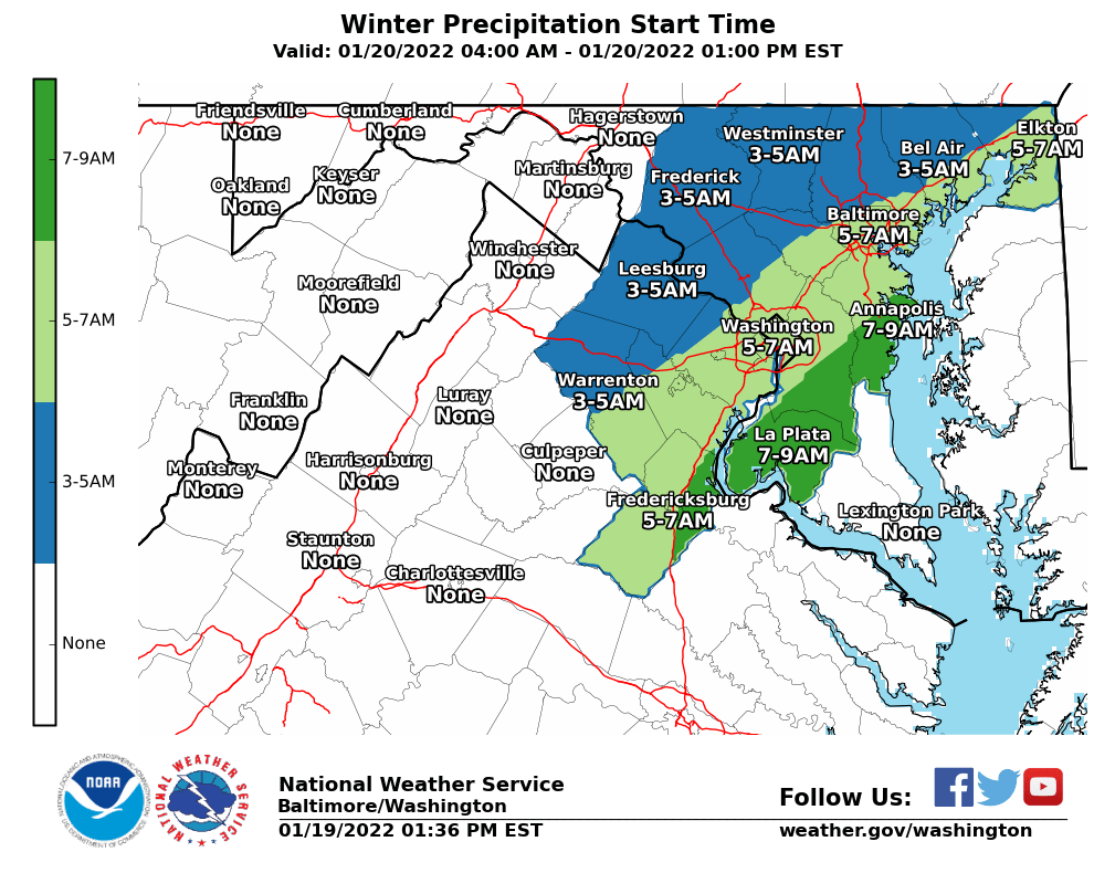
Rain will start late Wednesday night, changing over to snow, the weather service said. And while the expected snowfall will only top out around an inch or two, it’s expected to start in much of the area between 5 and 7 a.m.
A cold front will bring a blast of arctic air into the D.C. region after a relatively mild Wednesday. Those plummeting temperatures, as well as the rain, will make the transition to snow even more difficult for commuters.
“Since it will be raining overnight, road crews will not be able to pretreat the pavement,” Storm Team4 meteorologist Chuck Bell told WTOP. “This, combined with the fact that snow plows will also be stuck in slow-moving traffic, could lead to a very slow, slushy or slippery morning commute. If you have a work-from-home option on Thursday, take it.”
D.C. will deploy its snow team at 6 a.m. Thursday, to begin to salt the streets in preparation for a mix of rain turning into snow. Meanwhile, the Virginia Department of Transportation said Wednesday that crews have began pretreating interstates and primary and major secondary roadways ahead of the storm.
As always: Drive slow, leave plenty of stopping distance behind the vehicle in front of you, and take extra care on ice-prone driveways, bridges, overpasses and highway ramps.
- Listen to WTOP online and on the radio at 103.5 FM or 107.7 FM.
- Current traffic conditions
- Weather forecast
- Closings and Delays
- Sign up for WTOP alerts
A Winter Weather Advisory is now in effect for very late tonight through midday Thursday for the Baltimore-Washington metro area. Rain will move in late tonight and change to snow just before or during rush hour Thursday before ending near midday. pic.twitter.com/qa3PwG7Vjg
— NWS Baltimore-Washington (@NWS_BaltWash) January 19, 2022
As the snow tapers off, temperatures stay frigid: Highs from Thursday through Saturday won’t make it far above the freezing mark. Friday, in particular, is poised to be bitter cold — high temperatures are forecast in the mid-20s. A breeze will make it feel even colder, with wind chill values in the teens.
48° today will be the warmest of the next 10. Snow chances: Thurs 5-10am, generally 1″ to 2″. Roads go from wet to slushy between 7-9am. Delay travel until after 10am tomorrow, if possible. Sat. AM: odds are now favoring “less” rather than “more” snow but still worth watching. pic.twitter.com/G9lff7wcdX
— Chuck Bell (@ChuckBell4) January 19, 2022
The region’s next chance for significant snowfall comes late Friday into Saturday. Keeping in mind that the thinking could still change, recent trends in computer models aren’t looking great for winter weather lovers.
“The likelihood of getting more than 3 inches of snow with this storm are much lower today than they were yesterday, thanks to a more southern track,” Bell said. “It now appears more likely that any amounts of 6 inches or higher will be south of Richmond, toward Virginia Beach and Eastern North Carolina.”
Forecast:
Wednesday night: Rain developing, mainly after midnight. Lows in the mid- to upper 30s.
Thursday: Rain changing to snow, and ending in the afternoon. An accumulation of 1 to 2 inches possible. Becoming windy and colder. A morning high in the mid- to upper 30s, then falling temperatures.
Friday: Mostly cloudy and cold. A chance of light snow after sunset. Highs in the upper 20s.
Saturday: A chance of light snow early, then partly sunny. Highs in the lower 30s.


