Here we go again: Even after a sunny Wednesday, another round of winter weather is in the forecast for the D.C. region.
Here’s what you need to know:
- DC-area schools announce Thursday changes. Some school systems still have virtual learning, while others are calling it a full snow day. See all closings and delays here.
- Some COVID-19 vaccine clinics canceled. Fairfax County in Virginia and Montgomery County in Maryland have already announced cancellations for Thursday. Maryland’s clinics at Six Flags America and the Baltimore Convention Center will also be closed.
- Metrobus schedule changes for Thursday. The bus system will operate on a moderate snow plan; Metrorail won’t be affected.
- When is snow coming? Snow arrives around midnight Thursday, changing to sleet or freezing rain from D.C. to points east and south by early afternoon. Storm tapers off late Friday morning.
- Got photos? Tweet them at WTOP, if you can do it safely.
A low pressure system will move from the Texas-Louisiana region through the Carolinas, bringing a burst of wintry weather into the mix from late Wednesday night into Thursday afternoon. Expect a grab bag of snow, ice and freezing rain starting in the overnight hours of Thursday and lasting into Friday.
“All of us will see snow before sunrise,” said Storm Team4 meteorologist Mike Stinneford.
The snow will start in the southwest, and Thursday morning will see “several hours of heavy, wet snow” at a rate possibly reaching 1 to 2 inches an hour, Stinneford said. And ice is a strong possibility in the afternoon.
“Travel will be a problem; power outages will be a problem too,” Stinneford said. That mix of snow, sleet and freezing rain will continue Friday too, he added.
The National Weather Service has issued a Winter Storm Warning for the entire WTOP listening area, effective 3 a.m. Thursday through 6 a.m. Friday.
The weather service notes that ice accumulations could lead to power outages, tree damage and treacherous driving conditions for Thursday’s commutes, in addition to heavy snow.
“Snow Thursday morning will be heavy at times, with snowfall rates around 1 to 2 inches per hour possible along with visibility reduced to around one-quarter mile at time,” the weather service said, adding travel in heavier bands of snow “could be nearly impossible.”
- Listen to WTOP online and on the radio at 103.5 FM or 107.7 FM.
- Current traffic conditions
- Weather forecast
- Closings and Delays
- Sign up for WTOP alerts
Similar to the last few storms, the rain/snow line will move northward during the storm, bringing the potential for a significant accumulation of ice over parts of the area, Stinneford said. The precipitation will mostly stay snow over the northern and western suburbs, and change over to rain over southern Maryland.
Then, snow will mix with ice over the immediate metro area during the day Thursday, with mainly rain over southern Maryland.
Much of the area will see snow and ice Thursday night as temperatures cool below freezing, with the precipitation mixing with or changing to rain before ending Friday.
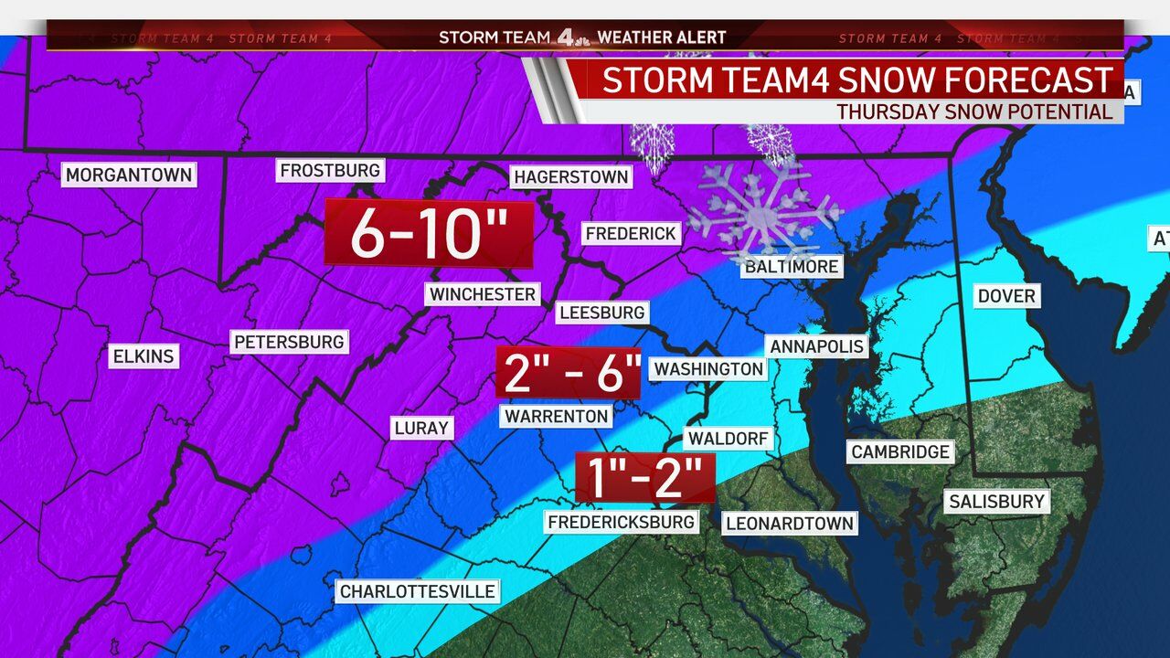
WTOP’s news partners at NBC Washington are calling for 6 inches or more north and west of D.C. — while the city itself over to the Eastern Shore, and south into Virginia along I-95, are eyeing 2 to 4 inches.
The weather service also forecasts significant ice accumulations of between a quarter and half an inch in a narrow area stretching from Annapolis to Fredericksburg.
“I’m very concerned about the icing potential that we will have for most of our region, with the exception of our northwestern suburbs,” Storm Team4 meteorologist Lauryn Ricketts said. “We could get a good deal of ice on top of the snow that could create some major problems, including travel concerns and power outages.”
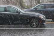
Commuters are being cautioned about likely hazardous driving conditions. If you can, stay home if you’re able to and watch the Mars landing.
Changes to transit, vaccination sites
With more snow and ice in the forecast, some areas have already started making changes to their Thursday plans in anticipation of tough road conditions.
Metrobus will be operating on a moderate snow plan Thursday. Metrorail should not be impacted. In Maryland, MARC’s Brunswick Line service will be suspended Thursday.
Fairfax County, Virginia, announced that it has canceled all COVID-19 vaccine clinics scheduled to take place Thursday at the Fairfax County Government Center and the four Health Department District sites. Anyone who had a Thursday appointment should receive an email notifying them of the cancellation that provides a link to reschedule for the upcoming week at the same site.
Arlington, Virginia’s, testing and vaccine sites will also be closed Thursday, as are vaccine clinics in Prince William County.
Montgomery County, Maryland, has also canceled its vaccine clinics for Thursday. The clinic scheduled for Richard Montgomery High School in Rockville will be moved to Saturday, Feb. 20 at the same location, and the Quince Orchard High School clinic will be moved to Sunday, Feb. 21.
Those who had Thursday appointments at either site have been automatically rescheduled and should have already received an email notifying them of the change, the county said.
Maryland’s Six Flags and Baltimore Convention Center sites will also be closed Thursday. All appointments for Six Flags America will be rescheduled for March 3.
For the latest road and traffic conditions, see WTOP’s traffic page or listen to updates every 10 minutes online or on the air at 103.5 FM. Submit traffic tips by calling 866-304-WTOP or tagging @WTOPtraffic on Twitter.
Northam: Parts of Va. still reeling from last ice storm
At a news conference Thursday, Virginia Gov. Ralph Northam said that there were residents in Hopewell that have been without access to running water since the last ice storm, and that efforts were still underway to fix that.
The governor also said there are still some in the commonwealth who do not have power, and crews are currently working to fix that, too.
Virginia State Police responded to hundreds of vehicle crashes during the last storm, and Northam cautioned Virginians to keep an eye on road conditions before deciding to venture out.
Forecast
Wednesday night: Snow developing after midnight; snow and sleet in southern Maryland. An accumulation of 1 to 3 inches by sunrise. Lows in the 20s to lower 30s.
Thursday: Wet snow, mixing with sleet and freezing rain. Precipitation will remain mainly snow north and west, and will become mainly rain over southern Maryland. Highs in the low to mid-30s.
Friday: Snow and sleet in the morning, becoming all rain by noon and ending by sunset. Highs in the 30s to lower 40s.
Saturday: Mostly sunny, blustery and cold. Highs in the upper 20s to lower 30s.
Current conditions
WTOP’s Abigail Constantino, Rick Massimo and Zeke Hartner contributed to this report.