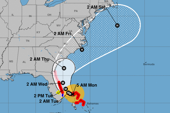
As Hurricane Dorian pounds the northern Bahamas, people up and down the East Coast — including in Virginia and Maryland — are closely watching where the hurricane will head.
“Everybody along the East Coast needs to be paying very close attention to this powerful hurricane,” said Dennis Feltgen, a National Hurricane Center meteorologist.

“Southeast Virginia is in the five-day track cone.”
As of Monday, the storm’s projected path had it clipping Maryland and Virginia coastal areas late Thursday into Friday. The immediate D.C. area is expected to see only showers with gusty winds on Dorian’s outskirts.
Places such as Virginia Beach and the Maryland and Delaware beaches, were being told to keep a close eye on the latest official forecast.
“Now is the time to make sure you have a disaster supply kit and an emergency plan,” the Maryland Emergency Management Agency tweeted.
Virginia’s Department of Emergency Management urged everyone in coastal areas to be prepared and familiarize themselves with local evacuation procedures as a precaution.
- Cutting it close: Florida’s fate may be a matter of miles
- Anxiety and impatience in long wait for Dorian in coastal US/a>
- How homeowners can begin to recover from hurricane damage
Forecasters said Dorian, a nearly stationary Category 4 storm as of Monday afternoon, would most likely to begin pulling away from the Bahamas early on Tuesday before curving to the northeast, running parallel to the U.S. Southeast seaboard. In the Bahamas, Dorian has wrecked homes and businesses.
At their most intense, Dorian’s wind speeds topped 185 mph, tying the record for the most powerful Atlantic hurricane to ever make landfall and 10 mph stronger than Hurricanes Irma, Rita, Maria, Katrina and Andrew.
The latest models show the storm could move through the Outer Banks of North Carolina, Storm Team4 meteorologist Lauryn Ricketts said.
Join me RIGHT NOW through noon on @nbcwashington – this could potentially move right through the #OuterBanks with the newest updates. It is dangerously close to the Florida coastline (including Daytona Beach) and Wilmington, NC…. pic.twitter.com/u49Px1npfr
— Lauryn Ricketts (@laurynricketts) September 2, 2019
The National Hurricane Center, late Monday morning, tweeted that the risk for heavy rains, “capable of producing life-threatening flash floods, is increasing over coastal sections of the Southeast and lower Mid-Atlantic regions” of the U.S.
The risk for heavy rains, capable of producing life-threatening flash floods, is increasing over coastal sections of the Southeast and lower Mid-Atlantic regions of the
United States into Friday from #Dorian. Full advisory: https://t.co/tW4KeFW0gB pic.twitter.com/nDSe9UwPln— National Hurricane Center (@NHC_Atlantic) September 2, 2019
Dorian is expected to weaken as it reaches the Mid-Atlantic, stirring up cooler waters and encountering a less favorable atmosphere, but it could still lead to coastal flooding and tropical storm conditions — sustained winds of at least 40 mph — far from the storm’s actual center.
Still, on Monday, uncertainty remained with Dorian’s exact track and the potent storm was expected to stay close to shore and hammer the East Coast with dangerous winds and heavy surf.
The National Hurricane Center warned even a slight deviation in track could drastically change impacts from Florida to the Carolinas. Though becoming less likely, a U.S. landfall could not be ruled out.
However, according to Feltgen, the storm’s projected path can easily shift because it will be trying to get around an area of high pressure as a low pressure system sets up over the eastern U.S. Such a complex setup has made Dorian’s future a particularly tricky one for computer models to predict.
“It’s basically an atmospheric tug of war that the storm is going to go in between,” said Feltgen.
“There’s a lot of moving parts in this.”
The Associated Press contributed to this report.


