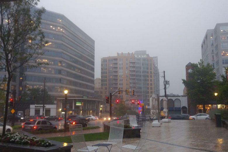
Storms with heavy rain and gusty winds that came through the D.C. area cooled down the temperatures enough to cancel the heat advisory before it was set to expire at 8 p.m. And although Thursday will be a little cooler, it will still be hot with highs in the lower 90 degrees but a feel-like temperature of near 100.
Scattered thunderstorms are possible in the afternoon on Thursday, but those won’t be as widespread as Wednesday’s storms, which prompted several severe weather advisories during the afternoon rush drive.
Wednesday’s heat index values were expected to reach 105 degrees, which prompted a heat advisory to take effect during the day. A heat advisory means that there’s a period of high temperatures, and that heat illnesses are possible.
Damages, delays, road closures
If a storm has already passed where you are, then the severe thunderstorm watch has been canceled for that area, Storm Team4 meteorologist Matt Ritter said Wednesday. Storms left the area before 8 p.m. but not before leaving damages to area neighborhoods.
In Maryland, MARC trains on the Brunswick Line are experiencing delays due to a tree blocking both tracks between Metropolitan Grove and Germantown stations. Find the latest service alerts here.
Update: Brunswick Line Delays — Brunswick Line Trains will be experiencing delays due to a tree blocking both tracks between Metropolitan Grove and Germantown Stations. Maintainers have been clearing other downed trees west… https://t.co/vfDNlXGeu7
— MTA Maryland (@mtamaryland) July 17, 2019
Montgomery County Fire and Rescue reported multiple trees and wires down. A National Weather Service spotter reported a tree down in Poolesville. A spotter in Charles County reported multiple trees down in the Nanjemoy area.
In Virginia, the WTOP Traffic Center reported that a tree had fallen and was blocking some lanes on Route 7 in Leesburg. A weather spotter reported a downed tree on the George Washington Memorial Parkway after Tulane Drive. There is also a report from a WTOP reader of a fallen tree on Route 29 in Fauquier County. WTOP’s Neal Augenstein is at the scene of a fire on Stinger Drive in Loudoun County that occurred after lightning was spotted in the area.
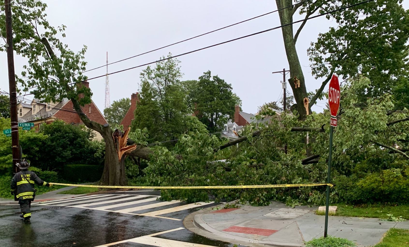
In D.C., a large tree on 43rd and Yuma streets fell down. D.C. Fire and EMS are telling people to avoid the area. They also reported calls about downed wires and urged people to treat downed wires as live and to stay clear of them.
- WTOP’s Weather Center
- Warm weather and heat-related illness: Why it’s important to stay hydrated
- Choosing a sunscreen that won’t harm you — or the environment
- Tips, advice and warning signs for coping with extreme heat
Forecast
The heat and humidity are not expected to break until early next week, said Storm Team 4 meteorologist Lauryn Ricketts. The humidity is expected to continue into Thursday, and Friday and Saturday are looking hazy, hot and also humid.
No thank you! Stay hydrated out there today. pic.twitter.com/l6bi1vLDuQ
— Amelia Draper (@amelia_draper) July 17, 2019
The heat index, which is what the temperature feels like, should hit 110 in D.C., on Saturday and 109 in Chicago and Detroit on Friday, Jeff Masters, meteorology director of Weather Underground, told The Associated Press. Wednesday marked Washington’s seventh straight day with temperatures of at least 90 degrees, and that streak was expected to last for another five days.
THURSDAY: Mostly cloudy. Hot and very humid. Scattered thunderstorms.
Highs: upper 80s to low 90s.
FRIDAY: Hazy, very hot and very humid. An isolated late-day thunderstorm.
Highs: upper 90s to near 100. Heat Index 100-105.
SATURDAY: Mostly sunny, humid and dangerously hot.
Highs: Mid 90s to around 100. Feels like 110.
Current conditions
Power Outages
The map below contains current power outages in Virginia, Maryland and D.C. This map is updated every 10 minutes.
How not to stress the power grid
The very hot days are sure to stress the region’s power grid, and if you find yourself without power, you can check for status updates using outage maps from Pepco and Dominion Energy.
Christina Harper, a spokesperson for Pepco, the utility that serves D.C. and its neighboring counties in Maryland (Prince George’s and Montgomery), said one thing residents can do in the coming days is set their thermostat at 78 degrees, “and forget it.”
While 78 may seem warm, Harper said it’s much cooler than the temperature outside, and it reduces the load on the power grid. “Let it stay there,” she said.
In addition, Harper suggested keeping shades drawn and making sure to turn off any nonessential appliances. If you must do any cooking or cleaning at home that requires the use of high-energy appliances, it’s best to wait until later in the day.
She added that when temperatures reach 95 degrees, or higher, the utility will “cancel or delay any scheduled nonemergency work so customers will be able to enjoy the comforts of their homes.”
Harper went on to say, however, that Pepco will continue any planned projects designed to improve system reliability that would require a planned outage.
“We would move ahead with any work that would help us to increase load, and during these really hot days, we expect our load will be impacted because more people are using their air conditioner units,” she said.
Harper reminded customers that it’s a good idea to download Pepco’s mobile app so that customers can easily get updates of planned outages and also receive news about when unplanned outages will be resolved.
Best chance for relief
If you’re looking for a good night to get outside and enjoy some summertime activities, the best chance you’ll have of the next few days will be Thursday.
“That’s mainly because it will be cloudy with some rain,” Ricketts said. “But it really doesn’t look like [the heat] breaks until early next week, with no relief until then.”
That being said, it’s important that those who don’t have a cool place to wait out the day’s hottest hours know where they can get some relief.
In the District, when the air temperature or the heat index passes 95, the heat emergency plan goes into effect. That means cooling centers for both residents and the homeless are open from noon to 6 p.m.
View an interactive map of the District’s cooling centers.
D.C. residents can get more information on heat advisories at the District’s website.
If you can’t make it to a cooling center and must be outside, some of D.C. Health’s tips for staying cool include:
- Drink plenty of water;
- Stay out of the sun;
- Avoid drinks with caffeine, alcohol and large amounts of sugar;
- Wear clothing that is loose-fitting, light-colored and breathable, such as cotton;
- Dress infants and children in cool, loose clothing, and shade their heads and faces with hats or an umbrella;
- Limit sun exposure during midday hours and in places of potential severe exposure, such as beaches;
- Wear sunscreen;
- Schedule outdoor activities carefully;
- Do not leave infants, children or pets in a parked car;
- Provide plenty of fresh water for your pets, and leave the water in a shady area;
- If you do not have access to a cool-temperature location, visit the District recreation center, library or senior center closest to you.
According to the city, those at the greatest risk for heat-related illness are: infants, children up to 4 years old, people 65 years old and older, people who are overweight and people who are ill or on certain medications.
The Associated Press contributed to this report.