As the widely reported dangerous heat starts building and heading to the D.C. area for the weekend — making the existing heat wave even worse — many may be wondering if the region could set some records.
It’s possible, and some of the records go way back.
There are two types of records in particular that could be tied or broken this weekend: the traditionally familiar record high — that is the “highest temperature on record for the date” — but also the less familiar record “high low” — that is the “warmest it’s ever been for a low temperature for the date.”
Below is a table of the record temperatures for Reagan National, Dulles International and BWI Marshall airports. Note that Washington’s highest high temperature records predate the airport. All of Baltimore’s records predate the airport.
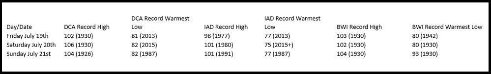
The warm low records are going to be the most in danger of being tied or broken. They’re on the table because not only is it going to be exceptionally hot during the daytime hours, but the exceptionally high humidity levels will keep the air from cooling down as much as it otherwise would. Water vapor holds onto heat much more efficiently than dry air does. (That’s why you can bake in the desert in the daytime but be too cold at night.)
As medical professionals point out, heat-related stress and therefore health problems are made worse at night, when it stays that warm because the body can’t rest or cool down.
A strong cold front will pass through the area Monday with showers and storms, possibly keeping us below 90 degrees for the day, breaking the heat wave then. But Tuesday will definitely be below 90 behind the front.
Next Wednesday looks much more seasonable for high temperatures and with more tolerable humidity levels.
The current heat wave (Washington-Reagan National data) started July 11.