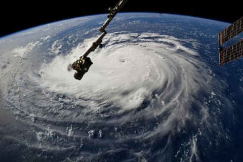
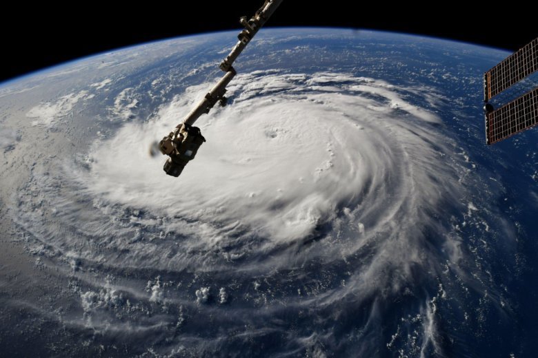
WASHINGTON — An “extremely dangerous” Hurricane Florence is picking up strength in its approach toward the East Coast, and its intensity will be close to Category 5 strength on Tuesday, according to the National Hurricane Center.
A life-threatening storm surge in Virginia and the Carolinas is likely, forecasters said. A “Storm Surge Watch” could be issued for some of the impacted areas by Tuesday morning, the center said in an 11 p.m. update. “Prolonged and exceptionally heavy rainfall” could cause life-threatening inland flooding in the mid-Atlantic in the days following Florence’s arrival Thursday.
As of 11 p.m. Monday, maximum sustained winds were near 140 mph with higher gusts. Swells are already affecting Bermuda and parts of the U.S. East Coast. The center said a “Hurricane Watch” will likely be issued Tuesday morning.
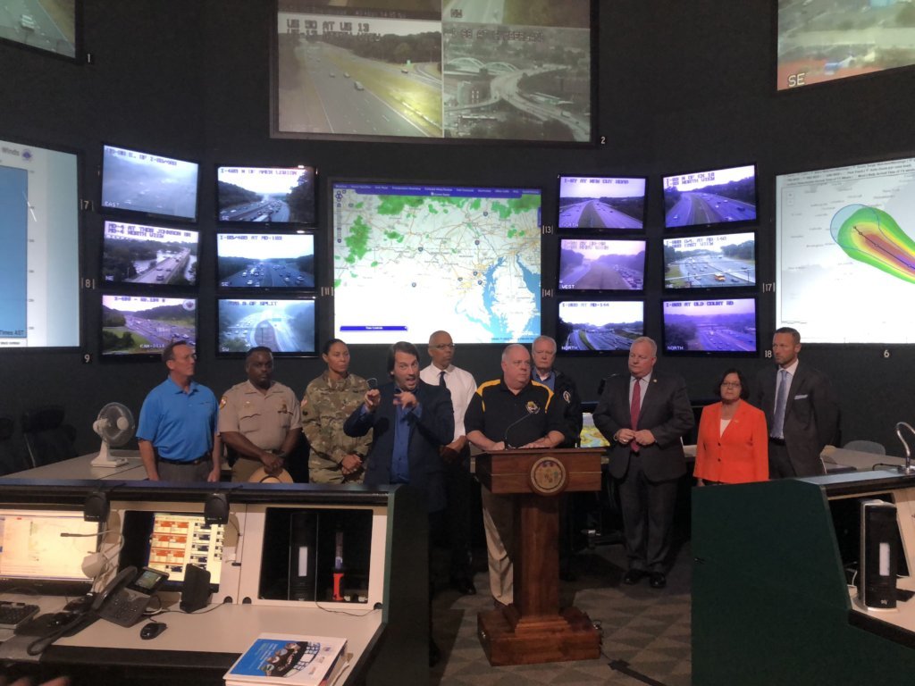
Maryland Gov. Larry Hogan declared a state of emergency Monday afternoon in anticipation of Hurricane Florence’s potential effects.

“We are preparing for the potential of historic, catastrophic and life-threatening flooding in Maryland,” Hogan said during a news conference.
Of particular concern, Hogan said, are low-lying and coastal areas, many of which are already water-logged from a very wet summer. Shelters are standing by to receive any displaced residents, and utility companies are prepared for severe outages.
“Things are fast-moving and constantly changing,” Hogan said.
In Virginia, which is already under a state of emergency, Gov. Ralph Northam ordered a mandatory evacuation for evacuation zone A — which includes the Eastern Shore and Hampton Roads areas — beginning at 8 a.m. Tuesday. Over 245,000 people live in this zone. (See an interactive map of Virginia’s evacuation zones here.)
“This is a serious storm, and it’s going to effect the entire state of Virginia,” Northam said.
Still over the Atlantic, Florence is poised to strike the East Coast on Thursday. Strong winds, storm surge and life-threatening flooding are in store into early next week.
Mandatory evacuations have been ordered for the Outer Banks. A mandatory evacuation started at noon for Hatteras and Ocracoke islands in North Carolina. Other parts of the Outer Banks are ordered to evacuate starting at 7 a.m. Tuesday.
Monday afternoon, South Carolina’s governor ordered an evacuation of the state’s entire coastline starting at noon Tuesday.
Here’s the latest on Florence, what the D.C. area can expect, and how officials are responding to the storm.
Latest on Florence
For the latest official information on Florence, consult the National Weather Service, the National Hurricane Center, and your local authorities.
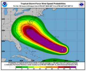
The National Hurricane Center said Florence was growing in both size and strength. In an 11 p.m. update, the center said that “there remains high confidence that Florence will be a large and extremely dangerous hurricane, regardless of its exact intensity.”
The projected path is honing in on a Carolinas landfall around Thursday — though forecasters cautioned it’s still too far out to know for certain exactly where Florence could come ashore. The outlook calls for Florence to be an extremely powerful, high-end Category 4 storm.
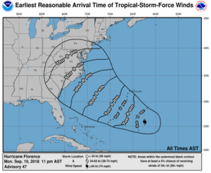
The center said damaging hurricane-force winds are likely along portions of the Carolina shoreline. It also warned of damaging winds spreading inland through the Carolinas into Virginia.
What’s in store for the DC area
The D.C. area could see at least tropical-storm-force winds of about 40 mph from Florence. If that does pan out, those winds would most likely arrive late Thursday night.
D.C. is unlikely to experience hurricane-force winds, because the storm will lose its punch after it makes landfall hundreds of miles to the south. For the Virginia, Maryland and D.C. region, it’s widespread flooding that’s fast becoming a concern.
Although it’s still too far out to know for certain what the impacts on the area will be, computer models are flirting with the idea that Florence could slow down drastically over land.
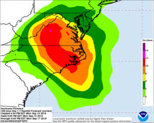
That has the potential to bring persistent tropical downpours to much of Virginia up into D.C. from Friday into early next week. The ground is already saturated from days of rain by a separate weather system.
The National Oceanic and Atmospheric Administration’s Monday GFS model highlighted the potential for up to a foot of rainfall in southeast Virginia and southern Maryland.
That said, the latest run of the European model brings Florence ashore farther south, and moves it more inland — a path that would bring less rain to D.C.
A European-model path, however, would take a big toll on the Shenandoah Valley, and ultimately impact the D.C. area as a bloated Shenandoah River flows into the Potomac.
During a Facebook Live Monday afternoon, Storm Team 4 meteorologist Doug Kammerer explained that such a heavy volume of water — combined with eastern winds hampering their flow into the Chesapeake, could cause “major problems.”
“This is about as serious of a storm as we get,” Kammerer said.
The biggest threats for the area are coastal and inland flooding. Areas near Maryland’s Monocacy, Potomac and Susquehanna rivers are vulnerable to flooding, and both downtown Annapolis and Baltimore’s Fells Point neighborhood are prone to coastal floods. All these areas, officials urged, should be keep an eye on the forecast.
A hurricane’s impacts can be far-reaching, no matter where the storm actually hits. Jeff Caldwell, a spokesman for Virginia’s emergency management office, cautioned of the potential for “massive flooding” throughout the state.
He added that Virginia’s deadliest tropical cyclone on record, 1969’s Camille, killed 150 people through flooding alone — even though the storm made landfall in Mississippi.
In Maryland, officials were especially concerned about rivers spilling over their banks, on top of flooding in low-lying urban areas along Chesapeake Bay.
“Our ground’s already saturated,” said Edward McDonough, a spokesman with the Maryland Emergency Management Agency. “It could create heavy amounts of rain anywhere from western Maryland to the Eastern Shore, the worst areas are going to depend on the final track of the storm.”
- WTOP Weather Center
- WTOP Traffic Center
- Current Weather Radar
- Severe Weather Map
- Listen Live to WTOP
- Get WTOP Alerts
Virginia Gov. Ralph Northam joined North and South Carolina in declaring a state of emergency on Saturday, allowing officials to start mobilizing a storm response.
In a statement Monday, D.C. Mayor Muriel Bowser said District officials are monitoring potential impacts.
“We remain committed to keeping our residents safe, prepared, and informed,” she said. “I encourage all District residents and visitors to take this storm seriously and stay up to date on the latest emergency information, including signing up for our AlertDC messaging service.”
D.C. officials also asked residents to be “proactive” in stocking up on supplies and reviewing emergency plans:
We’re monitoring Florence and have two asks of you:
-Encourage family/friends in path to listen to officials and have a plan on communicating w/ you once storm passes.
-Be proactive. Now is the time to replenish your supplies, sign up for alerts and review your emergency plan. https://t.co/wliyCyCgG7— DC Homeland Security (@DC_HSEMA) September 10, 2018
What you can do to prepare
While Florence’s impact to the D.C. area is still uncertain as of Monday, it’s best to prepare for the worst. Ready.gov has an exhaustive list of resources to help you prepare.
Before there’s a rush on stores, restock your emergency-preparedness kit. Ideally, that includes …
- Water and non-perishable food sufficient for at least three days
- Medications
- Flashlight
- Batteries
- Cash
- First aid supplies
And don’t forget to make sure your four-legged family members are ready, too.
The threat of flooding, of course, means more evacuations will be likely. Area residents can view up-to-date information on evacuation zones in Maryland and Virginia online.
“Start now to prepare your families and your homes for potential heavy rains, wind and possible flooding,” Hogan said Monday afternoon.
Howard County, Maryland’s emergency management director for flood-stricken, Ryan Miller, said planning ahead can make all the difference as conditions deteriorate.
“It might be making plans to stay with someone else, it might be removing valuable items from the basement,” Miller said. “Maybe testing the sump pump would be a good idea.”
Forecast:
Monday night: Isolated showers, some fog; temperatures in the 60s and 70s.
Tuesday: Mostly cloudy, highs in 80s; 40 percent chance of afternoon/evening showers.
Wednesday: Mostly cloudy, highs in low to mid-80s, isolated chance of showers.
Thursday: Isolated showers and thunderstorms possible, highs in mid-80s.
Friday: Chance rain and wind, TRACKING FLORENCE, low 80s.
Saturday: Chance rain and wind, TRACKING FLORENCE, low 80s.
Sunday: Chance rain and wind, TRACKING FLORENCE, low 80s
Current conditions:
WTOP’s Kate Ryan contributed to this report.