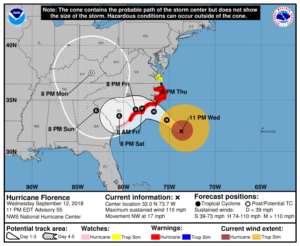
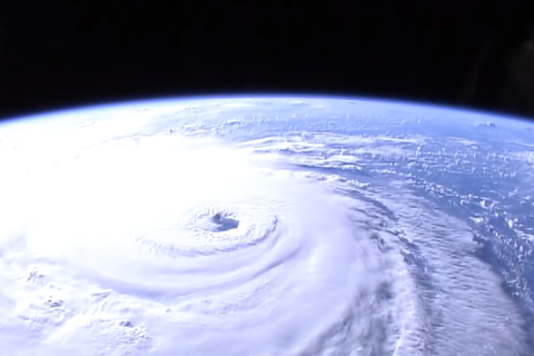
WASHINGTON — Hurricane Florence is now a Category 2 storm, with maximum sustained winds at around 110 mph, the National Hurricane Center said in an update at 11 p.m. Wednesday.

Though the hurricane has weakened somewhat, the center continues to warn of serious storm surge and rainfall threats for much of the southeast and parts of the mid-Atlantic regions.
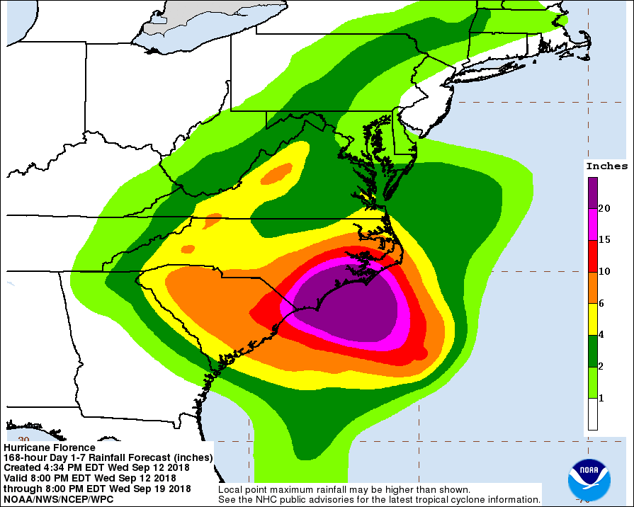
The storm could dump 20–30 inches of rain along the Carolina coast and up to a foot inland, but the D.C. area itself may only see remnants of the hurricane next week.
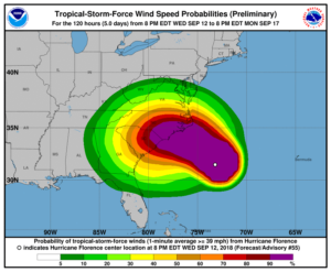
Earlier, Florence was already downgraded to Category 3 with winds of 120 mph. Its hurricane-force winds extend outward up to 70 miles, and its tropical-storm-force winds extend outward up to 195 miles.
“While Florence has weakened below major hurricane intensity, the wind field of the hurricane continues to grow in size. This evolution will produce storm surges similar to that of a more intense, but smaller, hurricane, and thus the storm surge values seen in the previous advisory are still valid,” the center said Wednesday night.
“The threat of rainfall has also not diminished, and these impacts will cover a large area regardless of exactly where the center of Florence moves.”
In terms of speed, it is expected to slow down considerably by late Thursday and Friday and move through early Saturday, according to the center.
Though the hurricane’s path is heading toward the Carolinas, the storm’s effects may change as it further evolves.
- WTOP Weather Center
- WTOP Traffic Center
- Current Weather Radar
- Severe Weather Map
- Listen Live to WTOP
- Get WTOP Alerts
Where is Florence and when will it fall?
For the most recent official information on Florence, consult the National Weather Service, the National Hurricane Center and your local authorities.
The latest update from the National Hurricane Center. #Florence has weakened some but extremely dangerous storm surge and catastrophic multiple feet of rainfall is still anticipated for eastern North Carolina. #ncwx pic.twitter.com/T7azP9vHvN
— NWS Newport/Morehead (@NWSMoreheadCity) September 13, 2018
At 11 p.m. Wednesday, Florence was 280 miles southeast of Wilmington, North Carolina, moving northwest at 17 mph.
That motion, as well as a decrease in speed, is expected through Saturday. Its center will approach the hurricane warning area on Thursday and Friday, then move slowly near the coastline Saturday.
The projected track had Florence hovering off the southern North Carolina coast from Thursday night until landfall Saturday morning or so, about a day later than previously expected. The track also shifted somewhat south and west, throwing Georgia into peril as Florence moves inland.
Florence’s expected slowdown means a prolonged period near the coast, said Joel Cline with the National Hurricane Center. It could then head west and southwest.
The result: prolonged storm surge, wind and rain.
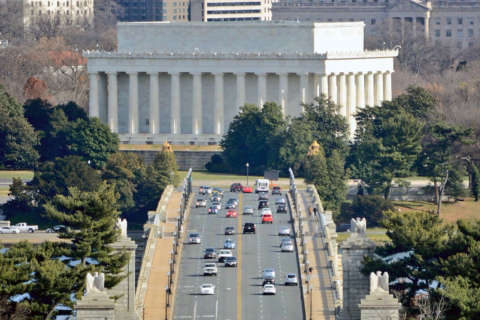
The impact on DC, Maryland and Virginia
The D.C. area will feel considerably less of an impact from Florence, according to current projections. Rainfall forecasts through Wednesday are around 1–2 inches. The worst of Florence’s winds will probably stick well to the region’s south.
The region probably won’t get rain until Tuesday, Wednesday or Thursday, Storm Team 4 meteorologist Chuck Bell said. Keep in mind, however, that the forecast is still subject to change.
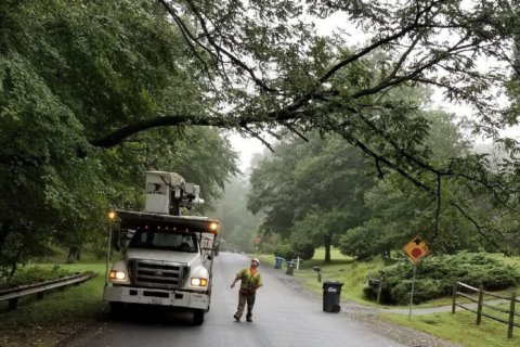
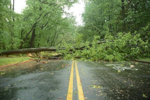
Additional rainfall still raises serious concern around the D.C. area, which is already water-logged.
D.C., Maryland and Virginia are each under states of emergency. And, Cline doesn’t believe Florence will leave the region unscathed.
“It could get caught up in a funnel system and bring rain later in the week,” he said.
Northam: ‘This storm will effect you’
The southern portion of the Virginia coast — from the North Carolina border to Cape Charles Light — is under a tropical storm watch. Some portions of Virginia could get around 6 inches of rainfall.
During a news conference Wednesday, Virginia Gov. Ralph Northam announced that 59 local shelters were open across Virginia, and that two commonwealth-managed facilities would be opened — one at Christopher Newport University in Newport News and the other at the College of William & Mary in Williamsburg.
“Even if you’re not on the coast, this storm will effect you,” said Northam, who also urged residents to get prepared if they’re not already.
Virginia Sen. Mark Warner urged FEMA Administrator Brock Long to expedite disaster-relief efforts to the commonwealth, which is under a state of emergency.
“Hurricane Florence is expected to cause serious flash flooding, mudslides, and river flooding in parts of Virginia that do not have a history of flooding and have already received large amounts of rainfall this year,” Warner wrote. “These areas may not have the resources available to immediately respond to large scale flooding.”
These severe conditions, of course, will impact air travel, too.
Forecast
Thursday: Few scattered showers, mostly cloudy, warm and humid; highs in upper 70s to mid-80s
Friday: Scattered showers, mostly cloudy, warm and humid; highs in the upper 70s to mid-80s
Saturday: Chance of showers, mostly cloudy, warm and humid; highs around 80
Sunday: Chance of showers, mostly cloudy, warm and humid; highs around 80
Be prepared
- Have at least three days of food, water and medicines on hand
- Charge phones
- More preparation tips and a checklist
- Sign up for alerts and apps
- Maryland Prepares mobile app, with real-time local information, is available for both Android and iOS phones.
- Virginia residents can sign up for state-issued emergency email alerts.
- D.C. residents can sign up for city alerts.
Scattered showers and isolated thunderstorms have developed. Locally heavy rain is occurring, turn around don’t drown if you encounter high water on roads. pic.twitter.com/UsdyERg3Nr
— NWS DC/Baltimore (@NWS_BaltWash) September 12, 2018
In the Carolinas
As of Tuesday, about 1.7 million people in North and South Carolina and Virginia were under warnings to evacuate the coast, and hurricane watches and warnings extended across an area with about 5.4 million residents.
The heavy rainfall projected for parts of North Carolina would produce a catastrophic flash flooding and significant river flooding, according to the National Hurricane Center. Isolated areas could get 40 inches. The volume of rain could cause an environmental disaster, too, if the water inundates the region’s many industrial waste sites and hog manure ponds.
The impact is expected to be similar to that of Hurricane Harvey on the Houston area last year, said Dennis Feltgen of the National Hurricane Center.
WTOP’s Steve Dresner reported from Morehead City, North Carolina, that while some people have already left the area as a precaution, most are electing to stay in the area and watch their properties.
On the Outer Banks, an area where North Carolina Gov. Roy Cooper urged residents to evacuate, residents have experienced traffic jams and bottlenecks, said ABC News correspondent Jim Ryan.
“Damaging hurricane-force winds are likely along portions of the coasts of South Carolina and North Carolina,” the National Hurricane Center said. “Damaging winds could also spread well inland into portions of the Carolinas and Virginia.”
Current conditions
WTOP’s Teta Alim, Rick Massimo and Kate Ryan contributed to this report. The Associated Press also contributed to this report.