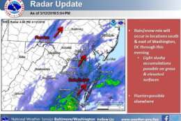
5 PM update: We're seeing a rain/snow mix across southern Maryland which will continue into the evening. Some slushy snow accumulation is possible, mainly on grass and elevated surfaces. pic.twitter.com/Qy95rcMAjB
— NWS DC/Baltimore (@NWS_BaltWash) March 12, 2018
Now that our average high is 55° these 40-something-degree days are starting to look and feel a bit out of place. Overnight lows near freezing all week will likely slow down the #CherryBlossoms. I still think around the 25th of March for peak blooming. pic.twitter.com/Hu6fshkdGK
— Chuck Bell (@ChuckBell4) March 12, 2018


WASHINGTON — As New England braces for another wicked Nor’easter, the D.C. region “enjoyed” a chilly, overcast Monday, dodging most of the wintry system so far.
That could change somewhat. Scattered rain and snow showers are possible this evening, especially in areas south of D.C. and east of Interstate 95, said Storm Team4’s Amelia Draper.
But even in these areas, she said, there will be no accumulation.
“This event is really a low-impact event for the region, with temperatures just too warm for any snow to stick,” she said.
The threat of any wintry precipitation will pass around midnight, Draper added, but expect a blustery Tuesday, with wind chills in the 20s and 30s.
This is the third in a series of big winter storms, and forecasts call for high winds and blizzards in eastern Massachusetts Tuesday. It comes on the anniversary of the start of the three-day blizzard of 1993, which crippled much of the East Coast and came to be known as the “The Storm of the Century.”
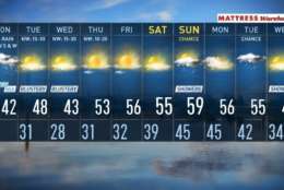
Forecast
- Monday: Cloudy with rain and wet snow. No accumulations expected; highs in the mid-30s to low 40s.
- Tuesday: Partly sunny but blustery and cold; highs in the low to mid-40s.
- Wednesday: Partly sunny but still blustery and cold, highs in the low 40s.
Current conditions
Traffic
Storm Team4’s Somara Theodore said the system’s impact on the commute will mainly be a nuisance. See a map of the most-current traffic conditions below.
Get the latest traffic updates on the WTOP traffic page, by following @WTOPTraffic on Twitter and by listening to 103.5 FM on-air or online.
WTOP’s Nahal Amouzadeh contributed to this report.