WASHINGTON — The lucky thing about living in the Mid-Atlantic is the luxury of having four unique seasons.
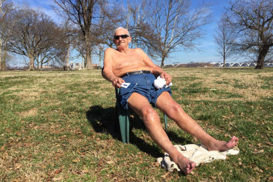
But I think it’s safe to say that the winter season has been completely absent this year (although it seemed to start off on the right foot). I have been getting questions repeatedly about this winter (or lack thereof) — and understandably so, considering that the area is on track to top out at one of the warmest winters on the record books.
So what is going on? Is there any chance of seeing snow over the next few weeks?
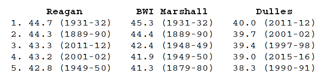
First, let me tackle some records so I can show you just how warm this winter actually is.
So far, the average temperature in D.C. for the month of February has been 45.5 degrees. With temperatures above average as the month ends, we are on track to be at least the second warmest, and likely warmest, February on record for the region. And it isn’t just February — overall, we are in at least the 3rd or 4th warmest winter for the area.
For context, here is some historical temperature data for Reagan National, BWI Marshall and Dulles International airports from the National Weather Service.
Warmest Februaries
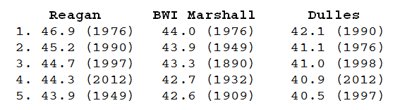 February 2017 (through the 21st)

Warmest Meteorological Winters (Dec. 1 through Feb. 28-29)
Winter 2016-2017 (through Feb. 21)
![]()
(NOTE: Temperature records for D.C. have been kept at Ronald Reagan National Airport since 1941. However, temperatures were measured at other locations prior to Reagan, and records for D.C. date back to 1872. Temperature records for Baltimore have been kept at BWI Marshall Airport since 1950. Additional temperature records for the Baltimore area date back to 1872. Temperature records in the Dulles, Virginia area have been kept at Dulles International Airport since 1962.)
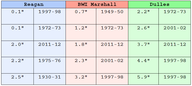
While the area has had some snow (it might be a distant memory), it doesn’t look like much more is in sight. D.C. has only recorded 1.4 inches of snowfall this season, while BWI Marshall has seen 0.7 inches, and Dulles has received the highest total snowfall, 1.6 inches.
Here are the lowest seasonal snowfall totals for the area’s major airports, including the most recent that was not too long ago – the winter of 2011-2012.
Of course, this winter is on track to make it onto this list. (Data courtesy of the National Weather Service in Sterling, Virginia.)
Lowest seasonal (July 1 – June 30) snowfall
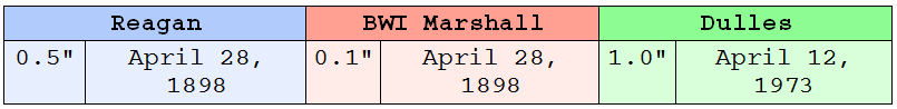
For all those grasping at straws for at least one day of snow, rest assured that the area has had some snow as late as March (the blizzard of 1993, the St. Patrick’s Day snow of 2015, etc.). The area has even had some snow in April (albeit a long, long time ago).
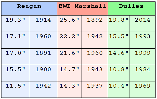
Top 5 snowiest Marches
Latest measurable snowfall
And while I know the snow lovers are clinging to hope for at least one snow day, it just doesn’t look like it is in the cards.
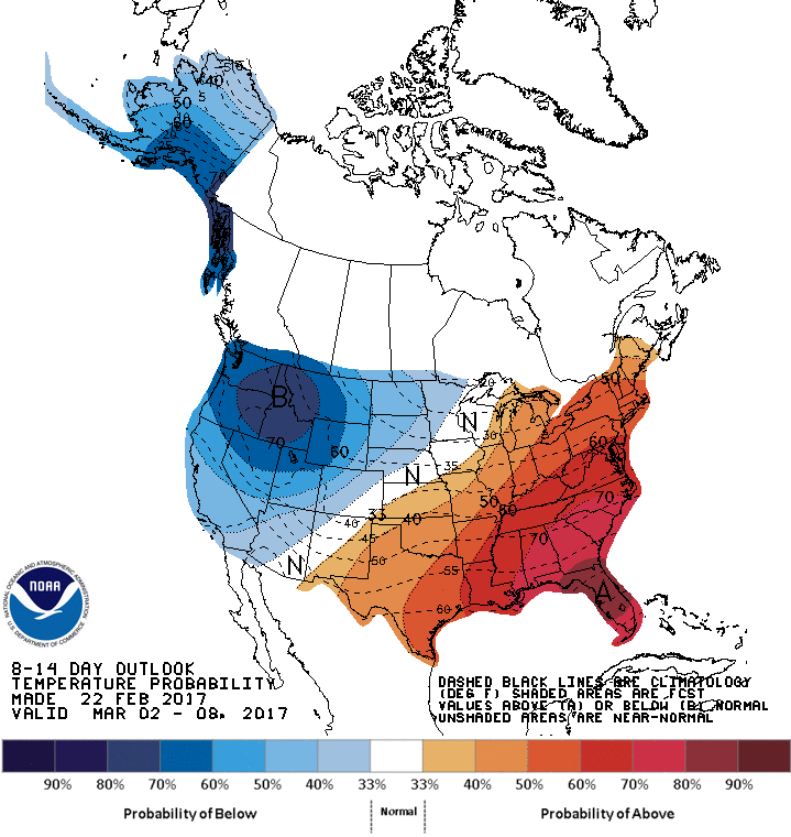
The Climate Prediction Center has a greater-than-60-percent chance that the area will continue with above-average temperatures through at least the beginning of March.
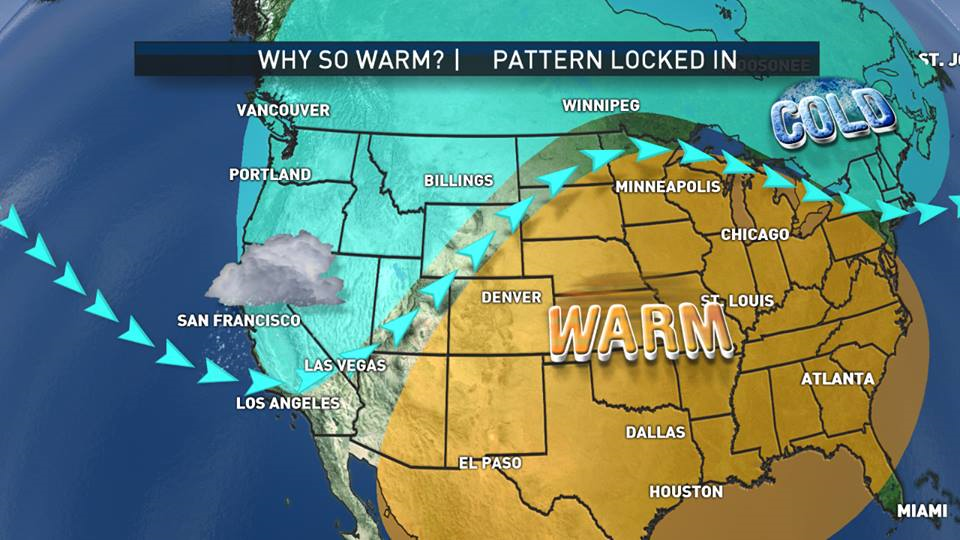
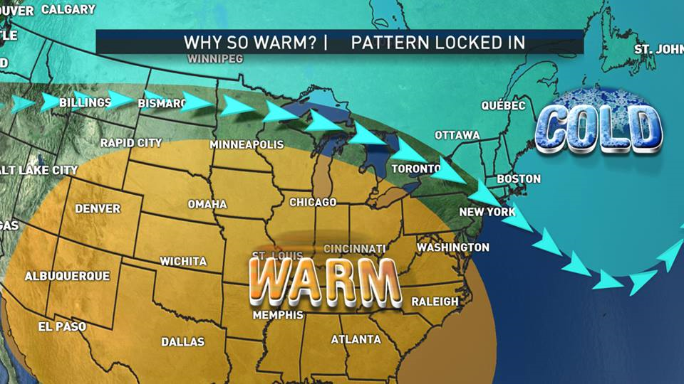
So what exactly is going on with this year’s mild winter?
There is no blocking mechanism in the atmosphere over the upper Atlantic to help keep cold air in place over the East Coast. The jet stream also is playing a huge part in the extended warmth.
“Abnormally warm water temperatures found in the waters near Alaska and the Canadian Pacific Coast have persisted in the area for three years,” said StormTeam4 Chief Meteorologist Doug Kammerer.
“With this warmth, the jet stream would flow above the warm blob, into Canada and across the heartland of the U.S., bringing cold weather to the eastern half of the United States,” he said.
“This year, the warmth in the Pacific Ocean dissipated, changing the flow of the jet stream. It travels across Northern California, skimming along the border between the U.S. and Canada before exiting into the Atlantic Ocean around New England.”
So unfortunately (or fortunately), it looks as if this pattern is here to stay — along with the pollen. Tree pollen will continue to be on the high side until the region gets some rain. There are moderate drought conditions through a good portion of the area, so some precipitation — any precipitation — is needed.
The good news is that cherry blossoms could peek slightly sooner! The earliest cherry blossom peak date was March 15 back in 1990 (which was also a very mild winter — see above).
Keep an eye on those blooms and flowers. Actual spring may come a lot quicker than anybody ever thought.