WASHINGTON — So let me get this straight: We were in the mid-60s for the weekend and now this week we will barely get out of the 30s on some days?
And we can expect more snow? Sounds like a typical winter in the D.C. area.
In fact, Monday Feb. 24 will most likely be the warmest day in terms of air temperature the area experiences this work week as several reinforcing shots of cold air move through the region.
Hopefully everyone enjoyed the warming temperatures and the snow pack finally melting off because winter is not quite done with the D.C. area.
␎ 
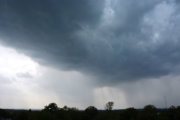
A satellite view of the melting snow over the region since Feb. 16 because of warming temperatures.
Clouds will fill in by Tuesday ahead of the next disturbance which brings a few flurries and sprinkles to the region.
Temperatures on Tuesday will be mainly in the 30s, with a few spots moving into the low 40s.
By early morning Wednesday, another piece of energy diving into the Mid-Atlantic from the Midwest will bring some light snow showers to the region. Light snow will fall through the morning commute through the early afternoon hours before clearing in the late afternoon.
Again, we’re not expecting much in accumulation with this system, just minor amounts.
␎ 
By Wednesday evening, snow accumulations amount to just around a dusting, based on an in-house computer model.
Of course we’ll continue to watch this as we head into Tuesday but for the most part we’ll expect a dusting to less than 1 inch of snow around our area. The heaviest amounts (less than 2 inches) will, as usual, line-up against the Appalachian Mountains and we could have some pockets of higher totals (around 1 inch) east of Interstate 95, but this will be more of a “conversational” snow.
By Thursday, temperatures return to around 40 degrees with sunshine as high pressure builds into the region. But then another reinforcing shot of cold air will drop our temperatures back into the 30s on Friday for daytime highs with partly cloudy skies.
A few flakes could fly around on Saturday as well but, again, not expecting a big event by any means.
Follow “>WTOP Facebook page.