

What will you do this week that you didn’t do during the heat wave? Post a comment in this story, comment on WTOP’s Facebook Page or use #WTOPTalkback or #WTOP on Twitter.
Dave Dildine, wtop.com
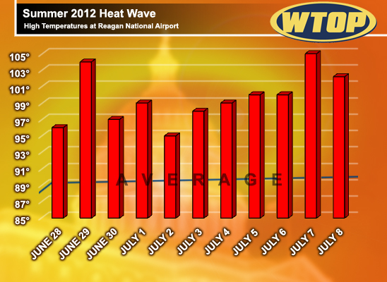
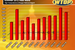
WASHINGTON – Washington’s streak of excessively hot weather ended this weekend after 11 consecutive days of temperatures exceeding 95 degrees at Ronald Reagan Washington National Airport. On Sunday, the mercury rose to 102 degrees, the 21st time this year the temperature has surpassed the 90-degree mark.
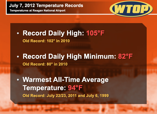
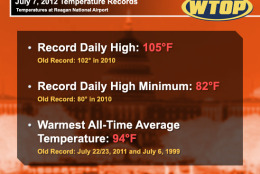
The heat wave peaked Saturday, when the temperature reached 105 degrees, a new record for the date. It also was one of the hottest temperatures ever recorded in Washington, the fifth time in 2012 the temperate reached or surpassed 100 degrees. The average daily high temperature from June 28 to July 8 was 99.5 degrees.
Recent Heat Waves
How does this year’s summer heat wave stack up against years past?
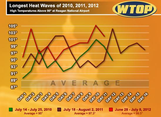
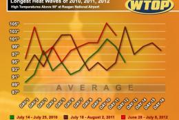
In 2011, a mid-summer heat wave brought high temperatures of 90 degrees or higher for 15 consecutive days between July 18 and Aug. 2. Twelve of those days were hotter than 95 degrees and temperatures soared above 100 degrees on four days in that stretch.
The 2011 heat wave climaxed on Friday, July 29 when the mercury soared to 104 degrees, a new record for the date.
In 2010, a 12-day-long heat wave cooked Washington with 90- and 100-degree temperatures between July 14 and July 25. A high of 101 degrees on Saturday, July 24 punctuated the hot streak. The average high temperature during that period was 95 degrees.
This Summer in Perspective
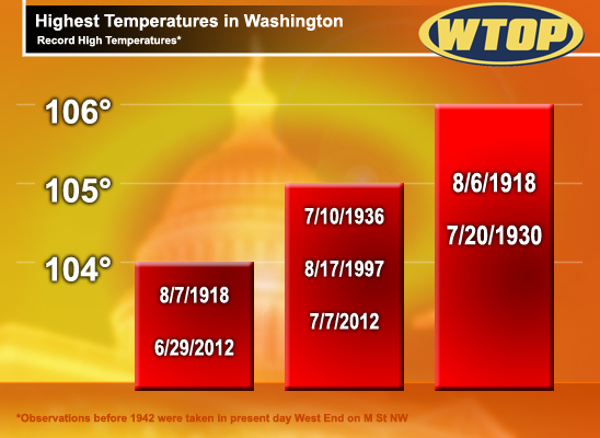
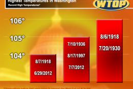
The intense heat in late June and early July was downright dangerous. Saturday’s high of 105 degrees was 1 degree shy of the city’s all-time record. It is one of only five times the thermometer has topped 105 degrees or higher.
Despite the recent record-breaking heat, June 2012 was actually “cooler” – relative to previous years. The average high temperature for June at Reagan National Airport was 85.9 degrees, compared with 87.9 and 89.8 degrees in 2011 and 2010 respectively.
Like much of the country, all three summers in Washington have featured daily temps, both high and low, that are well above seasonal norms. June 2012 was the eighth month in a row that Washington experienced an above normal monthly average temperature. Two daily high temperature records were set in June.
This year’s high temperature trend began before the “official” start of summer. This past May was the fourth warmest May on record in Washington.
The daily high temperature was at least 70 degrees each day in May, the warmest May on record. The month featured high highs and high lows. The lowest temperature recorded during the month was 52 degrees. On May 25, the overnight low at Reagan National managed to drop to a mere 71 degrees, a record high minimum temperature for the date.
Even earlier this year, Washington saw the warmest March on record.
Looking Ahead…
ABC7 Meteorologist Steve Prinzivalli says the region is entering the hottest time of the year.
“Our average high temperature in Washington is 89 degrees, the highest of the year, between July 7 and July 22.”
Seasonal conditions following the passage of a cold front will bring relief to the sun-baked region this week. Temperatures are expected to be near or slightly below average for the next several days.
Howard Silverman, senior forecaster at the National Weather Service in Sterling, Va., says that the recent warm spell does not necessarily mean the rest of the summer will be hotter than average.
“We’ve just been in a warm pattern for the past several weeks. With the cold front that [moved through] the area on Sunday, we’ll have cooler conditions for the rest of this week,” Silverman says.
Silverman also notes that the recent hot spell is not necessarily a precursor of hot weather to come.
Follow WTOP on Twitter.
(Copyright 2012 by WTOP. All Rights Reserved.)