A look at Hurricane Carla and some of the most damaging hurricanes to hit the United States since 2000.
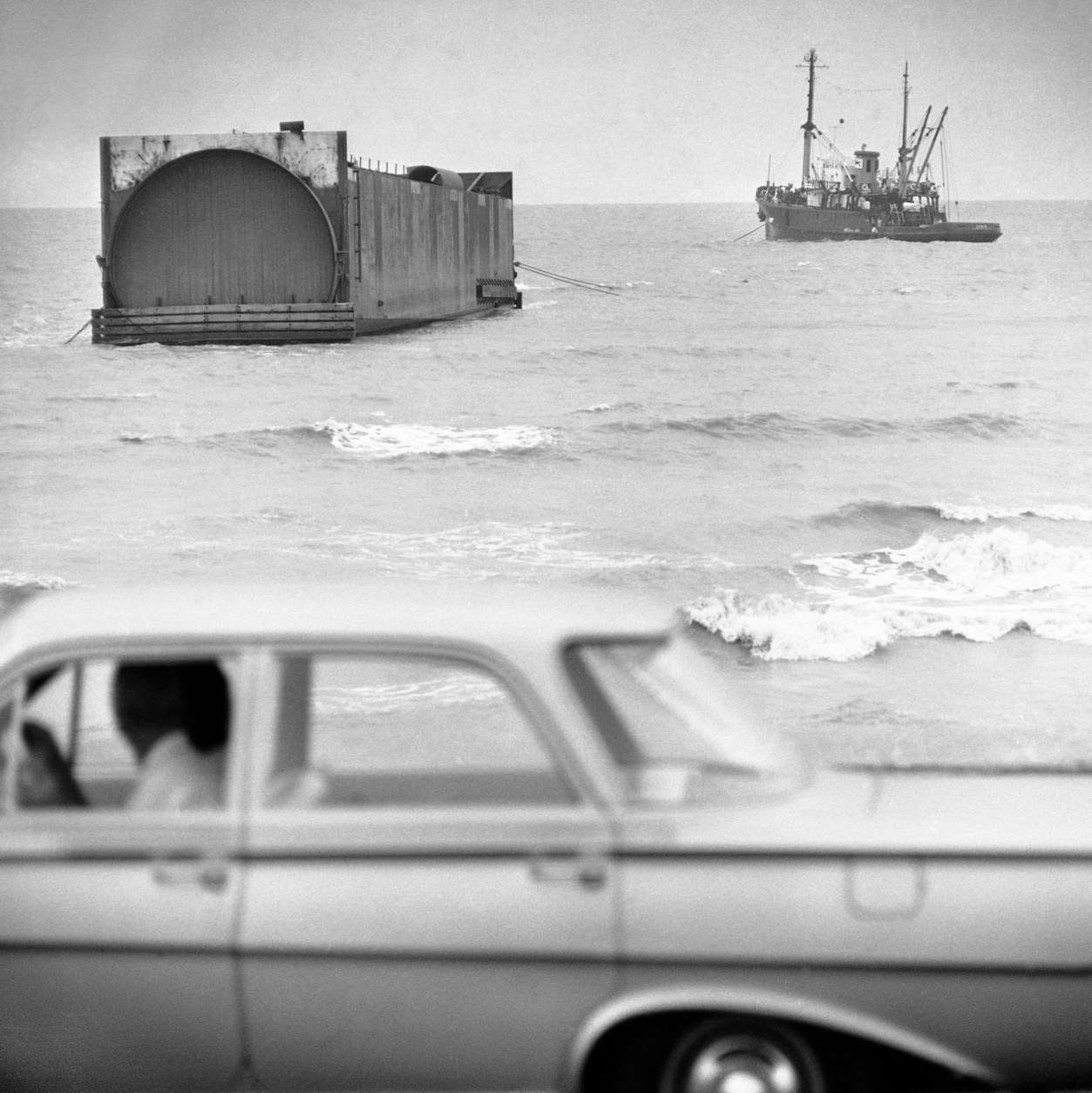
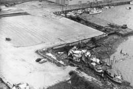
A large tugboat tied onto the 286-foot steel tunnel liner that beached itself near the seawall in Galveston, Texas on Wednesday, Sept. 15, 1961. Two of the huge liners were being towed from Orange, Tex., to Norfolk, Va., for use on a Chesapeake Bay bridge-tunnel, when the tug ran into high seas kicked by hurricane Carla. This one apparently floated 270-miles after breaking loose.
(AP Photo/Ed Kolenovsky)
AP Photo/Ed Kolenovsky
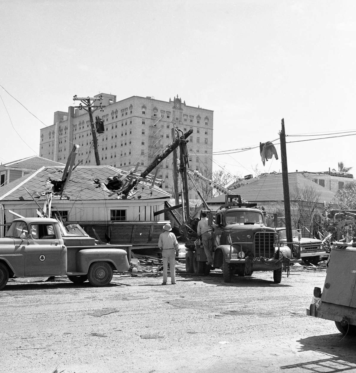
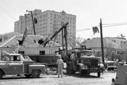
A telephone company truck lifts a snapped-off section of a pole from a hole in garage roof in Galveston, Texas on, Sept. 14, 1961. Bright sunshine and heavy equipment started to erase some of the scars of hurricane Carla on this island city.
(AP Photo/Ed Kolenovsky)
AP Photo/Ed Kolenovsky
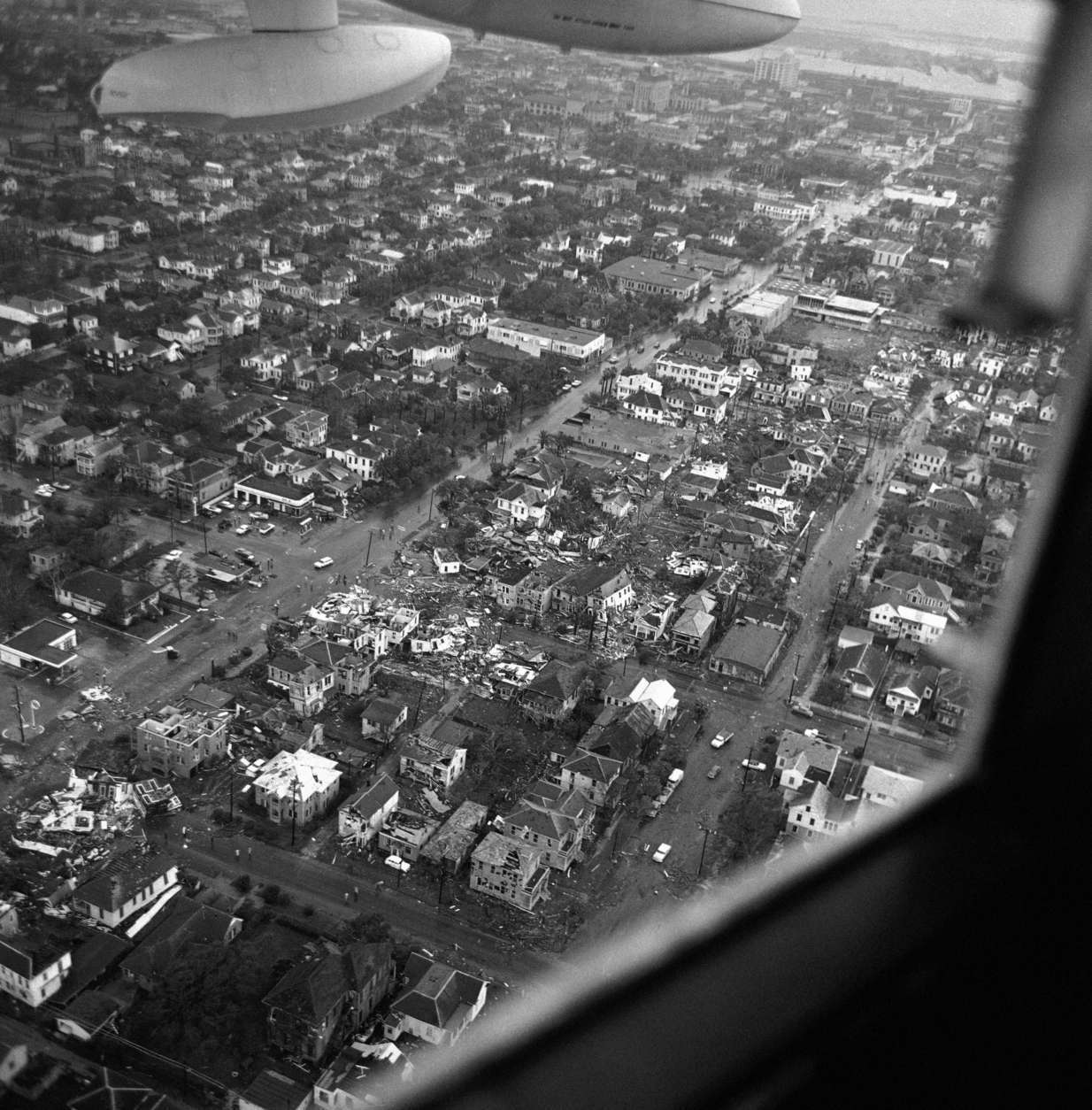
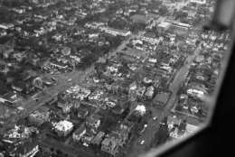
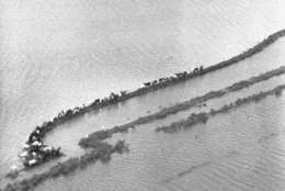
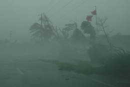
Air view shows the path of a tornado that ripped though Galveston on Sept. 13, 1961. The island city suffered heavy loss of property from Hurricane Carla and an early morning tornado.
(AP Photo/Ferd Kaufman)
AP Photo/Ferd Kaufman
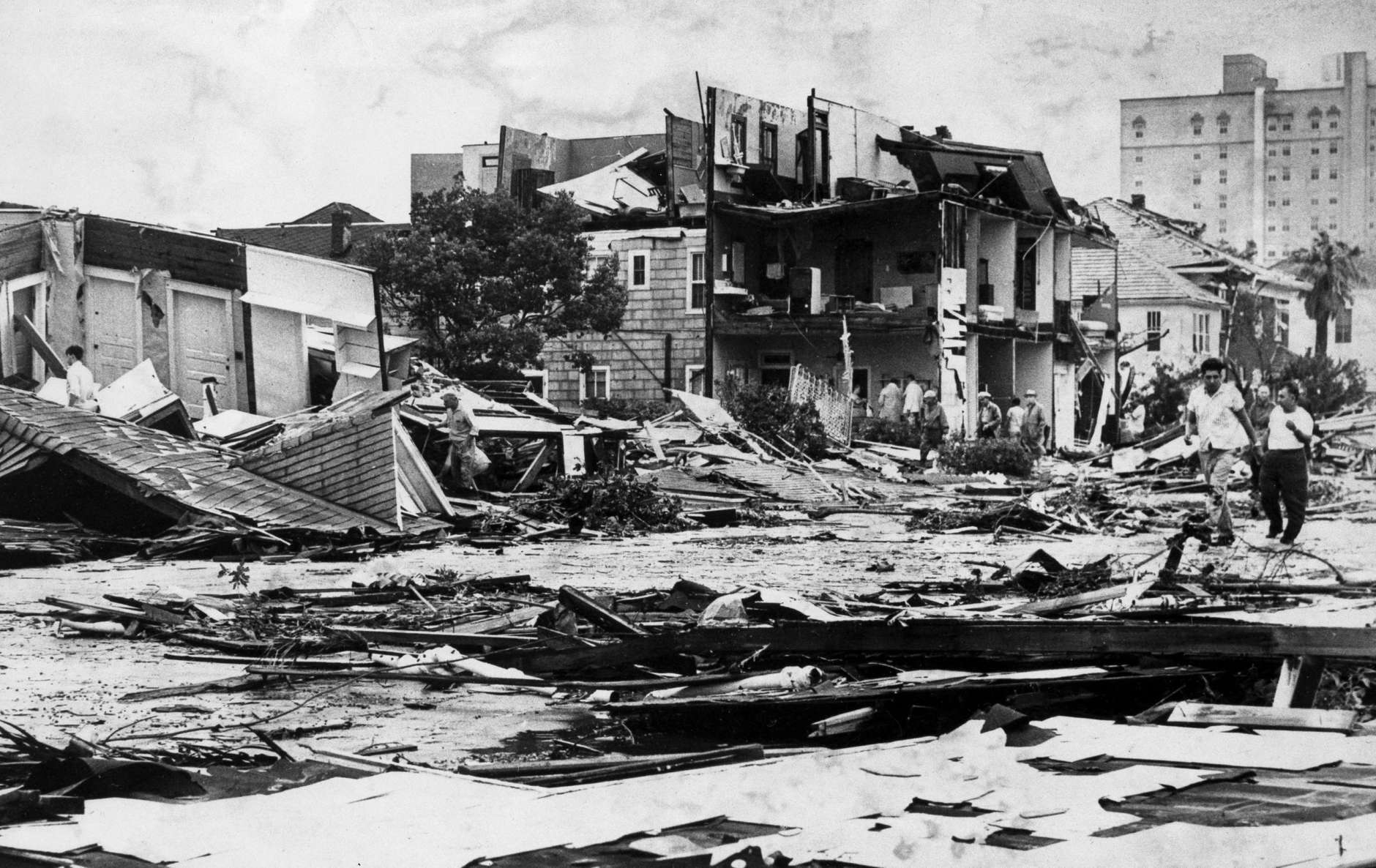
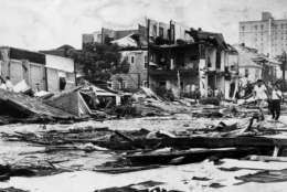
Dazed residents of Galveston, Texas, wander through debris-laden streets and amid wind-ripped homes, after enduring a double blow by Hurricane Carla and its attendant tornado, Sept. 12, 1961.
(AP Photo)
AP Photo
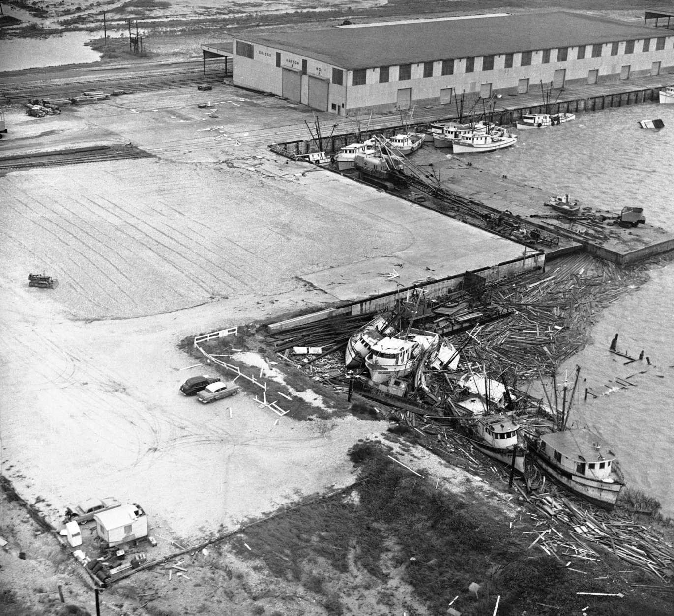
Tugboats, barges and fishing vessels litter the waterfront at Port Lavaca, Texas on Sept. 12, 1961 after hurricane Carla passed through during the night. Damage in the waterfront area of this coastal city was heavy.
(AP Photo/Ted Powers)
AP Photo/Ted Powers
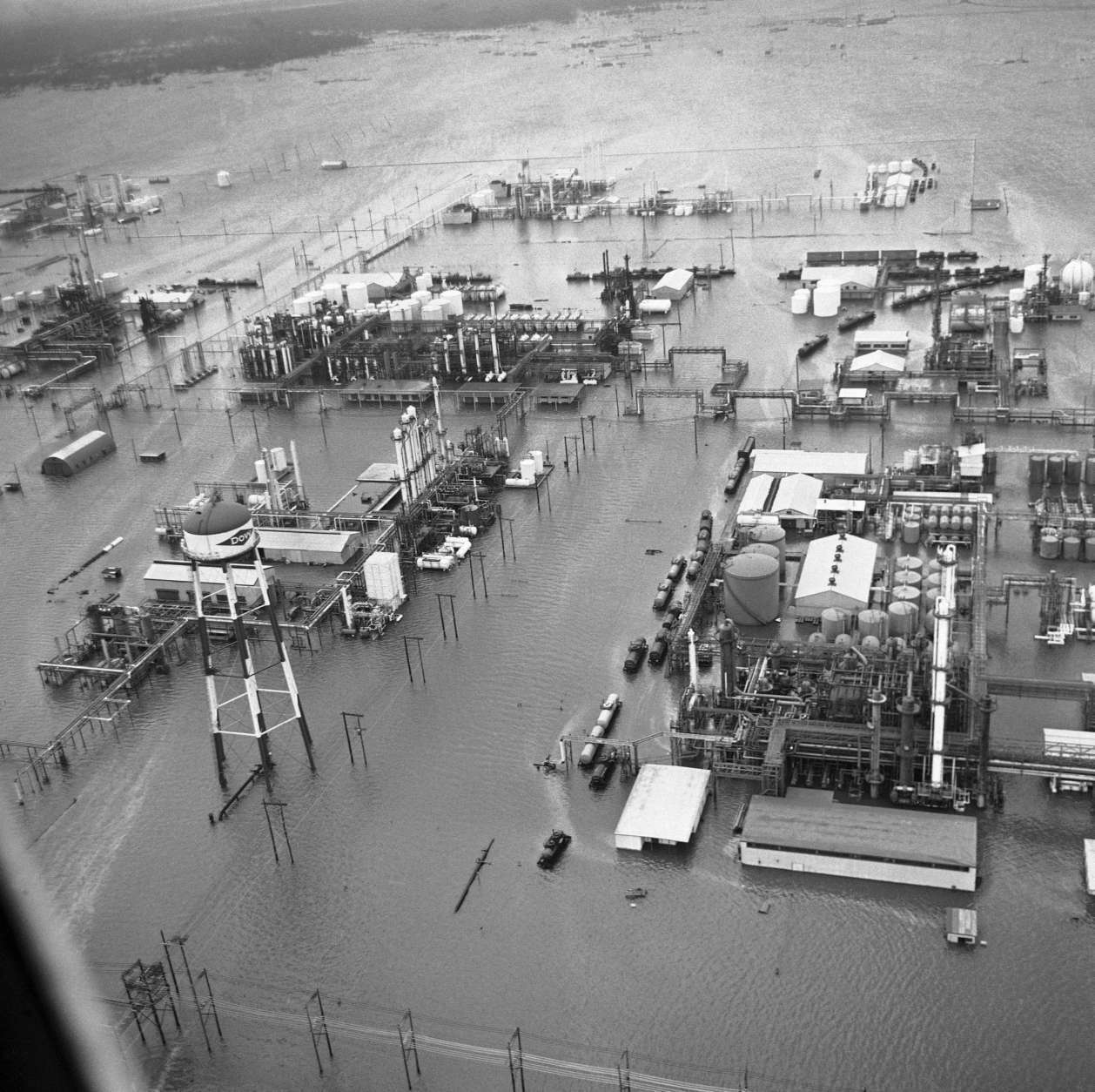
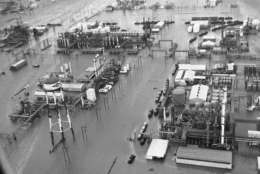
An aerial view of a portion of Dow Chemical Companys huge chemical plant at Freeport, Texas on Sept. 12, 1961. High tides, heavy rains and a break in the river levee inundated much of the city as hurricane Carla hit the Texas coast.
(AP Photo/Ferd Kaufman)
AP Photo/Ferd Kaufman
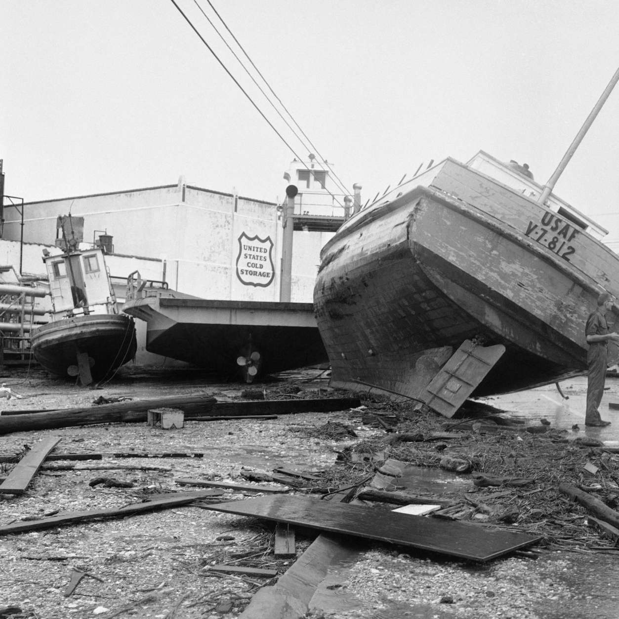
Shrimp boats at Freeport, Texas on Sept. 12, 1961, splintered and stacked one upon the other, graphically the tragic damage hurled upon the Gulf Coast by Hurricane Carla when it moved inland yesterday with winds registering up to 173-miles per hour.
(AP Photo/Ed Kolenovsky)
AP Photo/Ed Kolenovsky
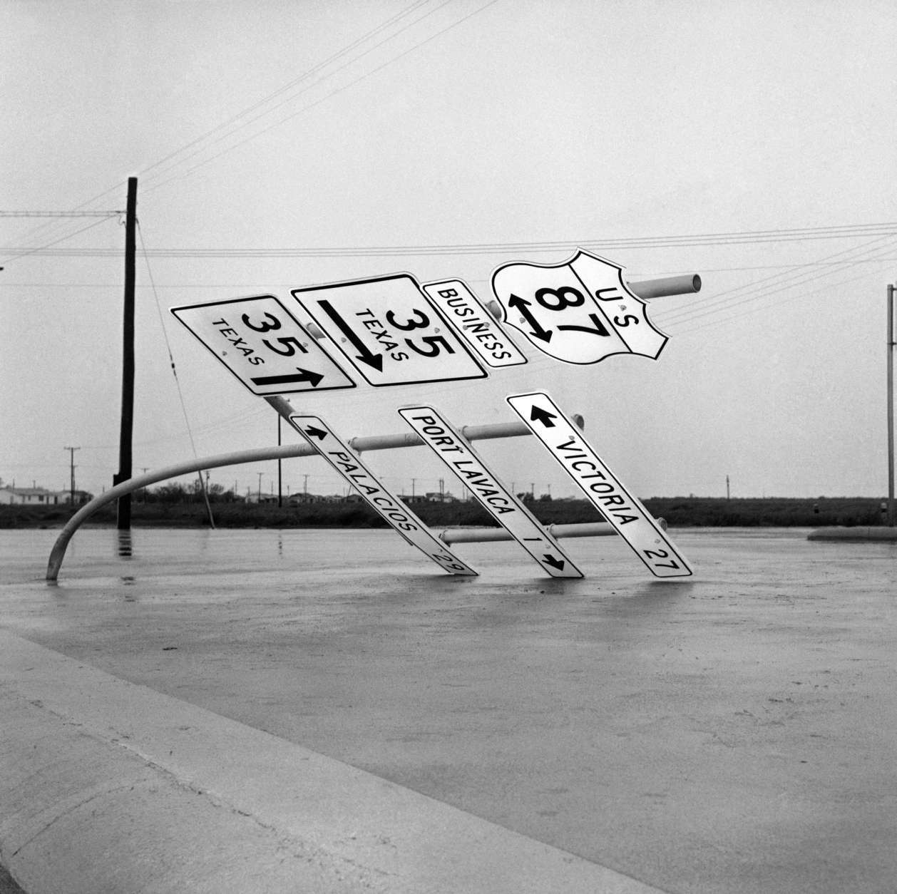
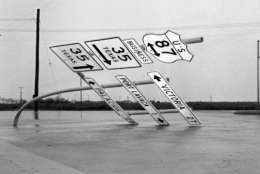
Fierce winds accompanying hurricane Carla bent this heavy steel pole holding road signs outside Port Lavaca, Texas on Sept. 12, 1961. The hurricane caused extensive damage in this coastal city.
(AP Photo/Ted Powers)
AP Photo/Ted Powers
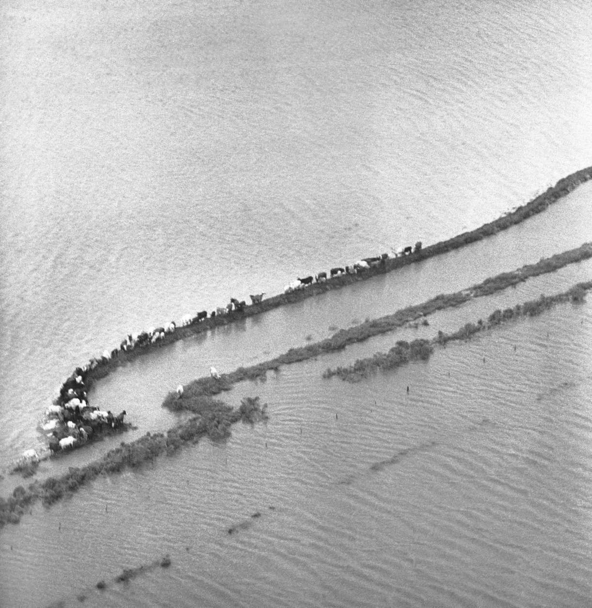
Herd of cattle just outside Freeport, Texas on Sept. 12, 1961, takes refuge on these little strands of soil escape floodwaters. Hurricane Carla dumped several inches of rain and brought unusually high tides to the Gulf coastal area when it moved inland Monday.
(AP Photo/Ed Kolenovsky)
AP Photo/Ed Kolenovsky
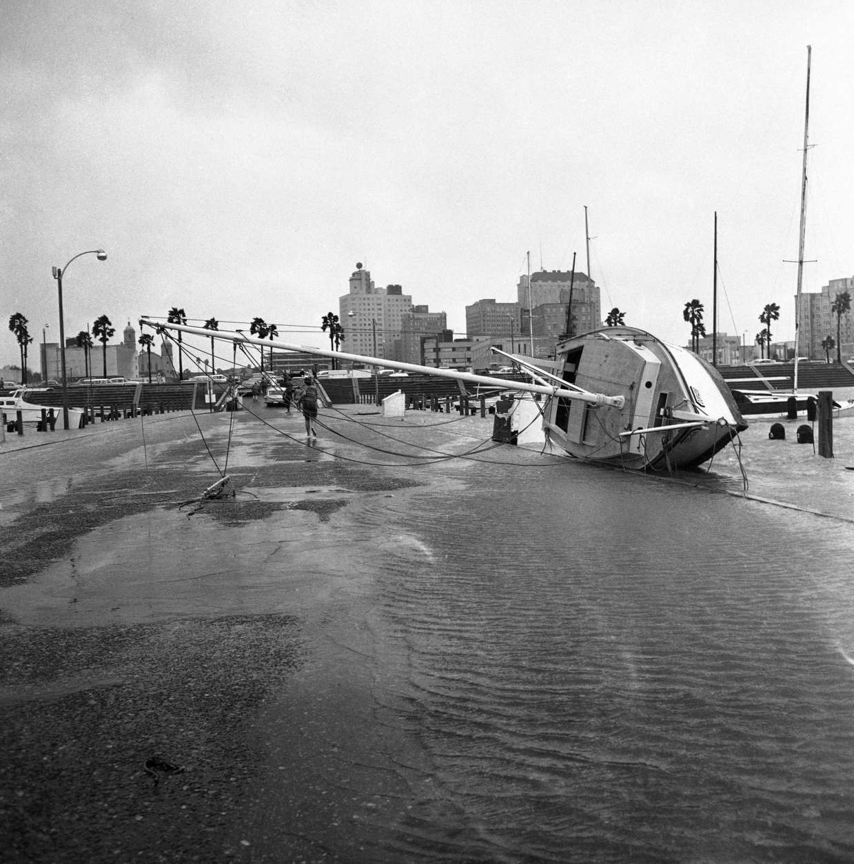
Sail boat rests on its side on a T-Head in Corpus Christi Bay on Sept. 11, 1961. The boat was blown on the pier during the hurricane winds that accompanied hurricane Carla. Downtown Corpus Christi can be seen in the background.
(AP Photo/Ferd Kaufman)
AP Photo/Ferd Kaufman
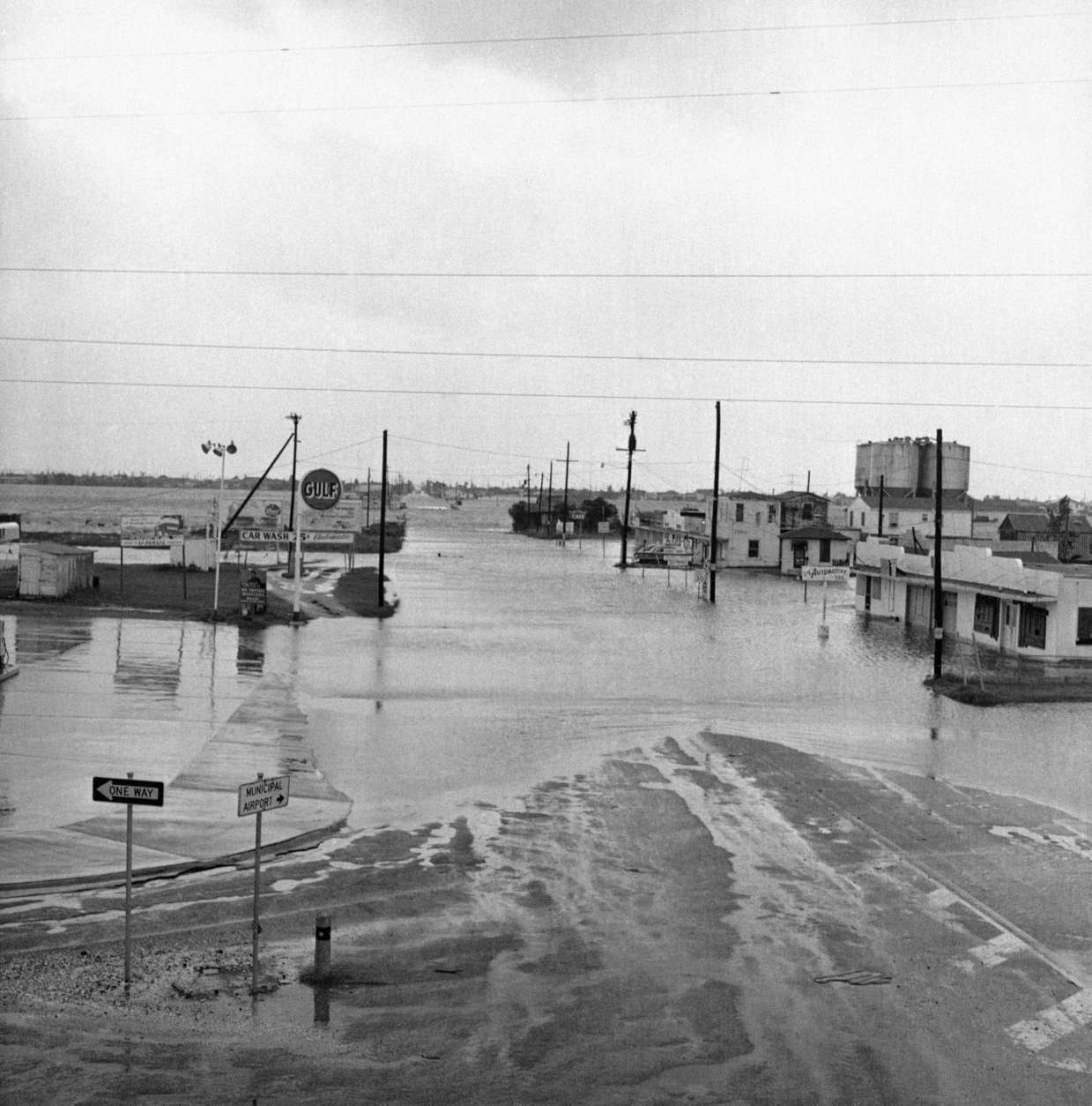
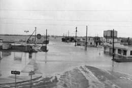
A typical scene in Galveston, Texas on Sunday, Sept. 10, 1961, was this inundated street, one of many closed by rising tides of hurricane Carla.
(AP Photo/Ted Powers)
AP Photo/Ted Powers
FILE – In this Sept. 16, 2004 file photo, waves crash against a sailboat lodged under a bridge in Fort Walton Beach, Fla., after Hurricane Ivan struck the gulf coast. Federal regulators believe a persistent oil spill in the Gulf of Mexico that began after a drilling platform was toppled during Hurricane Ivan in 2004 will continue for 100 years or more if left unchecked, according to estimates obtained by The Associated Press that provide new details about the extent of the problem.
(AP Photo/John Bazemore, File)
AP Photo/John Bazemore, File
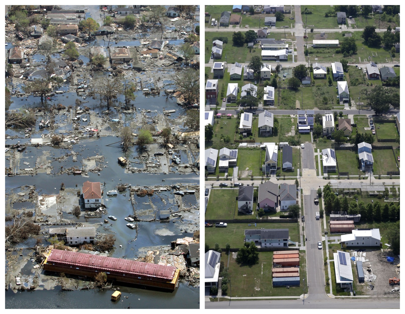
FILE – This combination of Aug. 30, 2005, left, and July 29, 2015 aerial photos shows downtown New Orleans and the Superdome flooded by Hurricane Katrina, left, and the same area a decade later. When the New Orleans Saints host rival Atlanta on Monday night, it’ll mark the 10-year anniversary of the stadium’s reopening, and a victory over the Falcons that symbolized a city’s determination to rebuild from one of the worst natural disasters in American history.
(AP Photo/David J. Phillip, left, and Gerald Herbert, File)
AP Photo/David J. Phillip, left, and Gerald Herbert, File
FILE – In this Aug. 30, 2005, file photo, the Louisiana Superdome is shown in this aerial view, which was damaged by Hurricane Katrina, surrounded by floodwaters, in New Orleans. Eleven years ago, Hurricane Katrina exposed huge gaps in the disaster response plans of Louisiana and the nation. Lessons learned from that 2005 monster storm formed the backbone of state and federal reaction as flooding ravaged 20 Louisiana parishes in Aug. 2016.
(AP Photo/David J. Phillip, File)
AP Photo/David J. Phillip, File
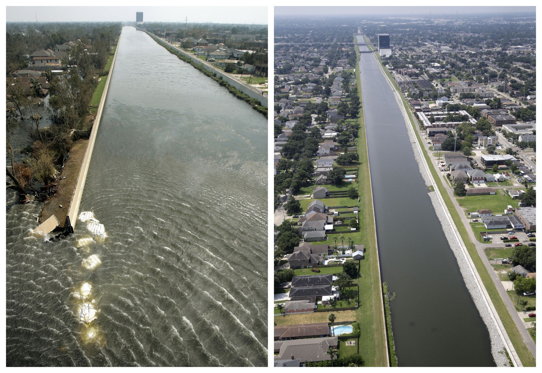
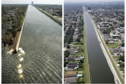
This combination of Sept. 3, 2005 and July 29, 2015 aerial photos show the 17th Street Canal flood wall breach and the Lakeview section of New Orleans flooded by Hurricane Katrina and the same area a decade later. Katrina’s powerful winds and driving rain bore down on Louisiana on Aug. 29, 2005. The storm caused major damage to the Gulf Coast from Texas to central Florida while powering a storm surge that breached the system of levees that were built to protect New Orleans from flooding.
(AP Photo/Haraz N. Ghanbari, Gerald Herbert)
AP Photo/Haraz N. Ghanbari, Gerald Herbert
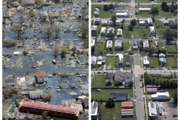
This combination of Sept. 11, 2005 and July 29, 2015 aerial photos show the Lower Ninth Ward of New Orleans flooded by Hurricane Katrina and the same area a decade later. Before Katrina, the Lower Ninth Ward was a working-class and predominantly African-American neighborhood just outside the city’s historic center.
(AP Photo/David J. Phillip, Gerald Herbert)
AP Photo/David J. Phillip, Gerald Herbert
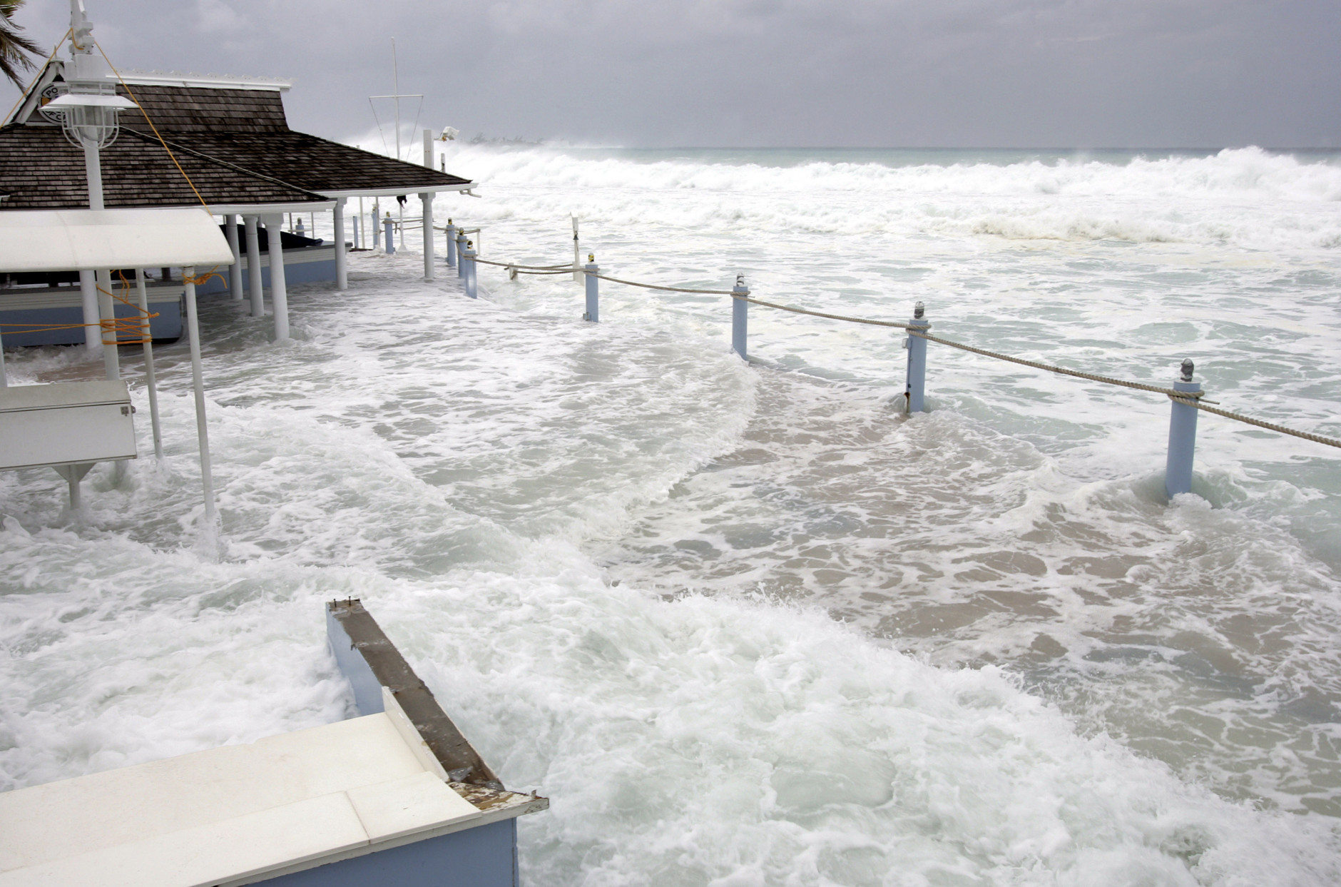
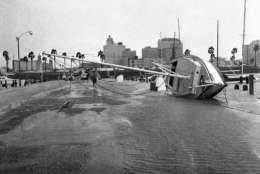
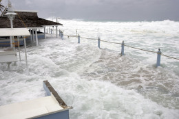
Waves reach The Wharf patio restaurant, damaging the bar and main deck, in George Town, Grand Cayman Island, Thursday, Oct. 20, 2005. Hurricane Wilma moved away from the Cayman Islands but residents and tourists are still feeling rough seas and battering waves on the south and west coasts.
(AP Photo/Caymanian Compass, Justin Uzzell)
AP Photo/Caymanian Compass, Justin Uzzell
Hurricane Wilma makes landfall in southwestern Florida in 2005.
(WTOP/Dave Dildine)
WTOP/Dave Dildine
FILE – In this Sept. 27, 2005 file photo, President George W. Bush, on board Marine One, gets an aerial tour of Cameron, La., damaged by Hurricane Rita. A decade after Hurricane Rita, Cameron Parish in coastal, southwest Louisiana still bears the scars of her wrath. Thursday, Sept. 24, 2015 is the anniversary of Hurricane Rita.
(AP Photo/Susan Walsh, File)
AP Photo/Susan Walsh, File
FILE – In this Sept. 26, 2005 file photo, search and rescue personnel walk through floodwaters in the aftermath of Hurricane Rita, in Cameron, La. An estimated 80 percent of the buildings in the town of Cameron, population 1,900, were leveled. A decade after Hurricane Rita, Cameron Parish in coastal, southwest Louisiana still bears the scars of her wrath. Thursday, Sept. 24 is the anniversary of Hurricane Rita.
(AP Photo/David J. Phillip, File)
AP Photo/David J. Phillip, File
FILE – In this Sept. 26. 2005 file photo, Search & Rescue workers make their way through the mud and water that was downtown Cameron, La., in the wake of Hurricane Rita. An estimated 80 percent of the buildings in the town of Cameron, population 1,900, were leveled. A decade after Hurricane Rita, Cameron Parish in coastal, southwest Louisiana still bears the scars of her wrath. Thursday, Sept. 24 is the anniversary of Hurricane Rita.
(AP Photo/Ric Feld, File)
AP Photo/Ric Feld, File
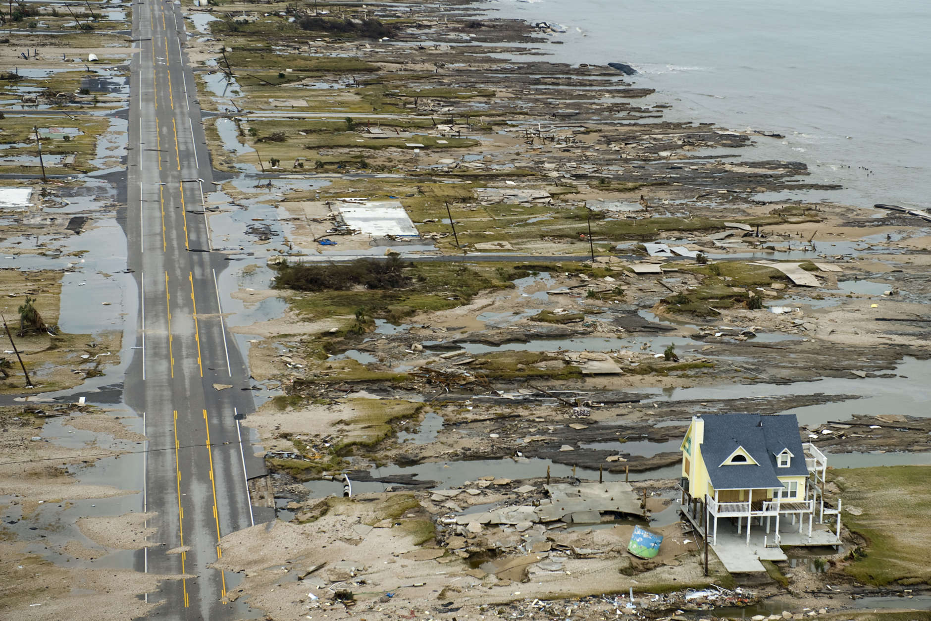
A beachfront home stands among the debris in Gilchrist, Texas on the coast of the Gulf of Mexico on Sunday, Sept. 14, 2008 after Hurricane Ike hit the area. Ike was the first major storm to directly hit a major U.S. metro area since Hurricane Katrina devastated New Orleans in 2005.
(AP Photo/Pool, Smiley N. Pool)
AP Photo/Pool, Smiley N. Pool
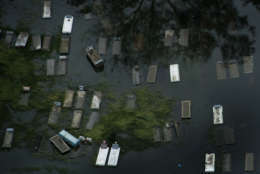
Floodwaters caused by Hurricane Ike cover a cemetery in Orange, Texas, on Sunday, Sept. 14, 2008. Ike was the first major storm to directly hit a major U.S. metro area since Hurricane Katrina devastated New Orleans in 2005.
(AP Photo/Pool, Smiley N. Pool)
AP Photo/Pool, Smiley N. Pool
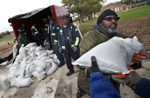
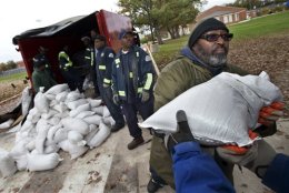
District of Columbia Department of Public Works worker Donald Jackson, right, passes a sandbag from the line of fellow workers handing out free sandbags to District of Columbia residents in Washington, Sunday, Oct. 28, 2012, ahead of Hurricane Sandy.
(AP Photo/Manuel Balce Ceneta)
AP Photo/Manuel Balce Ceneta
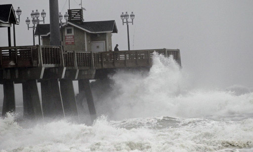
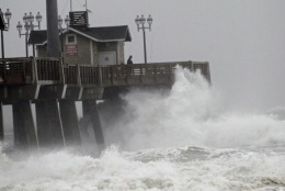
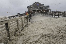
Large waves generated by Hurricane Sandy crash into Jeanette’s Pier in Nags Head, N.C.,
Saturday, Oct. 27, 2012 as the storm moves up the east coast. Hurricane Sandy, upgraded again
Saturday just hours after forecasters said it had weakened to a tropical storm, was barreling
north from the Caribbean and was expected to make landfall early Tuesday near the Delaware
coast, then hit two winter weather systems as it moves inland, creating a hybrid monster storm.
(AP Photo/Gerry Broome)
AP Photo/Gerry Broome
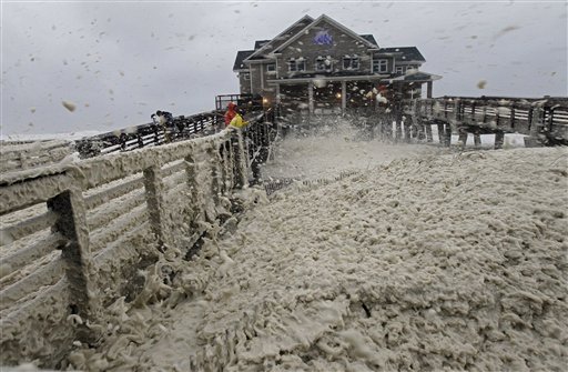
High winds blow sea foam onto Jeanette\’s Pier in Nags Head, N.C., Sunday, Oct. 28, 2012 as wind and rain from Hurricane Sandy move into the area. Governors from North Carolina, where steady rains were whipped by gusting winds Saturday night, to Connecticut declared states of emergency. Delaware ordered mandatory evacuations for coastal communities by 8 p.m. Sunday.
(AP Photo/Gerry Broome)
AP Photo/Gerry Broome
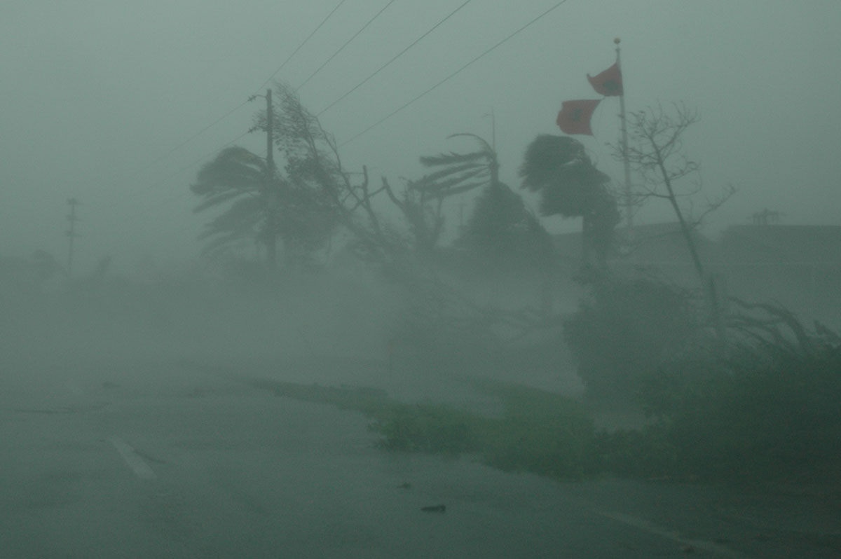
A traffic signal topped by the winds of Hurricane Harvey lies in an intersection of downtown Corpus Christi, Texas, Saturday, Aug. 26, 2017. Harvey has been further downgraded to a Category 1 hurricane as it churns slowly inland from the Texas Gulf Coast, already depositing more than 9 inches of rain in South Texas.
(AP Photo/Eric Gay)
AP Photo/Eric Gay
A dead dog lies out of the passenger window of an overturned pickup truck after Hurricane Harvey landed in the Coast Bend area in Port Aransas, Texas, on Saturday, Aug. 26, 2017. Harvey came ashore Friday along the Texas Gulf Coast as a Category 4 storm with 130 mph winds, the most powerful hurricane to hit the U.S. in more than a decade.
(Gabe Hernandez/Corpus Christi Caller-Times via AP)
Gabe Hernandez/Corpus Christi Caller-Times via AP
A power generator tips in front of Texas’ CHRISTUS Spohn Hospital in Corpus Christi, Texas, as Hurricane Harvey hits Friday, Aug. 25, 2017.
(Courtney Sacco /Corpus Christi Caller-Times via AP)
Courtney Sacco /Corpus Christi Caller-Times via AP
Wanda Carpenter hung her seven-year-old daughter Samantha at the Fulton 4-5 Learning Center after waiting out Hurricane Harvey on Saturday, Aug. 26, 2017, in Fulton, Texas.
(Courtney Sacco/Corpus Christi Caller-Times via AP)
Hurricane Harvey reached land Friday night, securing its place in history as the most furious hurricane to hit the Texas coast since Hurricane Carla in 1961. Carla killed dozens and destroyed nearly 2,000 homes.
A look at Hurricane Carla and some of the most damaging hurricanes to hit the United States since 2000: (Figures have not been adjusted for inflation)
CARLA
Starting as a tropical depression in the Caribbean Sea on Sept. 3, 1961, Carla steadily gained momentum until it was labeled a major hurricane four days later. After a few days, it became a Category 5, only to be downgraded to a Category 4 by Sept. 11, when it made landfall on Matagorda Island, a 38-mile (61-kilometer) barrier island on the Texas Gulf coast, according to the National Weather Service.
It weakened to a tropical storm after its eye hit Port O’Connor and Port Lavaca in Texas. The hurricane also impacted parts of Louisiana, Oklahoma and Illinois.
In Texas, the highest winds were about 115 mph but sustained winds in some parts hit 170 mph.
The hurricane spawned 18 tornadoes, including 10 in Louisiana and eight in Texas. Between Carla and the subsequent tornadoes, the NWS said 46 people were killed and more than 450 were injured.
Total damage was estimated at $2.36 billion with Texas suffering more than $400 million in damage. In Texas, 1,915 homes were destroyed.
___
KATRINA
Katrina crossed the tip of Florida and then swept into the Gulf of Mexico and over Louisiana and Mississippi, causing more than 1,800 deaths and an estimated $108 billion in damage and becoming the costliest hurricane in U.S. history, according to the National Hurricane Center. Most of the fatalities occurred in Louisiana, where thousands of homes and businesses in New Orleans were destroyed by strong winds and flooding. Mississippi, Florida, Georgia and Alabama also reported deaths in the 2005 hurricane, which left about 3 million people without power, some for weeks at a time.
___
SANDY
The pounding winds and storm surges of Sandy, dubbed a “superstorm” since it was extratropical by the time it made landfall, devastated the coastlines of New York and New Jersey in late October 2012, damaging at least 650,000 homes and causing about 8.5 million power outages, according to the Hurricane Center. U.S. officials preliminarily tallied at least $50 billion in damage, though some sources cite around $75 billion. There were at least 147 deaths directly tied to storm conditions, as well as a number of indirect fatalities linked to hypothermia, carbon monoxide poisoning and falling trees during the cleanup effort, the center said. Repairs to homes and infrastructure continue today.
Ike’s storm surges raised water levels across nearly the entire U.S. Gulf Coast when it hit in 2008, causing almost $30 billion in damage, mostly in Texas, Louisiana and Arkansas. At least 20 people were killed, according to the Hurricane Center. Waves battered the coasts of Texas and Louisiana, and almost 3 million people in those state lost power. Winds uprooted trees, and a number of homes were damaged.
___
WILMA
Coming near the end of 2005’s extraordinary hurricane season, Wilma caused 98 percent of South Florida to lose electricity, with experts at the Hurricane Center attributing widespread damage in the state to its large core. Trees were downed, windows shattered, roofs torn up and crops lost. All told, the U.S. reported more than $21 billion in damage, as well as five deaths.
___
IVAN
Ivan’s 10- to 15-foot storm surge in 2004 caused as much as a quarter-mile of an interstate bridge to collapse in Florida, which along with Alabama was among the hardest-hit states, according to the Hurricane Center. Thousands of homes were damaged or destroyed. Debris piled up after the storm stretched for more than three-quarters of a mile and were as tall as seven stories. Almost 2 million people experienced power outages. Ivan killed 25 people and caused more than $18 billion in damage, according to the center.
___
RITA
Rita, one of the strongest hurricanes of the record-breaking 2005 season, prompted one of the largest-scale evacuations in U.S. history, with more than 2 million people estimated to have fled the Texas coast, according to the Hurricane Center. Coming just weeks after Katrina, Rita’s wind and rain caused $12 billion in damage and killed 62 people, including many nursing home residents whose bus caught fire as they fled the storm, the center said. Nearly every structure in some coastal areas of southwestern Louisiana was destroyed, some entirely swept away.