Listen live to WTOP for traffic and weather updates on the 8s.
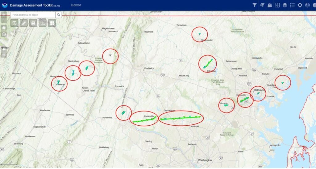
The National Weather Service has upped its tornado count to 13, nearly double its initial report, after doing an additional survey of damage from storms that blew through the D.C. area last week.
One day after storms blew through, NWS’ offices based in Sterling, Virginia, confirmed seven tornadoes had touched down on June 5 throughout the broader D.C. region; the weather service groups parts of Maryland, Virginia and D.C. in with West Virginia in its forecasts.
An update from the National Weather Service on Thursday confirmed even more tornadoes had touched down than previously believed. It also corrected that it was actually two separate tornadoes that tore through Montgomery County, not one tornado that traveled for 12 miles as investigators initially had reported.
Most of the recorded tornadoes were an EF-1, with an EF-0 being the weakest on the five-point Enhanced Fujita scale.
The National Weather Service issued 22 tornado warnings on June 5, 7News First Alert meteorologist Brian van de Graaff said, which is the fourth most in one day since 1986.

What actually happened in Montgomery Co.
Things kicked up in the WTOP listening area on June 5 after the National Weather Service said a mini-supercell thunderstorm formed southeast of Leesburg, near the Potomac River. A tornado touched town in Poolesville at around 7 p.m. It was so powerful, a shipping container that weighs around 9,000 pounds was lifted off the ground slightly, and bounced twice as it was moved 100 yards.
That storm had peak wind gusts around 105 mph, was 9.1 miles long and 150 yards wide.
The NWS originally believed that tornado kept traveling to Gaithersburg, but further surveying and radar imagery discounted that projection.
An update from the NWS found the tornado traveled northeast and uprooted trees in Seneca Creek State Park before dying down.

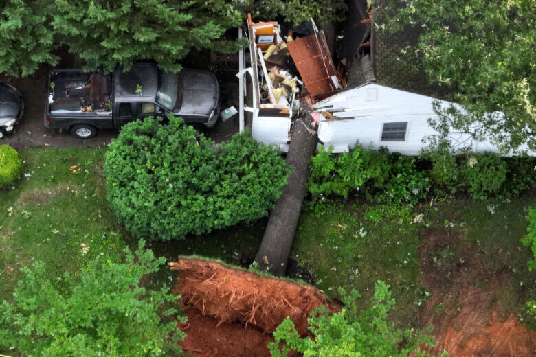
Then, a second tornado formed in Gaithersburg, just east of the park, around 7:30 p.m. That twister moved into the city and caused significant damage to a housing development east of its city hall, according to the report.
“One large oak tree with a trunk of about three feet was uprooted, and fell into a house on Dogwood Drive, where five occupants were injured and transported to the hospital,” NWS wrote.
Those five people injured were adults, according to the Montgomery County Fire and Rescue Service. Four had injuries considered non-life-threatening and the fifth had more serious injuries.
Those people were the only ones who reported being injured during any of the tornadoes, NWS said.
The Gaithersburg tornado was 15.2 miles long, 150 wide and had peak wind gusts of 95 mph.
Tornado damages detailed, double
Most of the newly confirmed tornadoes took place in West Virginia.
A second tornado was confirmed in the Baltimore area in the Canton neighborhood with the help of video taken from a resident. That tornado was 0.4 miles long, 90 yards wide and reached 70 mph. It was rated as an EF-0, a weaker storm than many of the others that evening, causing little damage outside of knocking down a pine tree and tossing some branches around.
In the previous report, NWS had only confirmed a tornado in southern Baltimore County.
The tornadoes in bold below are the ones confirmed by NWS on Thursday:
- Poolesville, Maryland
- Gaithersburg, Maryland
- Eldersburg, Maryland
- Carrol County Airport, Maryland
- Kearneysville, West Virginia
- Shepherdstown, West Virginia
- Boonsboro, Maryland
- Baltimore City (Canton neighborhood), Maryland
- Southern Baltimore County, Maryland
- Middle River, Maryland
- Inwood, West Virginia
- Leesburg, Virginia
- Columbia, Maryland
The tornado with the highest peak wind gusts was in Eldersburg in Carroll County, where an EF-1 tornado reached 110 mph, according to the report.
Get breaking news and daily headlines delivered to your email inbox by signing up here.
© 2024 WTOP. All Rights Reserved. This website is not intended for users located within the European Economic Area.


