Sign up for WTOP alerts to get up-to-date information on storm-related traffic disruptions and closings, sent to your email or phone.
The full force of winter could be coming to the D.C. region early in 2024, with an evolving storm system that could result in snowfall in parts of the area this weekend. Here’s what you need to know.
Meteorologists are tracking a pattern that could become more active, causing drops in temperatures across portions of the East Coast, more specifically around the mid-Atlantic.
“So, you got a storm system potentially evolving as it moves up the coast, interacting with the cold air,” 7News First Alert Chief Meteorologist Veronica Johnson said. “It is looking more consistent now, from run to run, the guidance that we as meteorologists look at, that we have favorable conditions to get a winter-style storm around here, producing some snowfall.”
When will it all happen? Johnson said that it looks like the heaviest of rain and snow will be Saturday afternoon through Sunday morning.
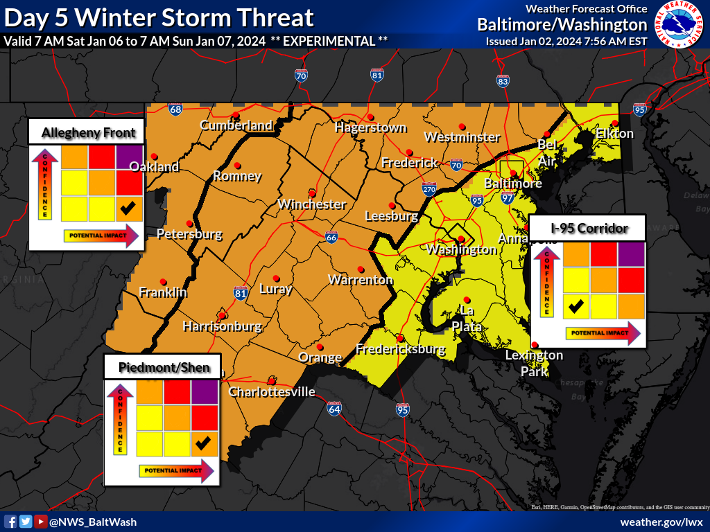
The National Weather Service is predicting an “enhanced winter storm threat,” which means increased potential for more significant travel impacts and closures.
Johnson said the enhanced threat doesn’t cover the entire area, but it includes areas north and west of D.C., such as western Howard, northern Montgomery counties, and Frederick, Hagerstown, Cumberland, and Frostburg in Maryland. In Virginia, the enhanced risk includes Loudoun, Fauquier, as well as Rappahannock, Culpeper and even Madison and Greene counties, and Luray.
Currently, the D.C. metro area is under a slight threat, as are places along the Interstate 95 corridor and off to the east, including along Maryland 301 and even the Northern Neck and Maryland’s Eastern Shore.
“That means that if the storm materializes, it may cause travel disruptions,” Johnson said, adding that there is still a lot of uncertainty in the storm’s track, the freezing line between rain and snow and how much to expect of each.
“What we can tell you is that it is looking cold enough for snow to fall for several hours, especially Saturday night through Sunday morning,” Johnson and 7News First Alert meteorologist Mark Peña said.
- Listen to WTOP online and on the radio at 103.5 FM or 107.7 FM.
- Current traffic conditions
- Weather forecast
- Closings and Delays
How to prepare
If the storm materializes, it may start out as rain and then switch over to snow for a couple of hours. Johnson said there is the potential for winds to increase.
“We could be looking at some wind gusts of around 30 mph or greater over the weekend, especially as you head east over the Bay Bridge and towards Maryland’s Eastern Shore. So there may be, if it does materialize, windblown snow,” Johnson said.
Meteorologists will have a better handle on the forecast in the coming days, but Johnson said the way it currently looks, it is “becoming more favorable that we will have a few inches of snowfall.”
In the event that it does snow, it’s a good idea to start getting your vehicle prepared for treacherous driving conditions. Since the storm might happen over the weekend, there likely won’t be as many vehicles on area roadways.
“But for anyone that does have any driving or traveling to do … this may turn into a storm system where we say, ‘Stay home if you can,'” Johnson said.
Some things to do in preparation include getting a bag in the car with items you may need, such as boots, blankets and snacks, in case you get stuck on the road.
And continue to check back for the updated weather forecast.
“Not only [will] our confidence in what we’re going to get [be] increasing, but the message of how to prepare, also changing as we go from it being very low confidence in some areas to becoming more confident and more certain, getting closer to the time period when that storm system forms and makes its way into our area,” Johnson said.
Above-average snowfall expected for DC area this winter
This winter could be the most active winter the region has seen in more than five years.
“We know based on the pattern that we’re in El Niño,” Johnson said. And it’s a strong El Niño that is going to continue into early spring.
“Again, the jet stream if it aligns itself just right up the coast and interact[s] with … cold air … we increase our potential to get snowstorms,” she said. “And you should really prepare for a very active period to come.”
If the storm happens this weekend, it comes on the 28th anniversary of the Blizzard of ’96, which produced significant snow also on a weekend, with road and transit impact lingering well into the workweek.
But this season’s biggest storms of the season are predicted for February, with a possibility of a nor’easter or two.
Get breaking news and daily headlines delivered to your email inbox by signing up here.
© 2024 WTOP. All Rights Reserved. This website is not intended for users located within the European Economic Area.