The five-day warm streak has become the earliest stretch of 60-degree temperatures in D.C. — and now a dash of light snow is in the forecast.
While the D.C. area prepares for the first snowfall of the season late this weekend, the recent warm stretch has officially gone into the record books.
High temperatures from New Year’s Day through Thursday, Jan. 5 reached or exceeded 60 degrees in the District. The previous record for the earliest five-day streak of 60-degree days was Jan. 2 to Jan. 6, 1998.
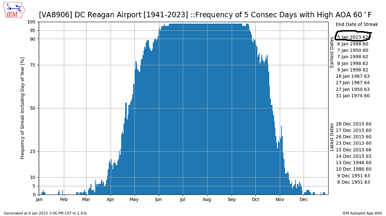
Another statistic that stands out: The average temperature through Thursday, Jan. 5, was an astonishing 55.6 degrees. This is the warmest start to January on record for Washington. The previous warmest first five days in January was in 1950, when the average temperature was 54.5 degrees.
What’s next? Friday has seen a return closer to the norm, and the weekend will finally be a chance to settle into an average early January temperature trend.
A disturbance pushing from the mid-Mississippi Valley to the southern mid-Atlantic will have just enough cold air to work with on Sunday evening for a dash of light snow inside the Capital Beltway. Snow isn’t expected to accumulate, because snowfall rates will be too light to overcome warm pavement and ground temperatures.
However, along and south of Interstate 66 west of the District to the Blue Ridge can expect a dusting to half-inch of snow accumulation on the grass and colder surfaces. The time frame to watch out for the snow is between 5 p.m. to 9 p.m. Sunday.
- Listen to WTOP online and on the radio at 103.5 FM or 107.7 FM.
- Current traffic conditions
- Weather forecast
- Closings and Delays
- Sign up for WTOP alerts
Forecast
Friday night: Clouds slowly clearing. Be on the lookout for the full moon! Low in the mid 30s; upper 20s in the far western and northern suburbs.
Saturday: Sunshine fading behind clouds and turning breezy. Highs in the lower 40s.
Sunday: Light snow developing in the afternoon, changing to rain. Less than an inch snow accumulation on grassy spots. Highs in the upper 30s.
Monday: Partly sunny and breezy. Highs in the upper 40s.