Rain is filling back in, and another round of steady rain is expected through the evening. pic.twitter.com/bLUfIykpoV
— NWS DC/Baltimore (@NWS_BaltWash) December 15, 2018
Lake Barton in the Burke area of @fairfaxcounty over-flowing a little already. Someone is honking their approval of this! #fcfrd #fairfaxcounty pic.twitter.com/UhiJc3QV6p
— Fairfax Fire/Rescue (@ffxfirerescue) December 15, 2018
Update - Brighton Dam Rd., near Bordly Drive, Brookeville, IAO overflowing Hawling’s River, ~650p (intial dispatch) @mcfrs boat crews rescued/assisted 6 people from 2 stranded vehicles in high water (several feet & rising), EMS says everybody ok pic.twitter.com/rU0ttd2B45
— Pete Piringer (@mcfrsPIO) December 16, 2018
Units on scene of water rescue Chapel Road at Cold Point Road in Clifton. Crews in process of removing one occupant from vehicle. #TurnAroundDontDrown #fcfrd #fairfaxcounty pic.twitter.com/Lcby1Gzgk5
— Fairfax County Fire/Rescue (@ffxfirerescue) December 16, 2018
UPDATE- water rescue Chapel Road at Cold Point Road in Clifton. Occupant safely rescued from vehicle. #TurnAroundDontDrown #fcfrd #fairfaxcounty pic.twitter.com/v5QgUT1SHc
— Fairfax County Fire/Rescue (@ffxfirerescue) December 16, 2018
WASHINGTON — The D.C. area broke a century-old rainfall record this weekend, and the rain keeps coming with flood watches and warnings in effect for the entire WTOP listening area.
Saturday has been steady with rainfall, and while it’s a refreshing break from the longest rain-free stretch of the year, the rain isn’t expected to stop until Sunday evening.
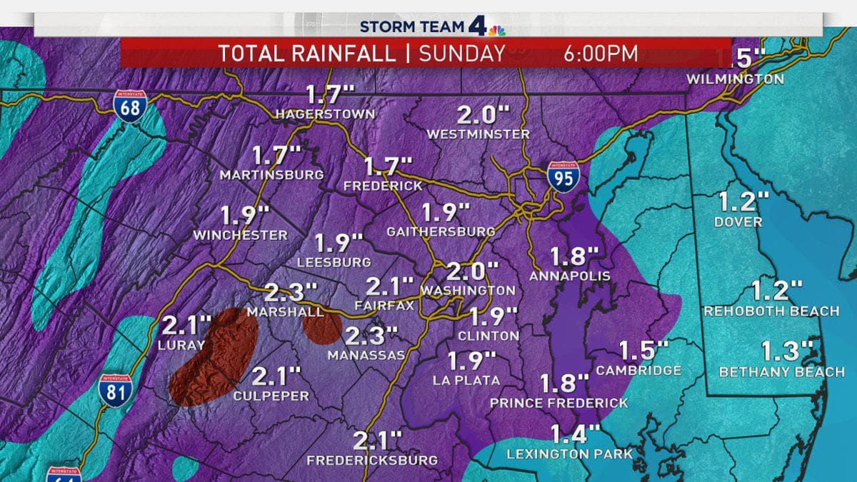
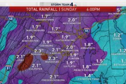
“Rain will continue to fall [Saturday] and through your Sunday with another 1 to 2 inches possible of rain accumulation before it is all said and done by Sunday night,” said Storm Team 4 meteorologist Lauryn Ricketts said. “Rain will continue overnight turning to more showery activity tomorrow.”
As of 3:09 p.m., D.C. has a rainfall total of 1.14 inches in the last 24 hours, says Storm Team 4 meteorologist Somara Theodore.
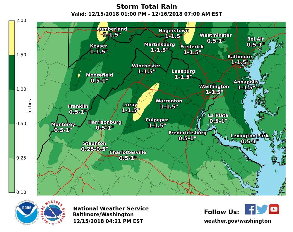
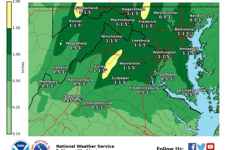
The National Weather Service has issued a flood warning for Loudoun, Fairfax, Fauquier and Prince William counties in Virginia until 7:30 a.m., as 1 to 1.5 inches of rain is forecast.
A flood warning has been issued until 1:30 a.m. for D.C., Montgomery County, areas of Prince George’s County and Arlington County.
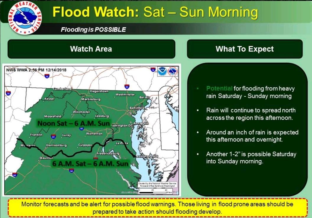
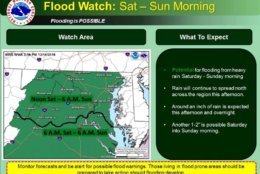
A Flood Watch is also in effect for most of the WTOP listening area from Saturday afternoon until early Sunday at 6 a.m.
Moderate flooding is forecast in the following rivers.
- Starting Sunday evening, Potomac River at Point of Rocks is under a flood warning, which affects Loudoun and Frederick counties. The water is expected to rise above flood stage by late Sunday evening and crest near 22.3 feet by early Monday morning. As of 3 p.m. Saturday, the stage was 4.4 feet and rising, as the rain continues to pummel down. The flood stage is 16 feet.
- The Potomac River at Edwards Ferry is under a flood warning, which affects Montgomery and Loudoun counties, from Sunday evening until further notice.
- The Rappahannock River at Remington is under a flood warning affecting Culpeper and Fauquier counties from Saturday evening until late Sunday night.
- The Rappahannock River at Fredericksburg is under a flood warning, which affects Stafford County, from Sunday morning to Sunday evening.
- A flood watch is in effect starting Monday morning for the Potomac River at Little Falls, which affects Montgomery, Fairfax and Loudoun Counties.
Wet roads causing traffic troubles
“The key take-away is that the weekend will be pretty soggy for Christmas and holiday shopping so plan for wet roads and ‘pack your patience’,” Storm Team 4 meteorologist Steve Prinzivalli said.
WTOP’s Traffic Center is reporting multiple flooded roads in the area. WTOP’s Dave Dildine says that a lot of spinouts have occurred on highways and a lot of roads have gone underwater “You’ll want to take it slow with your headlights on.”
About three water rescues have been reported across Fairfax County.
Fairfax County Fire and Rescue personnel responded to a person trapped in a vehicle stuck in water at Woodburn Road and Robey Avenue. They also responded to two other water rescues: One at Fairfax Station Road at Moonpatterns Trail and another at Old Courthouse Road and Besley Road.
- On the Capital Beltway’s Outer Loop on the American Legion Bridge, a right lane is currently blocked by the street flooding.
Maryland
- In Maryland, street closures are in effect by the street flooding at MD-450/Defense Highway west of St. Stephens Church Road.
- Drivers on Brock Bridge Road should proceed with caution by the street flooding between MD-197 and Patuxent River.
Virginia
- All lanes on Woodburn Road are blocked by the street flooding between Spicewood Drive and Robey Avenue.
- Old Courthouse Road is blocked by the street flooding both ways near Besley Road.
- Street closures are scheduled due to flooding on Shreve Mill Road west of Sycolin Road.
- All lanes are blocked by the street flooding at Edwards Ferry Road Northeast between Battlefield Parkway and Red Rock Way.
What’s in store for Sunday
Sunday will be still be unsettled as the upper-atmospheric low pressure center will pass overhead, producing additional light showers with a few, wet snowflakes possible in the mountains but nothing significant. There will be some dry stretches, too, but it will be pretty damp day.
Record breaking rain, below average temps
Until Friday, it was the longest rain-free stretch of the year for the area.
Around 6:30 a.m. Saturday, 2018 officially become D.C.’s wettest year, breaking a record from 1889, Ricketts said.
While temperatures in the area have been below average for much of December, the trade-off was that most parts of the area were dry for 11 days. That’s the longest precipitation-free stretch since a 21-day dry stretch in 2017 from late September into early October.
Current conditions
Forecast
A flood watch is in effect for the area Saturday into early Sunday, which could cause flooding of small streams, creeks and urban areas.
- Sunday: Cloudy and cooler with lingering showers but some dry patches. Highs in the low to mid 40s.
- Monday: Becoming windy and partly to mostly sunny. Highs around 50 degrees.
- Tuesday: Breezy and sunny with cooler temperatures around 40 degrees.
It will turn rather breezy late Monday, as a cold front approaches the area, Prinzivalli said. In the wake of the front, blustery northerly winds will bring cooler air back into the area with highs in the middle 40s — seasonable for the middle of December — under a partly sunny sky.
Wednesday should be dry but a fresh storm may bring a batch of showers late Thursday into Friday.
For the latest traffic conditions visit WTOP’s Traffic Center.
WTOP’s Abigail Constantino contributed to this report.