145pm: The Flash Flood Watch has been expanded to include the Washington DC metro area through this evening. pic.twitter.com/KVVthkc4gj
— NWS DC/Baltimore (@NWS_BaltWash) August 11, 2018
A Flash Flood Watch has been issued for northern Maryland including the Baltimore metro area through late tonight. Heavy showers and thunderstorms are likely this afternoon and evening. Be extra alert for flooding and rapidly changing conditions. pic.twitter.com/VcEAGjOVUq
— NWS DC/Baltimore (@NWS_BaltWash) August 11, 2018


WASHINGTON — Rain, thunderstorms and flash flood watches are in the forecast Saturday with many outdoor concerts and events on the schedule for the D.C. area.
Showers are expected throughout the day with a few thunderstorms possible by the afternoon as temperatures top out in the mid to upper 80s with mostly cloudy skies, said Storm Team 4 meteorologist Lauryn Ricketts.
There will be plenty of good pool time today but watch for some storms to develop during the afternoon! A mix of sun and clouds today with temperatures topping out near 90 degrees. pic.twitter.com/TymQ7BfcDN
— Lauryn Ricketts (@laurynricketts) August 11, 2018
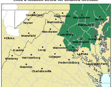
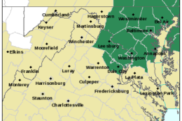
The National Weather Service issued a flash flood watch for the following areas until 1 a.m.:
D.C.
Maryland
- Anne Arundel County
- Baltimore County
- Baltimore City County
- Carroll County
- Howard County
- Montgomery County
- Prince George’s County
Virginia
- City of Alexandria
- Arlington County
- Fairfax County
- Loudoun County
- Prince William County
A flash flood watch means that conditions may develop that lead to flash flooding.
The NWS suggests those in the areas of the flash flood watches to monitor the forecast and be prepared to take action should flash flood warnings be issued.
Forecast
Some showers are expected on Sunday as well as the weather is expected to be warm and humid with temperatures in the 80s, said Ricketts.
Saturday night: Warm and muggy, with patchy fog. Temperatures in the upper 60s to low 70s.
Sunday: Mostly cloudy, warm and humid, with scattered showers in the afternoon and evening. Temperatures in the low to mid 80s.
Monday: Cloudy with showers and thunderstorms; otherwise, warm and muggy. Temperatures in the low to mid 80s.