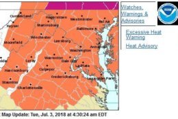
Another day, another Heat Advisory in effect for the afternoon and early evening for the entire area. Excessive Heat Warnings in the Susq. Valley in PA where criteria is lower for similar conditions. Mid 90s highs, Heat Index 100-105. pic.twitter.com/VjSA0ZYQSM
— Met. Matt Ritter (@MetMattRitter) July 3, 2018
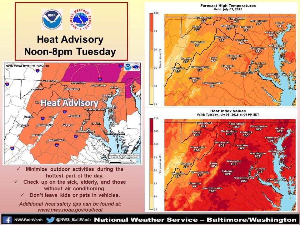
Another heat advisory for the area. Dangerous heat this afternoon with poor air quality. Try to limit your time outdoors, wear light & loose clothing, drink plenty of water, stay in the shade or AC and wear SPF 30+ if you'll be outside. @nbcwashington pic.twitter.com/yIND6gYJqu
— Sheena Parveen (@SheenaParveen) July 3, 2018


WASHINGTON — A toasty Tuesday after days of heat advisories may make you want to shake your fist at the sun, but take solace in knowing the week’s lingering heat won’t ruin your Fourth of July plans.
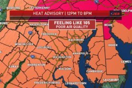
The situation got worse Tuesday afternoon — Storm Team 4 meteorologist Lauryn Ricketts said at about 2:30 p.m. that an Excessive Heat Warning was in effect for D.C., Fairfax County in Virginia, and Howard, Baltimore, Montgomery, Prince George’s, Anne Arundel and Calvert counties in Maryland until 8 p.m.
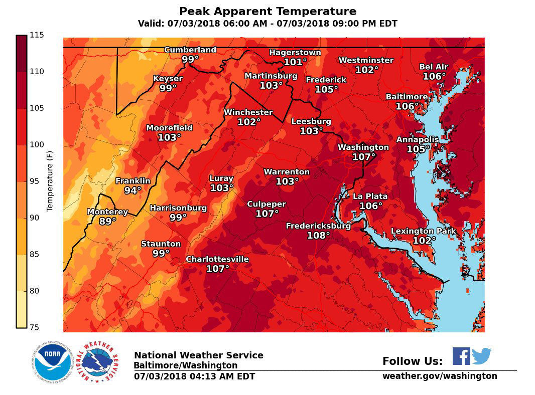
It was a step up from the Heat Advisory that was also in place for the rest of the area through 8 p.m. Ricketts said that the air temperatures all over the region are in the 90s, with heat indexes between 100 and 113.
Storm Team 4 meteorologist Steve Prinzivalli said July 3 was the hottest day of 2018 thus far. The official high at Reagan National Airport was 97 with a heat index of 110 degrees.
Tuesday also marked the fifth day of a heat wave with highs in the 90s.
Storms are possible in the afternoon and evening hours, staying mainly west of I-81, said Storm Team 4 meteorologist Amelia Draper.
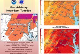
Take a look at how hot it feel tomorrow afternoon! More dangerous heat is in the forecast with another heat advisory in effect from noon until 8PM. Updates to July Fourth and when relief arrives on News 4 at 11. pic.twitter.com/nZrX3unnC7
— Amelia Draper (@amelia_draper) July 3, 2018
Prinzivalli says the chances of thunderstorms are diminishing, leaving most of the WTOP listening-area with partly cloudy skies and lows in the 70s.
Forecast
Tuesday night: Partly cloudy with temperatures dipping down into the high 70s.
Wednesday: Fourth of July will stay hot with temperatures in the 90s and a heat index in the afternoon of about 100.
Thursday: Increase in cloudiness, but it remains hot and humid with temperatures in the low 90s and a heat index near 100. Storms are possible, but mainly west of the D.C. metro.
Friday: Partly to mostly cloudy, with rain and storms likely in the afternoon, and temperatures finally dipping into the upper 80s.
Beat the heat
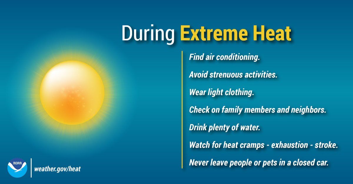
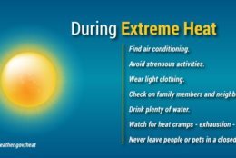
Experts warn residents to be “heat smart.” Here are some things you can do to help beat the heat:
- Limit strenuous outdoor activities.
- Don’t leave kids or pets in a closed car.
- Drink more water.
- Drink less caffeine and alcohol.
- Check on senior friends and neighbors.
- Take frequent breaks.
- Get medical help if you stop sweating.
- Adults should take corrective action, and children should seek help, if they feel nauseous, their face feels like it’s burning or they have muscle cramps.
- Make sure outdoor pets have ample shade and water.
The Centers for Disease Control and Prevention has specific recommendations for the symptoms of heat exhaustion and the even-more serious heat stroke.
Heat exhaustion
- Nausea or vomiting
- Cold, pale, clammy skin
- Heavy sweating
- Fainting
“Heat exhaustion is on the milder side; that’s when you first feel that you’re dehydrated, you’re sweating a lot, you’re nauseous,” said Dr. Eric Shobitz, a pediatric emergency doctor at Adventist HealthCare Shady Grove Medical Center.
Under those circumstances, you should move to a cooler location, loosen your clothes, lie down, apply wet, cool cloth to as much of your body as possible and sip water. If you continue to vomit, seek medical help right away.
Heat stroke
- Body temperature above 103 degrees
- Hot, red, dry or moist skin
- Fast and strong pulse
- Possible unconsciousness
Looking for ways to keep cool? Here are some public spaces and outdoor pools in the area that will help you beat the heat.
“Especially for kids, cooling off with a swim is helpful, but still [you have to] take safety measures to stay cool,” said Dr. Shobitz.
“It’s good to be in the water, but I would say make sure you keep your hydration going and be somewhere where it’s safe, where there are lifeguards watching the children,” he added.
Beach forecast
Tuesday is a sunny day in Ocean City and Rehoboth, with beach-friendly highs in the lower 80s.
Virginia Beach will be the warmest, with temperatures reaching the high 80s.
Bethany Beach will see some clouds on Tuesday, with highs reaching just 80 degrees.