Overnight temperatures will be mild in the upper 60s to low 70s through much of our region. Tomorrow temperatures will rise up into the low to mid 90s with heat indexes in the upper 90s to low 100s. pic.twitter.com/7eBs6ydw5A
— NWS DC/Baltimore (@NWS_BaltWash) June 17, 2018
Cloud cover will vary from sunny to overcast depending on your location early this afternoon. Mostly dry underneath the clouds, with only a few isolated showers thru early afternoon. A shower or thunderstorm can't be ruled out late today into this evening. pic.twitter.com/5MBXTVT0tw
— NWS DC/Baltimore (@NWS_BaltWash) June 17, 2018
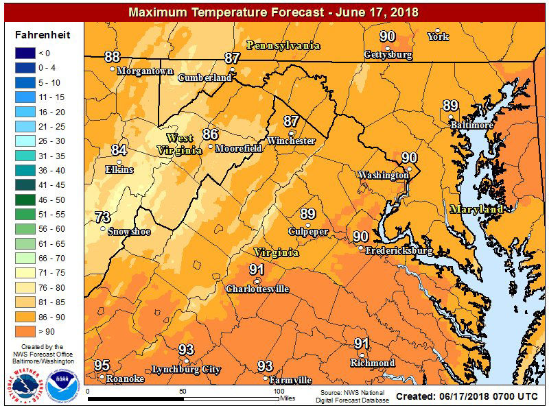
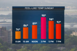
Increasing humidity & an increase in temperatures will make for a very hot afternoon on this #FathersDay. Temperatures will top out in the mid 90s with the heat index close to 100 degrees! Make sure to stay hydrated today with plenty of time out of the sun pic.twitter.com/E9ifCR7hxP
— Lauryn Ricketts (@laurynricketts) June 17, 2018
WASHINGTON — It’s going to be hot on Sunday. And it might be even worse on Monday and Tuesday.
Increasing humidity & an increase in temperatures will make for a very hot afternoon on this #FathersDay. Temperatures will top out in the mid 90s with the heat index close to 100 degrees! Make sure to stay hydrated today with plenty of time out of the sun pic.twitter.com/E9ifCR7hxP
— Lauryn Ricketts (@laurynricketts) June 17, 2018
Even though the summer season doesn’t start until June 20, the D.C. area will be coping with a heat wave starting on Sunday.
Storm Team4 meteorologists were tracking a possible heat wave — a stretch of three consecutive days with temperatures above 90 degrees — but Sunday’s high was one degree shy of 90 degrees. So, it’s not officially a heat wave. But that does’t mean it didn’t feel like 100 degrees with the humidity.
Going to be a little warm if you are grilling tonight …perhaps for #fathersday? Hot and sticky with the heat index during the afternoon around 100 degrees! Watch for a few isolated storms & passing showers. pic.twitter.com/5x61UwrQ63
— Lauryn Ricketts (@laurynricketts) June 17, 2018
The National Weather Service said temperatures overnight would dip down into the high 60s and low 70s, before jumping back up to the 90s on Monday.
The rise of the mercury accompanies the threat of an isolated thunderstorm Sunday, Storm Team4 meteorologist Somara Theodore said. The National Weather Service also said showers and thunderstorms shouldn’t be ruled out for Sunday’s forecast, especially in central Virginia.
Cloud cover will vary from sunny to overcast depending on your location early this afternoon. Mostly dry underneath the clouds, with only a few isolated showers thru early afternoon. A shower or thunderstorm can’t be ruled out late today into this evening. pic.twitter.com/5MBXTVT0tw
— NWS DC/Baltimore (@NWS_BaltWash) June 17, 2018
The National Weather Service has issued a Code Orange air quality alert for Sunday. This means that air pollution concentrations within the region may become unhealthy for sensitive groups, such as children, people with asthma and other heat and lung diseases, and the elderly.
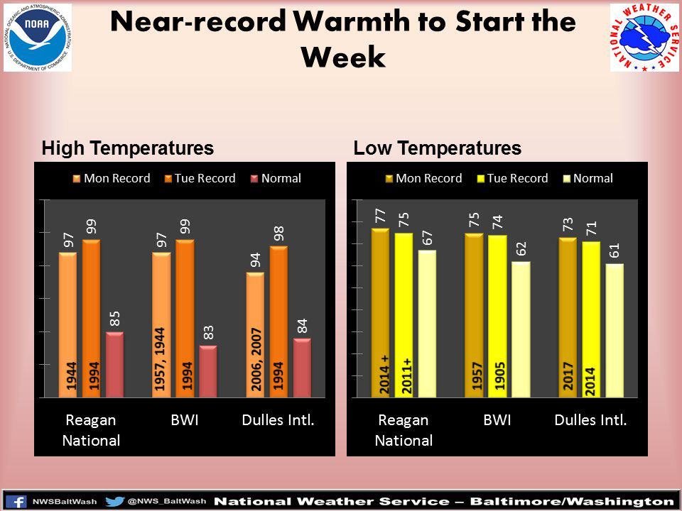
Records could be broken on Monday and Tuesday, with temperatures in the 90s. And, the humidity will make it feel even warmer, the National Weather Service said. It will feel as if it’s in the triple digits.
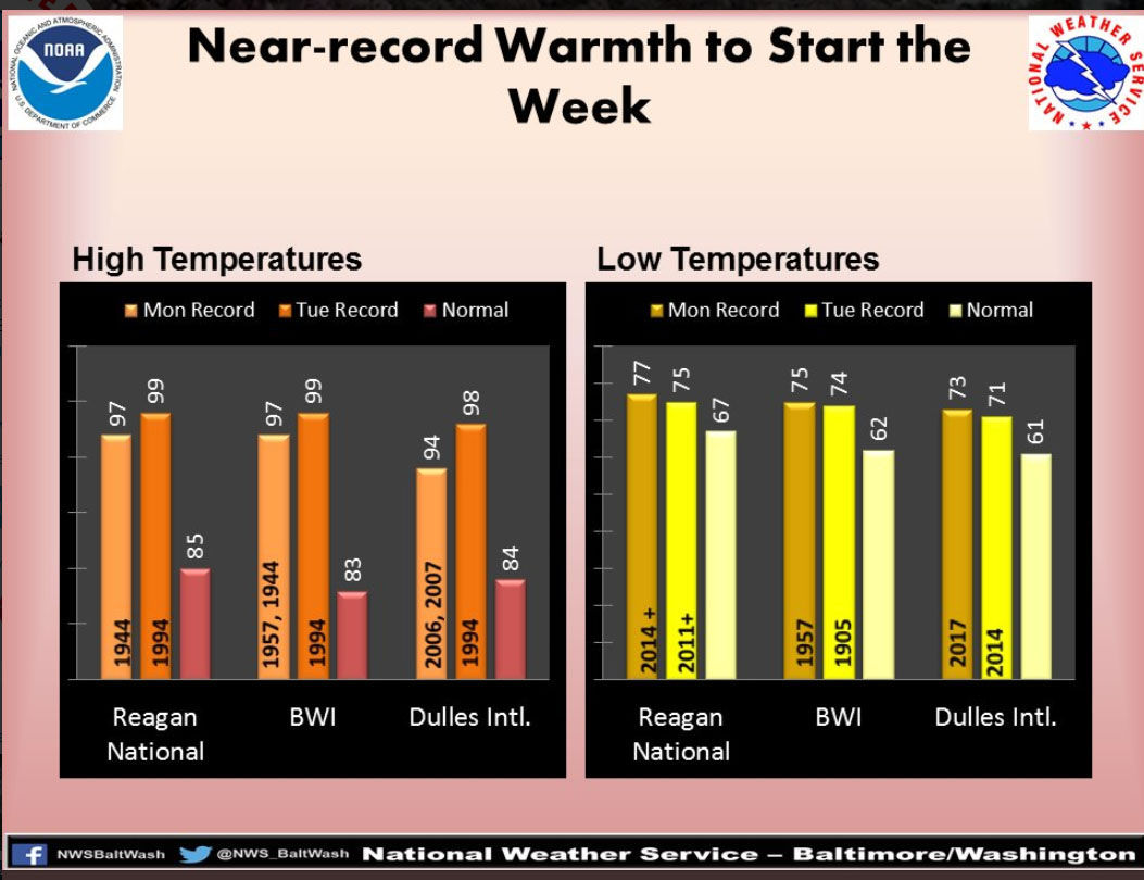
The record high for Reagan National Airport and BWI Marshall Airport for Monday is 97 degrees set in 1944 (and also in 1957 for BWI Marshall); and for Dulles International Airport, it was 94 degrees set in 2006 and 2007.
Tuesday record highs are 99 degrees for Reagan National and BWI Marshall set in 1994; and 98 degrees for Dulles in 1994.
Forecast
- Sunday: Partly sunny, hot and humid. Chance of isolated thunderstorm. Highs in the low to mid 90s. Heat index near 100.
- Monday: Mostly sunny, very hot and very humid. Highs in the upper 90s. Heat index between 100 to 105.
- Tuesday: Partly sunny, very hot and humid. Highs in the mid to upper 90s. Heat index between 100 to 105.
Before the heat set in, the D.C. area enjoyed pleasant weather. Storm Team4 meteorologist Matt Ritter said that the system that brought on those pleasant temperatures may actually be to blame for the heat wave.
“The beautiful weather for the past several days was courtesy of a strong Canadian high pressure system pumping in very dry air,” Ritter said. “But as the center of the high-pressure system moves offshore over the weekend, it will morph into a ‘Bermuda High’ and will pump in higher temperatures and transport moisture from the Gulf of Mexico, making it very humid.”


