WASHINGTON — Spring weather has its ups and downs and Friday promises to bring a wet, and perhaps white, start to the season for some. A return to below average temperatures and a chance of rain mixed with wet snow in the D.C. area is expected.
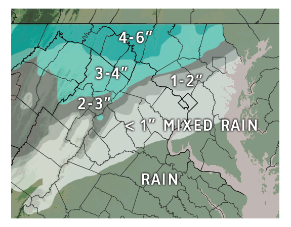
A Winter Weather Advisory goes into effect Friday morning for Montgomery, Howard and Frederick counties in Maryland and northern Fauquier and Loudoun counties in Virginia. One to three inches of wet snow is possible in these areas. A Winter Storm Warning has been issued for the counties in western Maryland where upwards of 5 inches of snow could fall.
A cold, light rain is expected to develop early Friday morning as a weak weather disturbance lifts through the Southeast. Since the rain will fall into a dry airmass, the evaporation of rain drops will lower temperatures near and above the ground. This action will allow the precipitation to begin falling as snow before dawn in some spots. The best chances of accumulating snow early will be north and west of the D.C., the Potomac Highlands, Catoctins and Appalachians.
Wet snow will begin to fall around the metro area during the Friday morning commute. While the odds of an inch or more of snow are highest in the northwestern reaches of the WTOP listening area, there is a chance that some snow could begin coating grassy areas and roof tops in the immediate metro area through the morning hours. The best chance of accumulating snow will be between 4 a.m. and 8 a.m.
By noon on Thursday most of the region’s pavement temperatures had warmed into the 60s and 70s. Well-traveled roads will simply be wet on Friday morning. Some slush is possible on side streets, especially if heavier snow develops. Snowfall and rainfall could alternate through midday before a complete changeover to all rain.

The vernal equinox occurs Friday at 6:45 p.m. and it is around this time that Washington’s late rendezvous with winter will exit stage right. Some light rain showers may linger into the evening.
On the first day of astronomical spring, the sun’s rays are aimed straight down at the equator. Steve Zubrick at the National Weather Service in Sterling says this adds to the challenge of forecasting snow this time of the year.
“You’re fighting the high sun angle, and the longer days, and you really need the snow to fall at night if you want it to have any chance of accumulation on the roads in the metropolitan area. Even if it’s snowing and it’s cloudy there’s still energy from the sun that’s reaching the ground,” Zubrick says.
It is not terribly unusual for the D.C. area to see snow (a trace or more) during the first few weeks of spring. According to records from the National Weather Service, in the last 30 years, it’s snowed 14 times in the city after the vernal equinox.
“The last two years, 2013 and 2014, we have seen measurable snow and it’s been more than an inch at Reagan National Airport.” Zubrick says this is an exception and not the norm. Last winter featured four March storms, two of which produced snow in D.C. after the equinox.
Spring snow also occurred in 1985, 1988, 1990, 1997, 2000, 2003, 2006, 2007 and 2011.
A rare snowfall early on April 7, 2007 produced around an inch of accumulation around the region. The latest measurable snowfall on record in Washington occurred on April 28, 1898.


