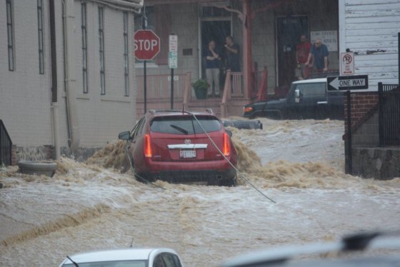
ELLICOTT CITY, Md. — Historic Ellicott City, reeling from its second so-called “1,000-year flood” in two years, will likely never be able to eliminate its high risk of water inundation given its topography and historic designation.
As Howard County officials seek to provide emergency services to twice-devastated residents and business owners on Main Street — the epicenter of the July 2016 and May 2018’s flash flooding — county planners and the U.S. Army Corps of Engineers acknowledge the impossibility of eliminating the risk of future flood damage.
But officials believe a series of smaller, more achievable and less expensive projects can help reduce damage from future flood events.
First, the challenge.
Ellicott City was founded in 1772 and became one of the largest mill towns in the eastern United States, partially because of the same attributes that puts it at high risk for flooding, according to a February 2018 study by the U.S. Army Corps of Engineers conducted at the request of the Howard County government.
“The downtown historic district, often referred to as ‘Historic Ellicott City’ is located in the valley of the upper Western Branch of the Patapsco River, Tiber Branch, Hudson Branch, Autumn Hill Branch, and New Cut Branch all converge to enter the Patapsco River in the vicinity of Ellicott City. The location of Ellicott City at the convergence of these waterways, the topography, and stormwater runoff contribute to significant flood events within Ellicott City and particularly the historic district,” the study said.
While the 2016 flood brought a whirlwind of attention to the normally quiet, lovely, artsy destination, Ellicott City has acknowledged its vulnerability to flooding and for decades has sought to minimize the likelihood of damage while preserving its historic charm.
In 2017, Howard County established the Ellicott City watershed master plan, which remains the bible for the county’s efforts to help the Main Street area endure future floods.
“Ellicott City’s unique topography, hydrology, road network, and mill town heritage will require a tailored, well-planned road map for long-term rebuilding,” the plan acknowledged.
Just two weeks before Sunday’s flooding, Maryland Gov. Larry Hogan and County Executive Allan Kittleman celebrated a $1 million grant from the Federal Emergency Management Agency to improve a culvert near Main Street and improve downtown’s storm drainage network.
Those improvements had been on the county’s watershed project “to do” list.
Nearly three dozen projects, ranging from the already-completed stream cleaning, to the already-funded storm retention ponds, to the soon-to-be installed 48 additional stream gauges for a future early warning system are listed on the county’s watershed master plan website.
After Sunday’s flooding, Kittleman said the projects that had been completed early withstood the torrents of murky brown water.
One already-completed project is a stream channel wall for the Tiber Creek in the 8600 block of Main Street, just west of the hardest-hit area. In that location, the creek runs directly beneath a home.
After the 2016 flood, the county determined it needed to hold back erosion along Main Street, which includes private property, as well as land owned by Howard County. The owner of the home, in an email to WTOP, said she contributed a considerable amount for the county to build the concrete wall.
The channel wall weathered Sunday’s flooding although some of the home’s siding was stripped away by the power of the swollen creek.
Across U.S. Route 40, in the Valley Mede development, a stream restoration project is underway to help provide a better route for the waterway to snake through the neighborhood.
In its 2018 report, the Army Corps of Engineers provided examples of flood-proofing measures for properties in the historic district. The flood-proofing measures included installing flood doors, moving utilities and valuables to higher ground, and building small flood barriers.
The plans were designed to be transferable and customizable for other owners to create their own plans.
The cost of the hardening projects would be borne by the home or business owner and would have to be integrated into the strict architectural requirements of a historic district.
“These measures are meant to reduce flood damages from smaller storms, not reduce the flooding itself,” said Sarah Lazo, a spokeswoman with the Army Corps of Engineers Baltimore Division.
According to Lazo, the Corps has not been asked to do a study on structural possibilities including levees and flood walls that could divert water.
The county’s master plan shows two stormwater retention facilities have been funded and three are being designed.