
The workweek has ended but the winter weather has not. The Washington region is getting a healthy dose of precipitation heading into Saturday morning with some areas under a winter weather advisory. And then we’re in for another round of potential snow on Sunday just for good measure.
- Listen to WTOP online and on the radio at 103.5 FM or 107.7 FM.
- Current traffic conditions
- Weather forecast
- Closings and Delays
- Sign up for WTOP alerts
South and east of the District will see rainfall overnight, with temperatures hovering a few degrees above freezing. Western Maryland and parts of Northern Virginia will not fair so lucky, with some areas seeing snow and others getting freezing rain that will likely cause a build up of ice, especially in regions of higher elevation.
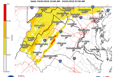
Storm Team4 meteorologist Doug Kammerer called it a “nasty night” with some areas of Western Maryland facing the possibility of 0.2 inches of ice build up.
Precipitation is increasing across the area this evening. A wintry mix can be expected overnight north & west of the Blue Ridge, with a cold rain further south & east into the metros. A Winter Weather Advisory is in effect: https://t.co/ZOlvESgJ2H. #DCwx #MDwx #VAwx #WVwx pic.twitter.com/UBxh9IOw7V
— NWS DC/Baltimore (@NWS_BaltWash) March 2, 2019
“In our colder northern and western suburbs such as Frederick, Luray and Martinsburg where temperatures will be near freezing, a wintry mix of snow, sleet and freezing rain may bring an inch or two of snow and up to two-tenths-of-an-inch of ice,” Storm Team4 Meteorologist Steve Prinzivalli said.
“That’s why the National Weather Service has Winter Weather Advisories posted into tomorrow morning so please watch for slippery spots. The storm will depart early (Saturday), leaving us with a mostly dry and cloudy day and highs in the upper 40s to near 50.”
Saturday offers a brief respite from the wet, with temperatures rising up near 50 but remaining cloudy throughout most of the day. Just as everyone starts drying out, another storm moves in with a chance of rain and snow in the region on Sunday.
The National Weather Service has issued a winter storm watch for Sunday morning through Monday morning for portions of northern Maryland, eastern West Virginia and far northern Virginia.
A Winter Storm Watch has been issued for Sunday morning through Monday morning for portions of Northern Maryland, eastern West Virginia and far northern Virginia. pic.twitter.com/1nNJzKOya1
— NWS DC/Baltimore (@NWS_BaltWash) March 1, 2019
The watch affects Batlimore and Carroll counties in Maryland, and Loudoun and Fauquier counties in Virginia.
The forecast
Saturday: Cloudy and chilly.
Highs: Upper 40s to near 50 degrees
Winds: North to northwest 4 to 8 mphSunday: Winter storm watch north and west of the District
- DC: Cloudy with rain developing by late morning, with some wet snow mixing in overnight. Accumulations of a coating to an inch or two possible.
- North and west: A wintry mix arriving by midmorning and changing to all snow overnight. Accumulations of 2 to 5 inches with up to 8 inches possible along the Mason-Dixon Line.
- South and east: Chilly rain.
- Highs: mid 30s (north and west) to near 40 (south and east)
Monday: Wet snow, rain ending, then clearing, blustery and chilly.
Highs: Mid to upper 30sTuesday: Sunshine, breezy and chilly.
Highs: Upper 30s to near 40 degrees