For the latest on road conditions, school closings and delays, and other developments after Wednesday evening’s snow, click here.
WASHINGTON — A Winter Weather Advisory expired at 2 a.m. for southern Maryland, Anne Arundel, Prince George’s, Calvert, St. Mary’s and Charles counties.
More snow is forecast to spread into the region Friday afternoon becoming heavier Friday night and into Saturday. By Sunday morning, 1 foot to 2 feet of snow is forecast to be on the ground throughout the region.
Along with snowfall rates of 2 to 3 inches per hour, the storm will bring gusty winds and blowing snow, which combined will make travel treacherous and bring the chance for structural damage and power outages.
More than 48-hours before the first flake will fall, the National Weather Service issued a Blizzard Watch just as D.C. Mayor Muriel Bowser announced the city’s preparations for the storm Wednesday morning. Area residents have already begun to stock up on grocery staples and reschedule weekend plans.
“Get ready to hunker down at home this weekend,” said Storm Team 4 meteorologist Amelia Segal.
Even Southern Maryland, which is also forecast to see rain mix with the snow, could see snow totals up to 18 inches, Segal said.
“Once you get over 8 inches in this area, that’s crippling,” she said.
The dangerous weather could shut down area airports and roads. Secondary roads could remain snow-covered for days after the storm ends, she cautioned.
The watch takes effect Friday afternoon and runs through late Saturday night for the D.C. region. But some snow could continue into early Sunday, she said.
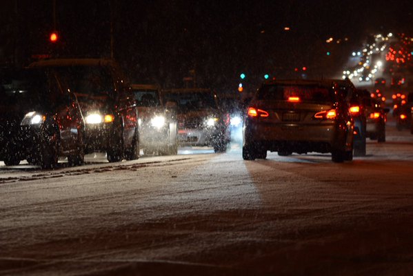
But first, snow started to fall during the Wednesday evening commute, creating slippery roads and extensive traffic gridlock.
The weather service issued a Winter Weather Advisory from 6 p.m. to 2 a.m. Thursday.
Meanwhile the frigid temperatures continue. Excessive ice in the Potomac River closed White’s Ferry between Loudoun and Montgomery counties.
Thursday is expected to be calm with highs in the mid to upper 30s.
Blizzard watch in green and winter storm watch in blue from midday Friday – early Sunday for 1 to 2 feet of snow. pic.twitter.com/7vwPq6BSUK
— Amelia Segal (@ameliasegal) January 20, 2016
The storm forecast
Storm Team 4 meteorologist Lauryn Ricketts says the snow could move into the region by Friday midday or into the afternoon. A few isolated areas could start off as rain or a wintry mix (the National Weather Service says that’s possible east of Interstate 95).
The heavy snow should come Friday night through Saturday afternoon, and winds will increase in the late afternoon and evening, getting even stronger overnight into Saturday. Wind gusts could reach 40 to 50 mph, bringing the chance for power outages.
By Saturday morning, as much as 8 inches of snow could be on the ground. But the storm is expected to drop more than a foot of snow total throughout the region by the time the system moves out, Ricketts says. However Southern Maryland and the Eastern Shore will likely see less snow because they could see more of a mix of precipitation, Ricketts says.
Roads could be closed or impassable from Richmond to Philadelphia. And the weight of the snow could also damage roofs or other structures, she says. The National Weather Service says that the combination of heavy snow and wind “will be a threat to life and property.”
Travel will be “severely limited if not impossible” from Friday night through Saturday, they add, and visibility will be near zero with “whiteout conditions” possible. The weather service adds that residents should “stock up on necessities,” “make plans for elderly family and those most at risk” and prepare for power outages.
The definition of a blizzard is a storm with 35 mph winds, visibility that is less than a quarter of a mile and a storm duration of at least three hours.
Latest snowfall map, this is looking like a top 5 biggest snowstorm Friday afternoon into early Sunday. Prepare now! pic.twitter.com/RywkH1BgH8 — Amelia Segal (@ameliasegal) January 20, 2016
Snowmageddon 2?
The impending storm has brought back memories of Snowmageddon, the back-to-back storms in 2010 dumped more than 2 feet on some parts of the area. Forecasters are studying the computer models, wondering whether this week’s storm could reach the same level.
“It’s a small possibility at this time,” says Luis Rosa, a meteorologist with the National Weather Service. “We can’t completely rule it out.”
But this storm is following a similar pattern to one of the Snowmageddon storms, which hit on a Friday and Saturday, Segal says.
After that storm, some area school systems were closed for four days — because road conditions remained poor especially in rural areas.
Preparations begin
Pepco warns customers that power outages could last for several days.
Spokesman Bob Hainey says the utility is planning for the worst.
Both Pepco and Baltimore Gas and Electric are calling in extra crews and setting up storm operation centers. Justin Mulcahey with BGE reminds customers to report any loss of power and prepare an emergency plan together.
Mulcahey says that power customers keep extra batteries, flashlights, battery-operated clock radios and nonperishable food on hand. And he suggests they download their power company’s mobile app to report outages.
The Northern Virginia Electric Cooperative says they’re preparing for the snow and possible outages caused by snow-laden trees and branches resting on power lines. They’re preparing their vehicles for snowy road conditions and going to “all hands on deck” scheduling.
System operations president Larry Shaffer says that NOVEC customers should call 703-335-0500 or 1-888-335-0500 to provide the company with up to two current phone numbers to help with reporting outages and restorations.
Snow plow crews are getting ready, too. Get information for snow plows in Virginia, Maryland and D.C..
D.C. Mayor Muriel Bowser details the District’s snow preparations: