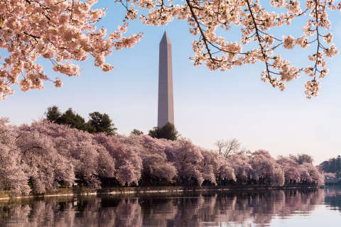
WASHINGTON — D.C. is approaching peak cherry blossom season, which means thousands of visitors will flock to the Tidal Basin to take in the sights.
The National Cherry Blossom Festival officially kicks off March 20 and lasts through April 16. But with the warmer temperatures , expect more visitors on the National Mall and throughout downtown D.C. this spring.
From buses, bikes and boats to a bed for the night, here are your best options for getting around D.C. as you take in the sights. Metro may still be your best for navigating toward the Tidal Basin, but be warned, there are several service cuts affecting two key Metro lines throughout the month of March.
Cherry blossom parade road closures
D.C. police released a list of road closures for the National Cherry Blossom Festival Parade that will block off a main thoroughfare of downtown D.C. starting early April 8.
Here is a map of the closures:
The full list of closures is below:
Early closure 3 a.m. to 1 p.m.
- 7th Street between Constitution Ave. NW and Independence Ave SW
Closures from 10 a.m. to 1 p.m.
- 9th Street between Pennsylvania Ave. NW and Constitution Ave. NW
- 10th Street between Pennsylvania Ave. NW and Constitution Ave. NW
- 12th Street between Pennsylvania Ave. NW and Independence Ave. SW / SE SW freeway
- Access to 12th Street Tunnel from I-395 ramp SW
- 14th Street between Pennsylvania Ave. NW to Independence Ave. SW
- 14th Street Bridge ( inbound) all traffic sent to I-395 freeway SW
- 15th Street between E Street to Constitution Ave. NW
- 17th Street between New York Ave. NW to Independence Ave. SW
- 19th Street between E Street to Constitution Ave. NW
- Virginia Ave between 20th Street to Constitution Ave. NW
Metro
Even if you’ve taken Metro to see the cherry blossoms, be prepared for some changes this year.
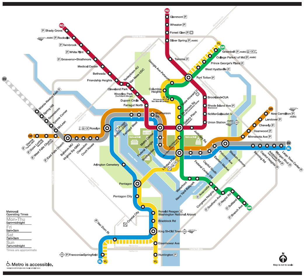
First, here’s a map of the Metro system. Fare costs vary depending on time and length of travel. The best stops to view the blossoms along the Tidal Basin are the Smithsonian, Foggy Bottom and L’Enfant Plaza stations. You can find fare details and plan your trip on Metro’s website.

If you’re planning to head into D.C. on the Metro from Alexandria, parts of Arlington and other points south of D.C., you may encounter delays. Round-the-clock track work will significantly disrupt Metro train service south of Rosslyln and L’Enfant Plaza, including at the Pentagon, Reagan National Airport, King Street, Franconia-Springfield and Huntington stations. These cuts last through April 1.
During the track work, Blue and Yellow Line trains are only scheduled every 24 minutes at all times of day.
However, additional Yellow Line trains will run between Reagan National Airport and Mt. Vernon Square to provide service every 12 minutes.
Regular weekend service is planned for the Red, Green, Orange and Silver lines.
Expect the same plan for the weekends of April 1-2 and 8-9.
To avoid delays, even before boarding trains, Metro suggests adding enough money to your fare card for travel to avoid lines at vending machines downtown.
Metro also suggests that riders avoid the Smithsonian station, which can be rather crowded during the bloom, and instead consider the L’Enfant Plaza, Archives or Federal Triangle stations.
Read more about the disruptions and how to navigate around them on WTOP’s track work guide.
Capital BikeShare
Capital BikeShare is the D.C. area’s best way to get around on two wheels. The program offers more than 3,700 bicycles at more than 440 stations throughout the D.C. region.
Check a bike out at one station and return it to any station near your final destination. The Capital BikeShare station map shows you where you can find available bikes.
The cost is $2 per trip and $8 per day. You can purchase a three-day pass for $17. You can find more information about pricing and signing up on the Capital BikeShare website.
The National Mall Circulator
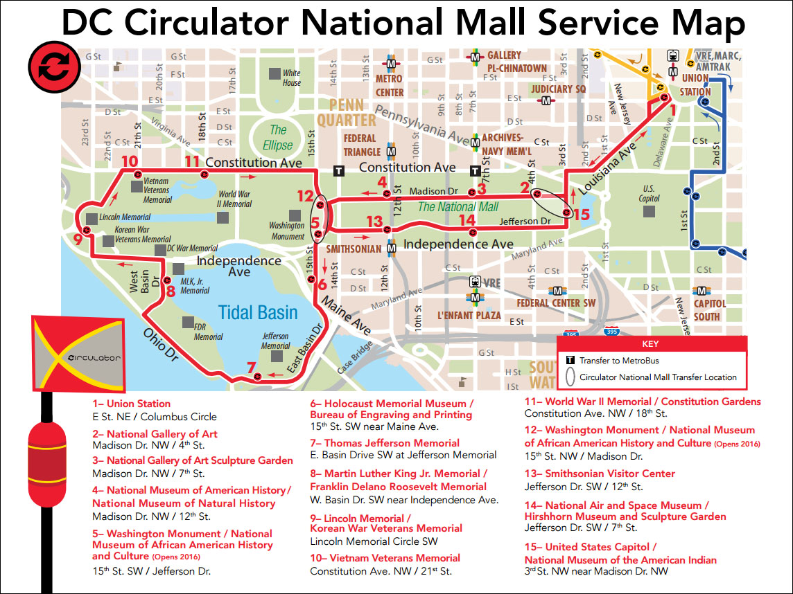
The National Mall Circulator bus route hits nearly all the major landmarks along the National Mall, including the Lincoln Memorial to the west and U.S. Capitol building and Union Station to the east.
Here’s a map of the route along the National Mall.

It costs a dollar to ride, but with your SmarTrip card you can get on and off the bus as much as you want during any two-hour time period. Buses are scheduled to arrive every 10 minutes.
Taxi and Car Services
Need a taxi? There’ll probably be plenty in downtown D.C. that you can hail directly off the street.
The D.C. Department of For-Hire Vehicles (formerly the D.C. Taxicab Commission) has a new smartphone app that allows you to hail a taxi using your smartphone.
Ride-hailing companies Uber and Lyft also operate in D.C. and are options for downtown travelers.
Boat rides and other options
If you really want to beat the crowds on the streets near the Tidal Basin, you could get a view of the cherry blossoms from the Potomac River instead.
The D.C. Water Taxi offers cruises Potomac cruises that provide views of Jefferson and Lincoln Memorials, the Kennedy Center and other sights. Riders can board in Georgetown or near the National Mall by the FDR Memorial.
Service begins March 16. Tickets are $20 for adults and $10 for children and must be purchased in advance. You can find more information on the D.C. Water Taxi website.
The Potomac Riverboat Co. is offering sightseeing cruises along the cherry blossom route from March 25 through April 30.
Pricing information and more details are available on the Potomac Riverboat Company’s website.
Need a place to crash?
There are a number of hotels in D.C., and a number of sites through which to book. The National Cherry Blossom Festival features hotels with special rates and packages through its website.


