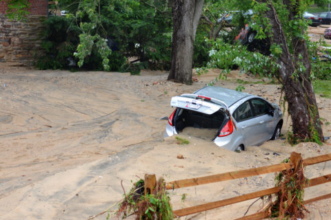
The motto “turn around, don’t drown” is used to dissuade drivers from dangerously forging through floodwaters. Drivers on a highway in Maryland have been doing a lot of turning around in recent years.
Maryland Route 450, or Defense Highway, courses through a low-lying, marshy area between Crofton and Annapolis. A portion of the highway near the confluence of three South River tributaries is often submerged after periods of rain.
But state officials say the flooding is getting worse and indicate that climate change may be playing a role.
Over the last year, records from the WTOP Traffic Center database show that the road was closed on at least 60 nonconsecutive days because of flooding. The highway was impassable for multiple days in a row after heavy rainfall events in late July, early August and again in late September.
The closures usually flicker on a portable electronic sign situated on the corner of Route 424 and Route 450. The mobile sign mounted on an orange trailer was meant to be a temporary means of guiding drivers toward U.S. Route 50 and away from the high water. It has become a permanent fixture of the intersection in recent years.
When it comes to flooding, “this road is the second most frequently closed road in Maryland,” state Sen. Ed Reilly told WTOP. He noted the most flood-prone road was a small, country route in rural Worcester County.
Reilly, a Republican who represents District 33 in Anne Arundel County, considers the repeated flooding of Defense Highway to be a public safety issue. Police and paramedics on their way to emergency calls must routinely divert around the closures, he said, adding minutes to their response times.
Route 50 and Interstate 97 are limited access highways and do not provide rescue personnel access to the communities along and near Route 450. Other county services also are hampered by the flooding.
“When the road is closed, the school system does not send its school buses to pick up or return children to school, so there’s probably 30 families which are adversely affected every time the road is closed,” Reilly said.
While the exact number of recent flood-related closures is murky, Reilly contends that Route 450 was closed 89 times in less than a year. Another count from the Maryland Department of Transportation lists a total of 21 closures since last summer, some lasting upward of three days.
The highway can remain hazardous even after the flooding recedes. As the water level falls, a layer of sandy sediment is often left behind. Trees will occasionally uproot in the mud and topple onto the highway. During winter cold snaps, a hazardous icy sheen forms on the driving surface near low culverts that carry the North River and Bell Branch under the road.
“What has happened in the past few years is the rain volume has increased dramatically and has softened the roadbed underneath,” Reilly said. The state senator and some transportation officials believe that the road is sinking as the soft, sandy soil is undermined each time the nearby tributaries exceed bank-full.
According to the Maryland Department of Natural Resources, urbanization has increased the magnitude and frequency of discharges associated with even small and moderate rainfall events, particularly in the Coastal Plain area of the state. The Maryland State Highway Administration, responsible for the maintenance of Route 450, has reached a similar consensus.
“The increased closures in the past year have resulted from historic rain events and continuing development in the area that increases impervious surfaces, which then increases the volume and velocity of stream flows,” said Maryland Department of Transportation spokesperson Charlie Gischlar.
Gischlar said the highway agency is, “evaluating several engineering solutions, both short-term and long-term, to address the frequency of high water.” A contract for the culverts and ditches to be cleaned and dredged on a regular basis is in the works.
Reilly met with Maryland Transportation Secretary Pete Rahn earlier this month. In the meeting, Rahn indicated that $1 million would be allocated toward efforts intended to cut the recurrence of flooding by a little more than half. But funding for more substantial fixes to permanently keep the highway above water is still lacking.
MDOT plans to start replacing four old culverts that carry water under the road and toward the South River this summer. The excavation will likely require the closure of Route 450 for several weekends.
Last year was the rainiest year on record for the region and 2019 is beginning to follow suit. Year-to-date rainfall tallies at BWI Marshall Airport and Reagan National Airport are slightly above average but far outpacing last year’s numbers. Month-to-date totals are more than double May averages so far.
The National Weather Service in Sterling, Virginia, said that a new preliminary 365-day running precipitation record of just over 71 inches was set by Sunday night. Route 450 was underwater and closed most of the day.
“The high level of rain is not going to stop. It’s part of our climate change. This is an ongoing, persistent problem that needs to be addressed sooner or later,” Reilly said.