How much did it rain the past 24 hours? This graphic gives an estimate of 24-hour rainfall, and you can see that if you were southeast of Baltimore & Washington, you received a lot more rainfall than if you were northwest of the major cities. pic.twitter.com/spAsP4yxkg
— NWS DC/Baltimore (@NWS_BaltWash) February 12, 2018
The Flood Watch has been cancelled across the region. Flood Warnings (bright green areas) remain in effect for portions of our area where excessive runoff from earlier rains is causing flooding. Latest: https://t.co/5RyZgpeTAT #DCwx #MDwx #VAwx #WVwx pic.twitter.com/8eQsskz5bI
— NWS DC/Baltimore (@NWS_BaltWash) February 11, 2018
Changes to flood watch areas and radar update. pic.twitter.com/Zz8vIAW4ia
— NWS DC/Baltimore (@NWS_BaltWash) February 11, 2018
Flood Watch canceled early for a lot of the listening area. Still in effect in areas of dark green until Midnight (correction for local time *grrrrrr*). Flood Warnings in bright green until 7:45pm or sooner. pic.twitter.com/3wEMJRmafk
— Matt C Ritter WTOP (@MetMattRitter) February 11, 2018
FLOOD WARNING until 700 PM Sunday for central Anne Arundel, northern Calvert, and east-central Prince Georges counties in Maryland. Between 2 and 3 inches of rain has already fallen and additional heavy rain is expected this afternoon across the warned area. pic.twitter.com/BQz2zifmOy
— NWS DC/Baltimore (@NWS_BaltWash) February 11, 2018A flood warning was extended to 7 p.m. for central Anne Arundel, northern Calvert and Prince George’s counties in Maryland.
Radar estimates (1st img) from NWS Sterling site show that many areas in VA and southern MD have picked up over 3" of rainfall this week. The red and pink areas are getting more heavy showers/storms this afternoon. #wtop pic.twitter.com/9S7wrldt7y
— Matt C Ritter WTOP (@MetMattRitter) February 11, 2018
The "overall" rain coverage has evolved today, too. Now it's more like showers, but they're persistently moving over the same areas. FLASH flood threat may be increasing south and east of DC. Stay with #wtop and #nbc4dc pic.twitter.com/k8Mrb1qnwY
— Matt C Ritter WTOP (@MetMattRitter) February 11, 2018
Turkey Hill Rd Closed
— Charles Co Sheriff (@CCSOMD) February 11, 2018
between Dower Hill Farm and Spalding Dr due to high water.
View map https://t.co/iNwcyhSVz1
Weekend rains are impacting #SWVA highways. Drivers, please be alert for flooded highways & debris. #turnarounddontdrown Call @511southwestva or @511statewideva for road conditions in #Virginia. pic.twitter.com/ErGNyySCbf
— VA State Police (@VSPPIO) February 11, 2018
FLOOD WARNING until 230 PM Sunday for south-central Anne Arundel, northwestern Calvert, and southeastern Prince Georges counties in Maryland. Between 2 and 3 inches of rain has already fallen and steep rises are being observed at many locations in the warned area. pic.twitter.com/COdvCatjBE
— NWS DC/Baltimore (@NWS_BaltWash) February 11, 2018
A Flood Watch has been issued across much of our region starting this evening and continuing through Sunday evening. Repeated rounds of heavy rain may lead to flooding. Please keep aware of the weather tonight through Sunday night; flood warnings may be necessary. pic.twitter.com/qychEKni4W
— NWS DC/Baltimore (@NWS_BaltWash) February 10, 2018
Light rain overspreading portions of west-central VA and the eastern WV panhandle this morning. Flood watch for area shown in image starts this evening and continues into Sunday evening. pic.twitter.com/vx8kdd80AE
— NWS DC/Baltimore (@NWS_BaltWash) February 10, 2018Some area may see anywhere up to 0.75 inches to 2 inches of total rainfall. (Courtesy Marcus Hoyt)
Rain has overspread the region and periods of rain will affect the region through the remainder of the weekend. Some locations will see in excess of 2". A Flood Watch remains in effect for portions of the area. pic.twitter.com/CPpZO6wD8F
— NWS DC/Baltimore (@NWS_BaltWash) February 10, 2018The rain is expected to taper off Sunday after lunch, but more shows will move back into the D.C. area late Sunday night and early Monday morning. (Courtesy Marcus Hoyt)
Once again the NW suburbs are not getting into the warm sector. Wide range in top temperatures this afternoon, much cooler with patchy fog there. Much warmer near and SE of the District. #dcwx #mdwx #vawx #wtop pic.twitter.com/mKruMOfQh7
— Matt C Ritter WTOP (@MetMattRitter) February 11, 2018There is a wide range of temperatures in the D.C. area on Sunday afternoon. (Courtesy Marcus Hoyt)
WASHINGTON — Heavy rains falling over the weekend have led to flood watches and warnings throughout the D.C. region. The rain lasted through Sunday, and some roads were closed due to rising waters and flooding.
Weather
In Maryland, a flood warning issued for north Charles County and southern Prince George’s County was extended until 12:15 a.m. Monday. The flood warnings in east Prince George’s County and Anne Arundel County were extended until 9:30 p.m. Sunday.
In Virginia, a flood warning for Stafford and Spotsylvania counties along with the City of Fredericksburg expired at 7:45 p.m. Sunday.
A flood watch that affected most of the D.C. area on Sunday has been canceled.
Temperatures on Sunday varied depending on location within the D.C. area, although temperatures everywhere were above normal. North and west of D.C., temperatures hovered in the 40s and 50s. South and east of D.C., temperatures topped out in the 50s and 60s.
The showers will wind down by early Monday morning. It will be breezy and temperatures will drop into the mid to upper 40s.
A very light wintry mix is possible on Tuesday.
Roads
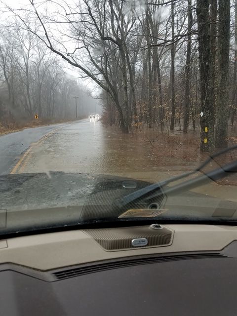
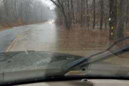
The rain is flooding roads throughout the area and causing delays. In Charles County, several roads are closed or partially closed due to high water.
In Anne Arundel County, Md. Route 214 is closed at Fern Hill Court due to flooding and traffic is being diverted.
Here’s a look at traffic conditions throughout the region.
The drought
When it rains, it pours. But the bout of moisture might not be a bad thing for the D.C. area.
Following the recent period of sleet and rain, the much needed precipitation will continue to fall, potentially putting an end to the severe drought that has troubled the D.C. area.
Radar estimates (1st img) from NWS Sterling site show that many areas in VA and southern MD have picked up over 3″ of rainfall this week. The red and pink areas are getting more heavy showers/storms this afternoon. #wtop pic.twitter.com/9S7wrldt7y
— Matt C Ritter WTOP (@MetMattRitter) February 11, 2018
Some areas have seen up to 3 inches of total rainfall.
WTOP’s Dave Dildine said that the area has seen a precipitation deficit of about 5 to 8 inches, and the weekend rain may help steer the area out of its severe drought status.
Check WTOP’s weather page for updates on conditions and WTOP’s traffic center to see how the winter weather is affecting the roads.