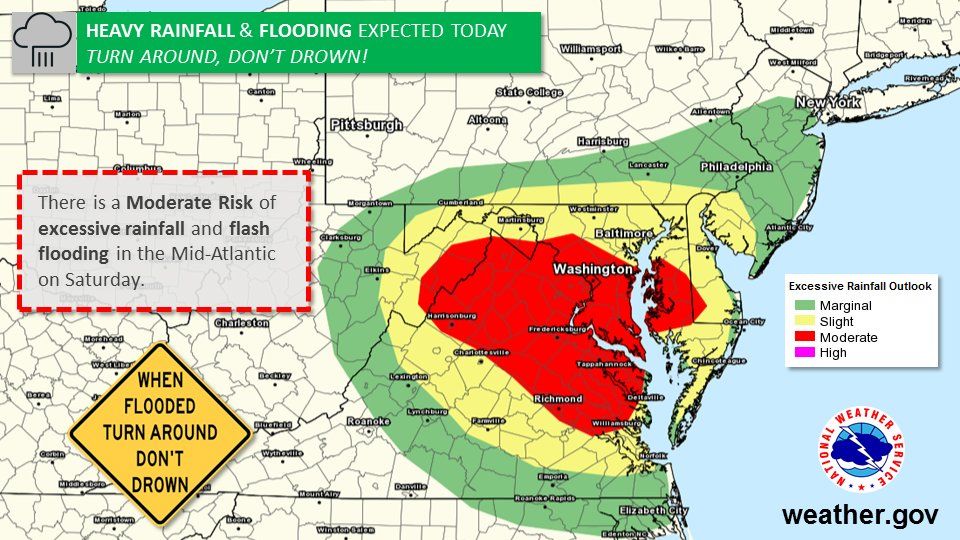
Moderate risk for rainfall today exceeding flash flooding guidance (which is around 1") ->flooding likely around our region heading into the aft/eve with slow movers. Please down NBC app for latest on the radar (track it yourself) & abide by road closures pic.twitter.com/sM6q92shoi
— Lauryn Ricketts (@laurynricketts) June 2, 2018
No rain this morning, but the entire area is in a Flash Flood Watch until 6am Sunday and we are in WeatherAlert. Showers/few t'storms increase this afternoon, soaking rains possible overnight and early Sunday, which will be cool, damp, and raw for June. @wtop #nbc4dc pic.twitter.com/BilTvx4XZ3
— Met. Matt Ritter (@MetMattRitter) June 2, 2018
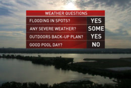
A good chance of flooding today with a few inches of rain possible heading into the overnight. Rain chances increase through the afternoon with a few storms around. Make sure you have a backup plan for any outdoor events! Pool=earlier the better pic.twitter.com/p124ljZR7X
— Lauryn Ricketts (@laurynricketts) June 2, 2018
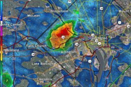
It is a MUGGY one once you step outside this morning. Temperatures steady - in the 60s/70s now across the region with mist/fog, clouds/sunshine (depending on your location). Rain chances increasing today with flooding likely. pic.twitter.com/rhK6vTd1vE
— Lauryn Ricketts (@laurynricketts) June 2, 2018
Looking gorgeous this morning in #DC. The sun come up at 5:44am and is peeking through the clouds. More clouds and more rain (again) today. A BIG flooding threat. We are WeatherAlert today! Timing out the rain all morning on @nbcwashington & @WTOP pic.twitter.com/HDvEOgcoQF
— Lauryn Ricketts (@laurynricketts) June 2, 2018
WASHINGTON — Parts of the D.C. area had a brief reprieve from rain on Friday, but Saturday evening is back to rain by the buckets-full.
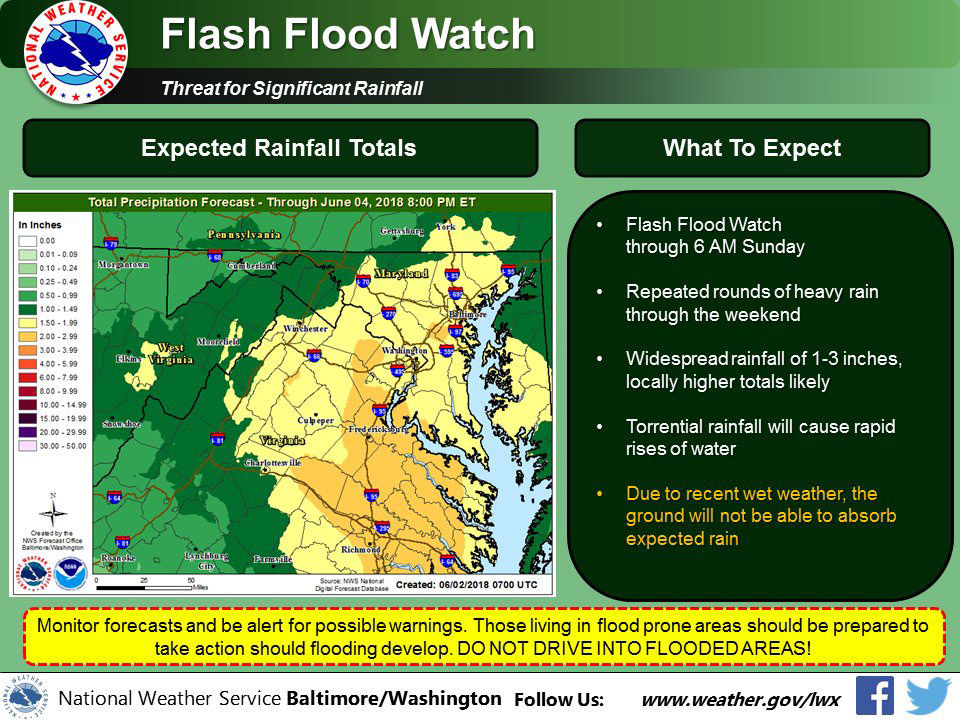
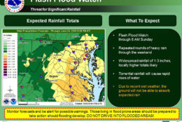
The National Weather Service has issued a flash flood watch through 6 a.m. Sunday for most of the D.C. area.
Parts of the D.C. area could see as much as 1 to 3 inches of additional rain. Because the D.C. area has already gotten so much rain, the ground will not be able to absorb this rainfall.
Quick Links:
A flood warning is in effect in the following counties:
Virginia
- Fauquier County
- Frederick County
- The City of Winchester
The flood warnings are in effect for Frederick County and Winchester until 1:45 a.m. Sunday.
The National Weather Service says the Rappahannock River at Remington is under a flood warning as well, which could affect Fauquier County and Culpeper County.
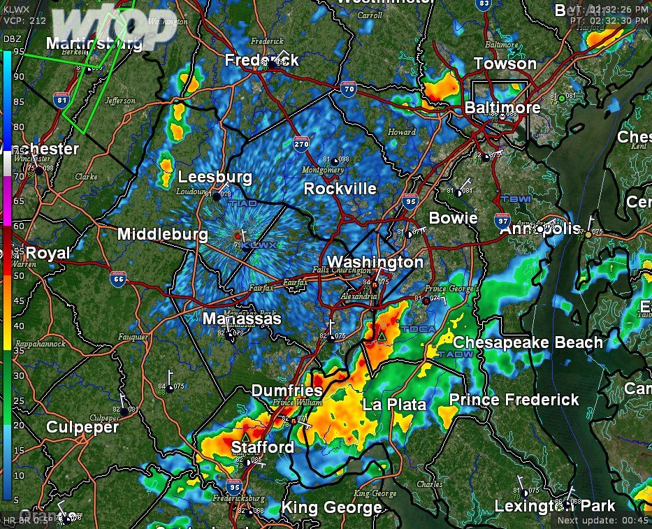
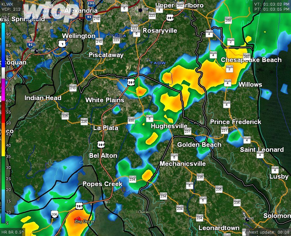
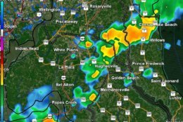
In areas of Prince George’s County and Charles County in Maryland, a non-flash flood warning is in effect until 7 p.m. Some roadways were already starting to flood around 3 p.m.
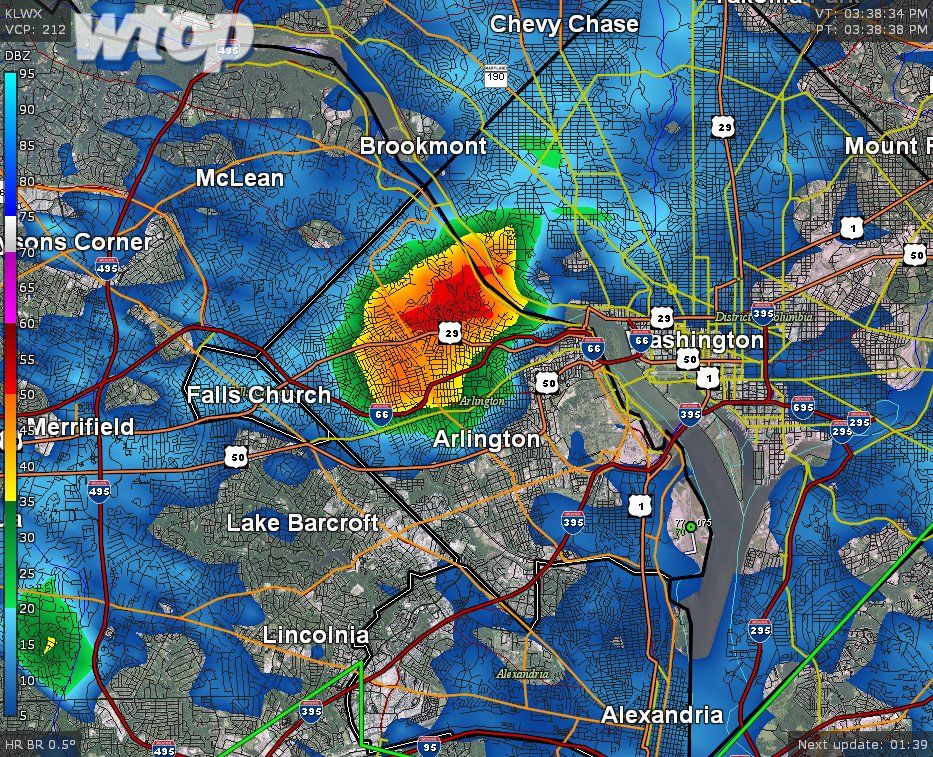
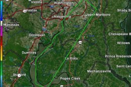
Within the warned area, rainfall estimates for the past several hours between 1″ if not 3″ in some spots. Luckily it hasn’t all come down at once, which is why this particular warning is not “flash” flood. pic.twitter.com/FbxTPPcezl
— Met. Matt Ritter (@MetMattRitter) June 2, 2018
A flood watch affects the following areas:
D.C.
Maryland
- Calvert County
- St. Mary’s County
- Baltimore County
- Baltimore
- Anne Arundel County
- Prince George’s County
- Howard County
- Charles County
- Montgomery County
- Carroll County
Virginia
- City of Alexandria
- Arlington County
- Fairfax County
- Stafford County
- Prince William County
- Loudoun County
- Fauquier County
The weather service said as of 2 a.m. Saturday, the Potomac was at 6.8 feet, flood stage is at 16 feet and that minor flooding was possible. The river could reach flood stage by early Monday morning.
Meteorologist Matt Ritter said Storm Team 4 expects this area of Maryland to experience the biggest flash flooding threat overnight.
“That could be particularly dangerous for overnight drivers,” Ritter tweeted.
Even where it isn’t raining yet, Ritter warned against being too optimistic about the storms passing.
“Basically from now through overnight, any dry weather is on borrowed time,” Ritter tweeted.
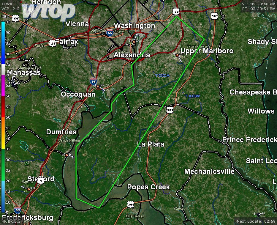
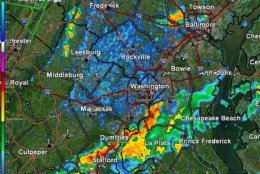
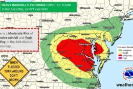
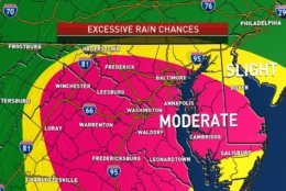
The Mid-Atlantic is currently under a “moderate” level risk for flash flooding and excessive rainfall, according to the National Weather Service. The affected area covers all of D.C., most of Southern Maryland and most of Northern Virginia.
In Southern Maryland, rainfall has already started in some areas. Ritter said Stafford, Virginia, up through Western and Southern Maryland are experiencing storms. He warned drivers to be careful of pooled water on roadways.
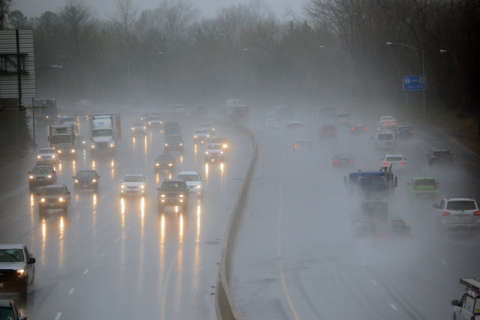
Saturday started out dry, but rain moved in by the early afternoon, turning heavy at times by late afternoon and evening.
“Some of these cells will be rather slow movers increasing flooding chances on an already saturated ground,” said Storm Team 4 meteorologist Lauryn Ricketts.
Ricketts warns that it won’t take much rainfall for flooding to occur, so everyone should be “weather ready” in the region.
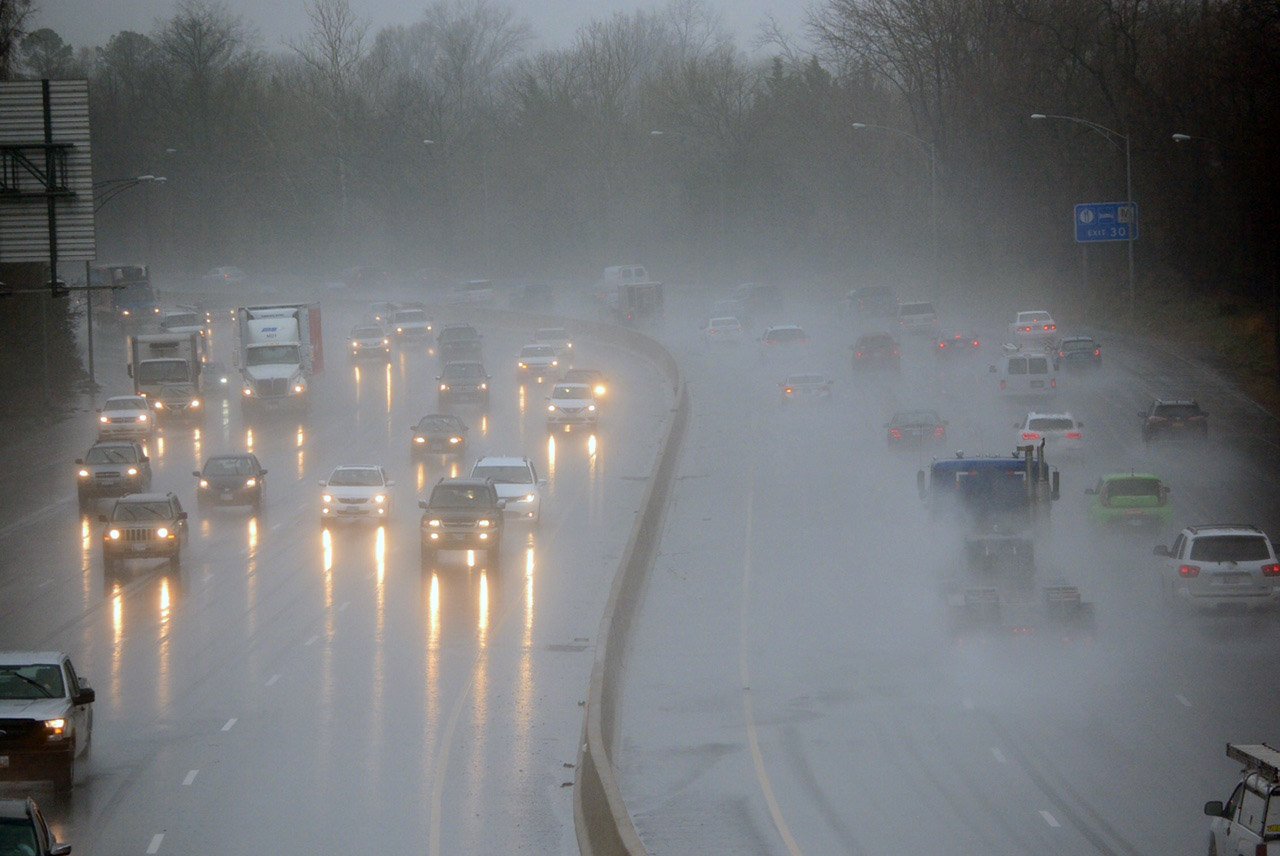
Drivers should use extreme caution.
“Avoid high, fast moving water at all costs,” said Storm Team 4 meteorologist Chuck Bell. “Turn around. Don’t drown!”
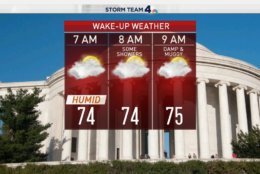
Showers and periods of rain are expected throughout the day on Sunday. Temperatures are expected to drop into the mid to upper 60s, well below the average of 81 degrees.
A cold front arrives Monday, Bell said. But rain is likely again as highs hover in the low to mid 70s.
Current Conditions
Traffic
In addition to the weather, there are several street closures in D.C. for Stanley Cup Final. You can see where the closures are if you’re heading in to the city.
For the most updated traffic report, visit WTOP’s traffic center. You can see a map of the latest traffic conditions below.
Weekend Forecast
Saturday
Saturday started out cloudy and cooler, with highs in the high 70s to low 80s. The morning had dry weather, but a low pressure area is expected to form over the Chesapeake Bay that could cause persistent rains later in the day. Expected rainfall is between 1 and 3 inches.
Sunday
An unseasonably cool day in the mid to high 60s could be expected. Periods of showers and rain are expected throughout the day.
Monday
A partly cloudy day is expected on Monday. Pleasant temperatures will hover in the low to mid 70s, but there is a chance for rain.